High Seas [Quenched]
Moderator: Cartographers
Forum rules
Please read the Community Guidelines before posting.
Please read the Community Guidelines before posting.


Re: High Seas, update pg.12 [I]
its pretty cool i cant say yes or no so ill say both


Re: High Seas, update pg.12 [I]
what about having a territory on each land mass with a high neutral resetting neutral like 15 or something so if you wanted to cross the land, you could do so but at great penalty. might be interesting, but might over complicate things.
just a thought.
just a thought.
-
Sam Pootang
- Posts: 12
- Joined: Thu Mar 27, 2008 4:32 am
Re: High Seas, update pg.12 [I]
I really like it and i think it will make a great map, and i really like mibi's idea of having a big neutral on each of the bits of land so you can cross the land but it comes at a cost.
All in all great map.
All in all great map.
-
Sir. Ricco

- Posts: 4555
- Joined: Tue Oct 02, 2007 2:33 pm
- Gender: Male
- Location: Making kingdoms burn and bloodshed start.
- Contact:
Re: High Seas, update pg.12 [I]
That would be insane with the Infected Neutral.mibi wrote:what about having a territory on each land mass with a high neutral resetting neutral like 15 or something so if you wanted to cross the land, you could do so but at great penalty. might be interesting, but might over complicate things.
just a thought.


Re:
edbeard wrote:well he has 42 territories at the moment, so I'm not sure why adding one more territory would help. Also, the Australia shape at the moment is done not only for gameplay reasons, but also for fitting into the aesthetics and history that the map is trying to acheive.
in short
I think its fine the way it is now with 42 terits, but are you sure that Australia was connected during the time period that oaktown is going for? This was during the 1200-1600 i think. THe drawings on the outside look like somethng from the Muslims.

Re: High Seas, update pg.12 [I]
I'm not saying it actually was connected. He's basing this map on maps that they had back then. Mapmakers back then thought it was connected. At least, this is what I'm gathering from what Oaktown has done. I'll let him give more detail on it.
I'm not too fond of the land connections idea (at least not on this map). He's going for a classic style map so I don't think that fits in with his plans for this map.
I do like the idea in general and it could be a nice bit of gameplay for another map entirely.
I'm not too fond of the land connections idea (at least not on this map). He's going for a classic style map so I don't think that fits in with his plans for this map.
I do like the idea in general and it could be a nice bit of gameplay for another map entirely.
Re: High Seas, update pg.12 [I]
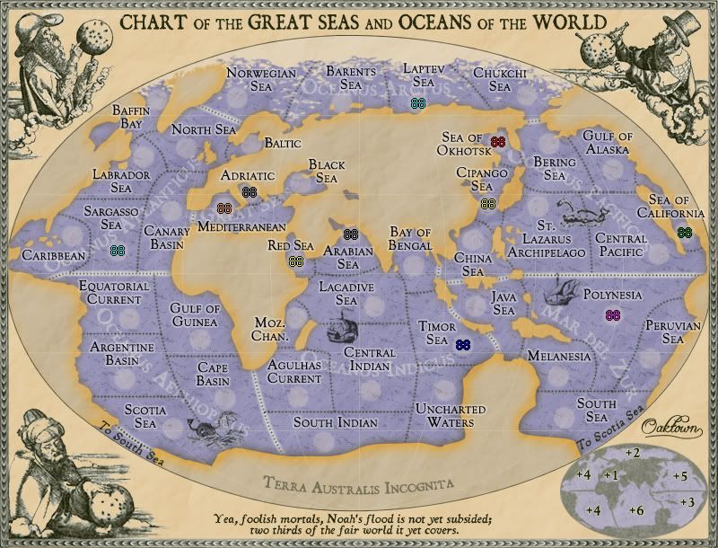
There's absolutely no changes here... just dropped some army counts on the big map. The small map I made by shrinking the large file and then increasing the outer glow on the army circles - not sure how well the idea worked.
Anywho, I'm not sure where I'm at on this - I think I'm cool on play, so now it's down to graphics. Somebody tear into it and give me some direction.
Anywho, I'm not sure where I'm at on this - I think I'm cool on play, so now it's down to graphics. Somebody tear into it and give me some direction.
- Click image to enlarge.

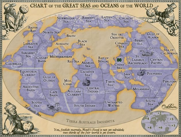
Re: High Seas, update pg.10 [I, GP]
Hmmm - Graphics wise I dunno...
As much as I like this idea... it's perhaps a little bland... is that because there is a lot of map area that is blank (i.e. the land)...
But I have no idea how you can change that - without drawing the attention away from the sea(s)!?
Unless - you go slightly differently - and put some different colours into the oceans and seas... but then again - will that ruin your 1600's (or whatever) aesthetic!?
C.

Highest score : 2297
-
gimil

- Posts: 8599
- Joined: Sat Mar 03, 2007 12:42 pm
- Gender: Male
- Location: United Kingdom (Scotland)
Re: High Seas, update pg.10 [I, GP]
Oaktown crrect me if im wrong but didnt you say you plan to to a little landscaping to the dead space? This may be enought to counters yeti_c's problem.
What do you know about map making, bitch?
Top Score:2403natty_dread wrote:I was wrong
-
AndyDufresne

- Posts: 24919
- Joined: Fri Mar 03, 2006 8:22 pm
- Location: A Banana Palm in Zihuatanejo
- Contact:
Re: High Seas, update pg.10 [I, GP]
You could add some landscaping images...such as perhaps some mountains near the Alps, maybed the Himalayas also...Grasslands and Forests in Africa perhaps similar things in the New World area also. Just general generic things people knew from the time period.
--Andy
--Andy
Re: High Seas, update pg.10 [I, GP]
But not too many - as then it will take away from the actual areas of the map that are in play!AndyDufresne wrote:You could add some landscaping images...such as perhaps some mountains near the Alps, maybed the Himalayas also...Grasslands and Forests in Africa perhaps similar things in the New World area also. Just general generic things people knew from the time period.
--Andy
C.
Highest score : 2297
-
gimil
- Posts: 8599
- Joined: Sat Mar 03, 2007 12:42 pm
- Gender: Male
- Location: United Kingdom (Scotland)
Re: High Seas, update pg.10 [I, GP]
Im going to disagree with images. Ive always prefered maps with images kept to a minimim.
What do you know about map making, bitch?
Top Score:2403natty_dread wrote:I was wrong
-
whitestazn88
- Posts: 3128
- Joined: Mon Feb 05, 2007 2:59 pm
- Gender: Male
- Location: behind you
- Contact:
Re: High Seas, update pg.10 [I, GP]
i think some texture is required... because it still is a map. you know what i mean? like they probably still keep the names of places on a map even if its not the part of the map they're using (ex. putting the name of russia and mongolia in a map of china, because you can still see parts of it.
so i like andy's idea of putting in some stuff
so i like andy's idea of putting in some stuff
Re: High Seas, update pg.10 [I, GP]
- Click image to enlarge.


Re: High Seas, update pg.10 [I, GP]
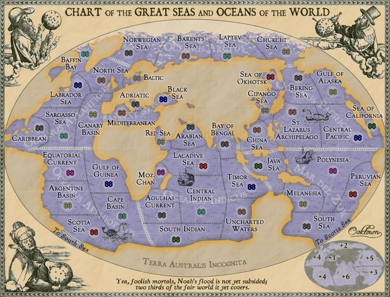
BTW Oaktown, I love this map. I'm going to look at it closer when I get a few moments, but thought I would chime in.

-
AndyDufresne
- Posts: 24919
- Joined: Fri Mar 03, 2006 8:22 pm
- Location: A Banana Palm in Zihuatanejo
- Contact:
Re: High Seas, update pg.10 [I, GP]
Beautiful!
--Andy
--Andy
Re: High Seas, update pg.10 [I, GP]
- Click image to enlarge.
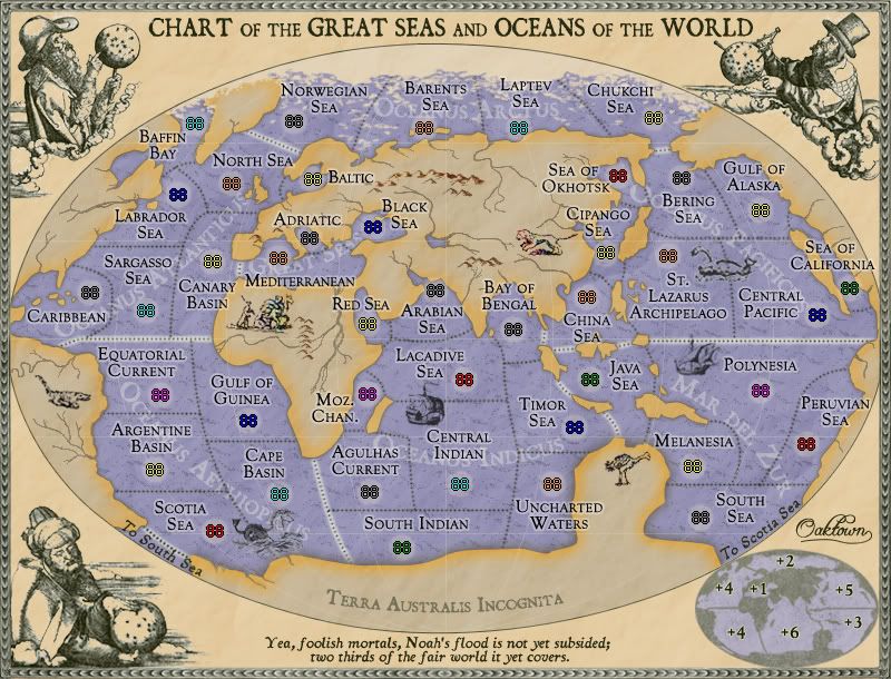
Next on the to do list is the XML.
-
Incandenza

- Posts: 4949
- Joined: Thu Oct 19, 2006 5:34 pm
- Gender: Male
- Location: Playing Eschaton with a bucket of old tennis balls
Re: High Seas, update pg.10 [I, GP]
Wow. Just... wow. Nicely done, sir. I think any more on the land would unforgivably clutter things up, so you've got a nice balance there.
THOTA: dingdingdingdingdingdingBOOM
Te Occidere Possunt Sed Te Edere Non Possunt Nefas Est
Te Occidere Possunt Sed Te Edere Non Possunt Nefas Est
Re: High Seas, update pg.10 [I, GP]
I was against it until you put the animals there.
it's too bad gimil didn't deputize me for this thread too 'cause you'd have that stamp right now
it's too bad gimil didn't deputize me for this thread too 'cause you'd have that stamp right now