
I toyed with doing a Scandinavia myself, but my total inability to function graphics programs plus my zero knowledge of XML were sort of obstacles.
My concept was to go for a very large map much like World 2.0, with sub-regions and much larger regions. For instance, Sweden would be as you have it except you would get another bonus for holding all of Sweden. Norway would have more territories and split into 2 regions, all of Norway for a bigger bonus. The Baltic States would be divided into several territories to make them each a small region, and holding all Baltic States would be another big bonus. Finland would be further divided the same way.
I would also include every country in the image you have, including Russia, Germany, Poland, and Belarus.
If you are at all interested in doing it like this, I can go into more detail and link you to the maps that I was looking at for reference.
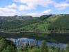
Scandinavia Map
Moderator: Cartographers
Forum rules
Please read the Community Guidelines before posting.
Please read the Community Guidelines before posting.
LOL, World 2.0 is by far one of the most popular maps. I understand if you don't like it, it IS very big, but a LOT of people do and it's the only one of its kind. Most maps are scaled for 4 or 5 people games. If you like doubles, be happy, you've already got almost all the maps. But that's no reason to discourage any other map from ever being different from your preference.eeked wrote:World 2.0 is useless, it's simply to large.
I think the scandinavian map shows good promise for 4-player games, either in doubles or singles.
-
Ruben Cassar
- Posts: 2160
- Joined: Thu Nov 16, 2006 6:04 am
- Gender: Male
- Location: Civitas Invicta, Melita, Evropa


I don't know about that. Then I should change the names of all the parts of Finland too and they're too long in my opinion..Ruben Cassar wrote:Change Finland's name to Suomi.
And the name of the Baltic countries too...
About the Nordic 2.0 version. I'm sure it would be nice, but I'm not a big fan of that map either so I think it's better if someone ells does it...
I want to to do a Swedish map in the future, but this will get finished first.
When you say northern Norway, I guess you mean Norrland - that is northern Sweden. I guess I could change it to 4, no problem. It's kinda big and have 4 borders though..
Last edited by Dogonsi on Wed Mar 07, 2007 5:29 pm, edited 1 time in total.


I can try and see if I can make it look good and if the names fit...Wisse wrote:mayby make the finlands country names finish, the norwegan names norweganish (^sp) etc.
I included the Baltics cause they were included in the other version. I think it feels natural to have them on the map, since all the other countries that you can see all of on the map are included. I know it's not Scandinavia anymore, so maybe it's a bit off topic, but no one could agree on what areas belongs to Scandinavia so I included all the parts you can see on the map...
-
Mr Tumbler

- Posts: 35
- Joined: Mon Jan 29, 2007 7:32 pm


They were the correct size when the map was 699px wide. He shrank the map to 600px wide and the shades with it, so he needs to redo those.Wisse wrote:army shades are to tiny
I agree here, there are several regions which look like you simply couldn't defend them. Well, Sweden basically. Gotaland and Svealand need some love with impassable borders.qwert wrote:you dont have impasabile borders?
The old map (^) is much superior to this one. Maybe Andy shoudl contact the other cartographer and check if hes no more interested in finish it? It would be fair, too.RexRegis wrote:Current version

Edit: Hahaha, I had imagined this guy doing the recent version was from Sweden, and its confirmed
Baltics as one territory each. Norway, Finland and Denmark, all as one continent... then Sweden as 3 continents. What a patriot!

the new one has the potential to be better than the old one. A few suggestions.
Table/design for key
Neutral territoies perhaps dark brown or dark grey to give it a lift
Army circles bigger (quite a bit)
Army shadows lighter
Danmark should be 3
Can vastmanland attack Halsingland?? make it clearer
Make svetland the green that is on baltikum and then make baltikum yellow
Make every colour slightly brighter
Make the lake by narke and ostergotland clearer i thought it was paer of narke at a short glance
Maybe it is better, but would be nice if you could specify what is better.Marvaddin wrote: The old map (^) is much superior to this one. Maybe Andy shoudl contact the other cartographer and check if hes no more interested in finish it? It would be fair, too.
Sure I'm swedish, and my mother is from Denmark so that's not why. If you look at wikipedia or any other place you could see that these are natural borders with real names. That wasn't the case with the other map. Sweden consist of three parts and I didn't want to make any other fake parts just to make it two parts. Sweden is also by far the biggest country and this looks like a natural way to split the map into continents.Marvaddin wrote: Edit: Hahaha, I had imagined this guy doing the recent version was from Sweden, and its confirmed
Baltics as one territory each. Norway, Finland and Denmark, all as one continent... then Sweden as 3 continents. What a patriot!
Sure. But I can't of like it this way too. It looks kinda clean.boberz wrote:the new one has the potential to be better than the old one. A few suggestions.
Table/design for key
Neutral territoies perhaps dark brown or dark grey to give it a lift
Will do. I did this version to test the map and the xml code.boberz wrote: Army circles bigger (quite a bit)
Army shadows lighter
But Danmark has 4 countries whereof 2 has borders, just like Baltikum.boberz wrote: Danmark should be 3
Can vastmanland attack Halsingland?? make it clearer
You can't attack that way, that's how the borders were from the beginning, but I guess I could make it even clearer.
Ok, why? This way was the version that I found worked best, you can see the light yellow text clearly on all bakgrounds this way. I tried with darker text first, but this way seemed better.boberz wrote: Make svetland the green that is on baltikum and then make baltikum yellow
Make every colour slightly brighter
Clearer in what way? Maybe I can move the text Närke so you can see the lake better?boberz wrote: Make the lake by narke and ostergotland clearer i thought it was paer of narke at a short glance

The big brown line between Sweden and Norway is supposed to be impassable. I Think it's obvious that it is, but maybe not?Samus wrote:I agree here, there are several regions which look like you simply couldn't defend them. Well, Sweden basically. Gotaland and Svealand need some love with impassable borders.qwert wrote:you dont have impasabile borders?
I could add some impassable borders if you think it's neccessary? Maybe a river north of Östergötland so it's only Småland that is connected with Östergötland?
Like I said before, I don't want to add borders that don't exist and that includes the impassable ones. I don't like maps where they've added a mountain just to make an impassable border.