Page 7 of 8
Posted: Mon Oct 15, 2007 3:10 pm
by gimil
SAM is your list finallised yet? If so can you post the lastest version? I will get some work in tonight
Posted: Mon Oct 15, 2007 3:54 pm
by sam_levi_11
unfortunatly the list stands as last time but im working on it when i can, coukldnt today as i got had probs at college but...
Posted: Wed Oct 17, 2007 5:41 pm
by iancanton
sam_levi_11 wrote:we need names for:
chiao chin
he pu
yu lin
t'sang wu
i've found names for the above four territories from a bulletin board discussion about china invading vietnam. post #3 gives the answers.
http://www.chinahistoryforum.com/index. ... opic=10661
At the end of the Eastern Han, Northern Vietnam was divided into the Han prefectures of Rinan (south), Jiuzhen (central) and Jiaozhi (north). Together with the prefectures of what is now Guangdong and Guangxi (Nanhai, Hepu, Cangwu and Yulin), it was administered as a single province called Jiaozhou, under a Governor.
modern chinese pinyin convention is for place names to be written as one multisyllabic word, not as two words hyphenated. although it's not essential that we do this, we must be consistent across the whole of the map.
ian.

Posted: Wed Oct 17, 2007 9:38 pm
by unriggable
Not a fan of the idea that green can be defended from three countries but is worth 8.
Posted: Thu Oct 18, 2007 4:05 pm
by sam_levi_11
iancanton wrote:sam_levi_11 wrote:we need names for:
chiao chin
he pu
yu lin
t'sang wu
i've found names for the above four territories from a bulletin board discussion about china invading vietnam. post #3 gives the answers.
http://www.chinahistoryforum.com/index. ... opic=10661
At the end of the Eastern Han, Northern Vietnam was divided into the Han prefectures of Rinan (south), Jiuzhen (central) and Jiaozhi (north). Together with the prefectures of what is now Guangdong and Guangxi (Nanhai, Hepu, Cangwu and Yulin), it was administered as a single province called Jiaozhou, under a Governor.
modern chinese pinyin convention is for place names to be written as one multisyllabic word, not as two words hyphenated. although it's not essential that we do this, we must be consistent across the whole of the map.
ian.
thanks dude uv helped alot
Posted: Fri Oct 19, 2007 3:31 am
by bloknayrb
I think the bonuses are a little high all around, but they balance out I guess, so it's all good.
Posted: Sun Oct 21, 2007 9:05 am
by iancanton
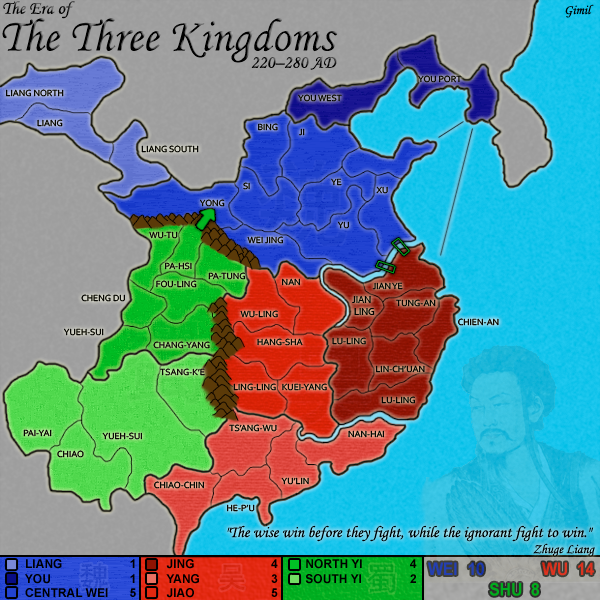
i forgot to mention something. we need to juggle the names of the three wu provinces. the southernmost province, which consists of nanhai, hepu, cangwu and yulin, is on our map as yang. the paragraph below clearly says it is called jiao. the eastern province of wu is supposed to be yang, which means that, by elimination, jing must be wu's northern province.
http://www.chinahistoryforum.com/index. ... opic=10661
At the end of the Eastern Han, Northern Vietnam was divided into the Han prefectures of Rinan (south), Jiuzhen (central) and Jiaozhi (north). Together with the prefectures of what is now Guangdong and Guangxi (Nanhai, Hepu, Cangwu and Yulin), it was administered as a single province called Jiaozhou, under a Governor.
ian.
Posted: Sun Oct 21, 2007 9:11 am
by gimil
iancanton wrote:i forgot to mention something. we need to juggle the names of the three wu provinces. the southernmost province, which consists of nanhai, hepu, cangwu and yulin, is on our map as yang. the paragraph below clearly says it is called jiao. the eastern province of wu is supposed to be yang, which means that, by elimination, jing must be wu's northern province.
http://www.chinahistoryforum.com/index. ... opic=10661
At the end of the Eastern Han, Northern Vietnam was divided into the Han prefectures of Rinan (south), Jiuzhen (central) and Jiaozhi (north). Together with the prefectures of what is now Guangdong and Guangxi (Nanhai, Hepu, Cangwu and Yulin), it was administered as a single province called Jiaozhou, under a Governor.
ian.
thanks Iain.
SAm have you finalised that lsit? if so PM it to me adn ill work on it this week.
Posted: Sun Oct 21, 2007 4:01 pm
by sam_levi_11
as promised
liang
liang continent is properly called xi liang.
you
you continent is bei ping
central wei
the one above xu is called ben hai
ye is xia pi
chang an is where si is
xu chang is where yu is
he fei is where u have xu
wei jing is jei ting
central wei should be worth 7 as it was historically very hard t take over and cao cao just mde it look easy.
north yi
the name for north yi is riverlands.
chang yang is yong an
tian shui is where pha si is i think.
south yi
pai yai and chiao is northeast of where the nanman kingdom was, when shu took it over they joined so make that a separate continant under shu maybe worth 2. then split yue sui up, this new continent shopuld be worth 4. yong an can be the north part and keep the name for the south part.
yang
yang is jiao
jiao is jing
chiao-chin is jiaozhi
nan-hai is nanhai
he-p'u is hepu
yu-lin is cangwu (location is present-day wuzhou)
ts'ang-wu is yulin (location is present-day guilin)
move pearl river to left side of nanhai
make cangwu smaller so it does not border the sea
use pearl river to separate nanhai from hepu
narrow the upstream part of pearl river so nanhai borders cangwu
add mountains between nanhai and luling
jing
so there, me and ian did about 55:45...looks like you have two helpers gimil lol
Posted: Mon Oct 22, 2007 4:27 pm
by iancanton
sam
hope this is clearer! i've removed hyphens and spaces from all of the new place names and, after studying historical territory descriptions from the webpage below, i propose some geographical amendments.
http://www.anu.edu.au/asianstudies/decr ... china.html
yang is jiao
territory names:
chiao-chin is jiaozhi
nan-hai is nanhai
he-p'u is hepu
yu-lin is cangwu (location is present-day wuzhou)
ts'ang-wu is yulin (location is present-day guilin)
geography:
move pearl river to left side of nanhai
make cangwu smaller so it does not border the sea
use pearl river to separate nanhai from hepu
narrow the upstream part of pearl river so nanhai borders cangwu
add mountains between nanhai and luling
jiao is jing
territory names:
hang-sha is changsha
ling-ling is lingling
kuei-yang is guiyang
wu-ling is wuling
geography:
add mountains between changsha and luling
jing is yang
territory names:
i haven't done enough research to establish what the pinyin names are supposed to be, but maybe u have the answers already!
geography:
merge the two luling territories into one.
ian.
Posted: Mon Oct 22, 2007 7:24 pm
by gimil
Guys can we have a finalised list. I was about ot start work until i realised there was 2 lists.
Posted: Mon Oct 22, 2007 7:29 pm
by Jack0827
I bought my ps2 so I could play dw5, it is still a game that I go back to when I get tired of Halo

I think that it looks good but I also think that you should put in graphics to help give it a more anciant china feel
p.s. I love WU

Posted: Mon Oct 22, 2007 7:55 pm
by sam_levi_11
editied, we are missing jiao and thats it
Posted: Wed Oct 24, 2007 8:18 pm
by iancanton
this nice map shows pinyin names for all of the wu territories in ad 229! do u think this is good enough to be definitive for our purposes?
http://www.anu.edu.au/asianstudies/decr ... _map16.gif
ian.
Posted: Wed Oct 24, 2007 8:31 pm
by sam_levi_11
ian im taking break from cc so get all of wu done and move on to the gameplay eh...gl. its why i havent been able to do much lately...
Posted: Mon Oct 29, 2007 4:29 pm
by KingPrime
update?
have you forgotten this map, or are you too busy with the FW map.
Posted: Mon Oct 29, 2007 6:08 pm
by jako
probably busy and still working on the update.
Posted: Sun Nov 25, 2007 2:30 am
by Coleman
gimil, what is going on with this? (reposted for a nudge up)
Posted: Sun Nov 25, 2007 7:05 am
by gimil
Coleman wrote:gimil, what is going on with this? (reposted for a nudge up)
like i told you the 1st two times ive lost my flash drive with hte file on it, i currently have no movvitvation to start dont this and feudal again. So for the time being it will be feudal, but i will come back to this.
Posted: Mon Feb 18, 2008 5:58 pm
by KingPrime
you coming back to this anytime soon?
Posted: Sun Mar 16, 2008 9:06 pm
by KLOBBER
This map sucks ass. I can't even see the names of the territories because they're practically invisible against the background, what to speak of actually reading them.
This would be a very poor map to play.
Posted: Sun Mar 16, 2008 9:12 pm
by edbeard
KLOBBER wrote:This map sucks ass. I can't even see the names of the territories because they're practically invisible against the background, what to speak of actually reading them.
This would be a very poor map to play.
actually they're quite easy to read and it does look fun. It is on vacation though.
Trolling doesn't accomplish anything. Here's the latest version I saw in the thread by the way.
Posted: Sun Mar 16, 2008 9:12 pm
by wcaclimbing
KLOBBER wrote:This map is awesome. I love how you did the names of the territories because they really stand out against the background, they are really easy to read
This would be a very fun map to play.
That is a very interesting response.
I like the map, but not the key. the solid blocks of color just aren't working for me.
But since this map is on vacation, I will leave it alone for now.
Posted: Sun Mar 16, 2008 11:25 pm
by Unit_2
Well.. Gimil lost the psd file and he plans to restart this after his other maps are done.
I can't wait
Posted: Mon Mar 17, 2008 3:20 am
by KLOBBER
Unit_2 wrote:Well.. Gimil lost the psd file....
Thank God for small favors. This map sucks dog ass.