
At that point I see 3 possibilities:
- fading rivers so the double border line is more proeminent
putting a lot more bridges and making river all impassable
removing rivers as impassable and making them mere decoration
Moderator: Cartographers
Can we see some examples.pamoa wrote:Again I'm not going to make river disappear just when I don't need it as border.
At that point I see 3 possibilities:
- fading rivers so the double border line is more proeminent
putting a lot more bridges and making river all impassable
removing rivers as impassable and making them mere decoration

Pamoa I think you have talent but sometimes you're way too stubborn mate. I guess that's why it's always the same two or three people commenting in this thread.pamoa wrote:Again I'm not going to make river disappear just when I don't need it as border.
At that point I see 3 possibilities:
- fading rivers so the double border line is more proeminent
putting a lot more bridges and making river all impassable
removing rivers as impassable and making them mere decoration


Ruben Cassar wrote:...stubborn mate...
Do you really want to discuss my map in your thread? I haven't done any updates on it for ages so I don't know what you're referring to. If you have some constructive comments to make you can post in the Cyprus thread. I don't want to hijack your thread even if you're inviting me.pamoa wrote:Ruben Cassar wrote:...stubborn mate...
btw how did you managed to make nicosia territoriy across an impassable border if you are able to work on it again

Sounds about right to me!pamoa wrote:You are right they are not french, neither part of the United Kingdom but British Crown dependencies since 1066 when William became King of England. It is the last bit of the Duchy of Normandy since the 10th century and Queen Elizabeth II is often referred to by her traditional and conventional title of Duke of Normandy.
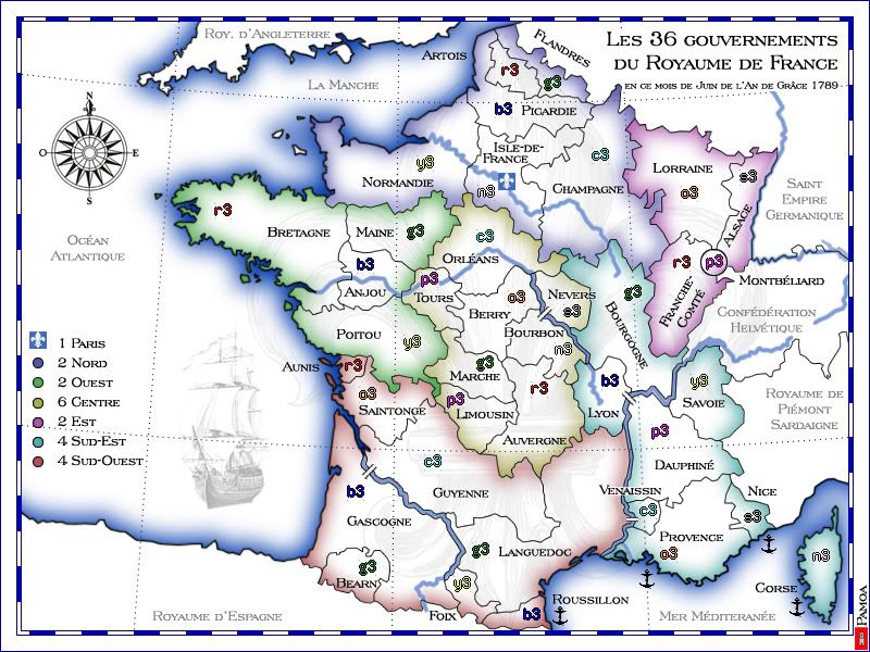
So they will go white on the map.
I'll try to find a place to put some names but the one you suggested are not very adequateqwert wrote:names for countrylight blue- Rhones-Alpes
- yellow- centre
green- Pays de la Loire
Blue- Pays du Nord
red- Alsace-Loraine
pink- Bassin de la Garonne


I have to say I'm going to disagree with this - there has been a lot of discussion on this - and what we have now is the best of it... and I think the effect is really good.The Neon Peon wrote:I really do not like having a blue river convert to a gray river, then back again to blue. could you simply make the entire river blue, but make it really thin, but still use bridges? Possibly have it thicken slightly where you have a bridge.

I'll try something elseTaCktiX wrote:The subtle continent names are a good attempt, but due to the myriad of terrain features are really difficult to read and end up muddling the map (though that's not intended). Instead of big wide semi-transparent names, what about smaller but more distinctive continent names?
The Neon Peon wrote:I really do not like having a blue river convert to a gray river, then back again to blue. could you simply make the entire river blue, but make it really thin, but still use bridges? Possibly have it thicken slightly where you have a bridge.
yeti_c wrote:I have to say I'm going to disagree with this - there has been a lot of discussion on this - and what we have now is the best of it... and I think the effect is really good.
This river stuff could last for ages and I know I will read comments about it even when it will be online, if it never goes.MrBenn wrote:I like the rivers as they currently are - bridges in the middle of a territory get too confusing - the solution here is an excellent one.
The map is 600x800 which is less than the 800x840 authorised. I don't see any benefits in having a narrower, crowded map.MrBenn wrote:Is it just me, or does the map seem to be too wide? I'm sure you could cut off 50-100 pixels from the left-hand-side of the map without impacting on the playable area at all?? You'd probably need to move the compass/minimap/ship, but I don't think that's a big issue??

Benn I am going to have to respectfully disagree with you on this one. I think the map is nicly presented without any space being left unutilised. He probably could reduce the size but I don't think their is a real need for it.MrBenn wrote:Is it just me, or does the map seem to be too wide? I'm sure you could cut off 50-100 pixels from the left-hand-side of the map without impacting on the playable area at all?? You'd probably need to move the compass/minimap/ship, but I don't think that's a big issue??
Top Score:2403natty_dread wrote:I was wrong

Thanks for commenting. This map started as white based Ireland-like map. At the start see was even less strong. So what you see is, I think, a good compromise.RjBeals wrote:I think when I look at this map, I don't like the glow in the water. Maybe there's just too much white in general. If I remember correctly, the glow was a big discussion point a while ago. So much so, that you took a break from development. I don't want that to happen - but I personally would prefer less glow, less white, and more solid color.


