Page 13 of 39
Posted: Wed Dec 12, 2007 10:48 am
by hulmey
the army circles in cumberland and dumfries are not round!!
Posted: Wed Dec 12, 2007 10:55 am
by gimil
hulmey wrote:the army circles in cumberland and dumfries are not round!!
check again adn zoom in, i assure you there round adn 22px in diameter.
Posted: Wed Dec 12, 2007 12:22 pm
by hulmey
Im not blind!!! Dont need to zoom in!! Im looking at the map on Page 20 and there are 2, if not more that arent round. They are fairly near the border lines, so this could be the problem!
Ps..you cant call a district "oxon"!!
Posted: Wed Dec 12, 2007 12:51 pm
by yeti_c
hulmey wrote:Im not blind!!! Dont need to zoom in!! Im looking at the map on Page 20 and there are 2, if not more that arent round. They are fairly near the border lines, so this could be the problem!
Ps..you cant call a district "oxon"!!
You can - and people do...
Go here...
http://www.oxfordshirebadminton.co.uk/m ... 20Contacts
Some of these addresses have OXON in...
C.
Posted: Wed Dec 12, 2007 12:53 pm
by spinwizard
You have plenty of room, just use the full names!

Posted: Wed Dec 12, 2007 1:15 pm
by gimil
hulmey wrote:the army circles in cumberland and dumfries are not round!!
yes they are, its an illussion on your part becasue of the glow used in the boarders.
Posted: Wed Dec 12, 2007 2:16 pm
by LFAW
Gimil, its Donegal.
Not how you spelt it

Posted: Thu Dec 13, 2007 10:04 am
by EmperorOfDaNorth
So, seeing that we're finally discussing Hadrian's Wall, do you suppose the Romans over-stretched in getting that thing built all the way out in the swampy periphery of their empire, when they could have built it around Rome, twice, and have something useful against the Germanic tribes that later conquered Rome?
Isn't it a bit like owning S. America on the Classic map, with Africa suddenly falling into your hands and then spending loads and loads of armies on fortifying Egypt and East Africa so much that someone just walks into your front door in Venezuela?
Come on, you all have CC experience: Did the Romans goof up?
As for the point that it shouldn't be there given the contemporary nature of all other names and boundaries: Well, perhaps, but then most other maps have really weird and arbitrary limitations of where you can or cannot go just the same, so let's not worry about it.
Posted: Thu Dec 13, 2007 11:02 am
by Ogrecrusher
Lincolnshire still needs a capital L!
Posted: Fri Dec 14, 2007 6:09 pm
by gimil
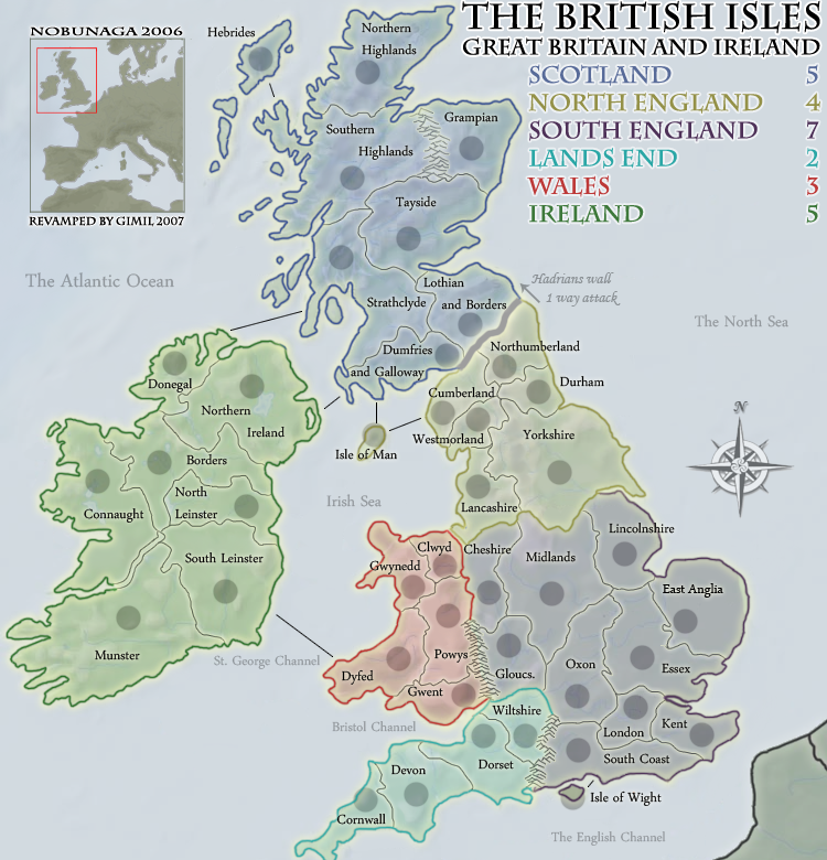
small changes, theres no way to get a wall type texture for hadrians becasue of te style of the map.
Posted: Fri Dec 14, 2007 7:58 pm
by cairnswk
Gimil...one thing to say....well done!!
Posted: Fri Dec 14, 2007 8:11 pm
by rebelman
looking class at this stage
just a few minor points
The apostrophe is your friend
- Hadrian's Wall
- St George's Channel
- Land's End
I know someone posted this before but for the sake of a few pixels of movement I really wish all of Cornwall could be on the map - i hate the way a bite is cropped out of it at the moment
the colour of the river shannon should be more blue so people realise this impassible is an actual river
the outline of your ireland map looks a bit odd with the likes of cork harbour missing but it broadly looks like Ireland despite the various missing harbours, ports and headlands - so correcting thisd should not be seen as a priority
Posted: Fri Dec 14, 2007 8:18 pm
by KoE_Sirius
rebelman wrote:looking class at this stage
just a few minor points
The apostrophe is your friend
- Hadrian's Wall
- St George's Channel
- Land's End
I know someone posted this before but for the sake of a few pixels of movement I really wish all of Cornwall could be on the map - i hate the way a bite is cropped out of it at the moment
the colour of the river shannon should be more blue so people realise this impassible is an actual river
the outline of your ireland map looks a bit odd with the likes of cork harbour missing but it broadly looks like Ireland despite the various missing harbours, ports and headlands - so correcting thisd should not be seen as a priority
Yeah Somerset isnt there.?
Posted: Fri Dec 14, 2007 10:03 pm
by gimil
cairnswk wrote:Gimil...one thing to say....well done!!
thank you carins, its always nice to hear this from an top quality artist like yourself:)
Posted: Fri Dec 14, 2007 10:03 pm
by gimil
rebelman wrote:looking class at this stage
just a few minor points
The apostrophe is your friend
- Hadrian's Wall
- St George's Channel
- Land's End
I know someone posted this before but for the sake of a few pixels of movement I really wish all of Cornwall could be on the map - i hate the way a bite is cropped out of it at the moment
the colour of the river shannon should be more blue so people realise this impassible is an actual river
the outline of your ireland map looks a bit odd with the likes of cork harbour missing but it broadly looks like Ireland despite the various missing harbours, ports and headlands - so correcting thisd should not be seen as a priority
I will looks into these for you rebelman, and since youvev been so helpful ill fix lands end
jsut for you
Posted: Fri Dec 14, 2007 10:08 pm
by wicked
You've cut off Cornwall down at the bottom.
Posted: Fri Dec 14, 2007 10:10 pm
by gimil
wicked wrote:You've cut off Cornwall down at the bottom.
im aware
Posted: Fri Dec 14, 2007 10:11 pm
by wicked
And? Are you going to fix it?
Posted: Fri Dec 14, 2007 10:23 pm
by gimil
wicked wrote:And? Are you going to fix it?
I said that in my last post i replied to rebelman,
PS sorry if i sounded harsh wicked i was rushing
Posted: Fri Dec 14, 2007 11:44 pm
by wicked
gimil wrote:wicked wrote:And? Are you going to fix it?
I said that in my last post i replied to rebelman,
PS sorry if i sounded harsh wicked i was rushing
oops, I see that now. Sorry when rebelman posts I usually just skim his wordy ass.

Posted: Fri Dec 14, 2007 11:52 pm
by gimil
wicked wrote:gimil wrote:wicked wrote:And? Are you going to fix it?
I said that in my last post i replied to rebelman,
PS sorry if i sounded harsh wicked i was rushing
oops, I see that now. Sorry when rebelman posts I usually just skim his wordy ass.
sometimes hes not worth te bother
Posted: Sat Dec 15, 2007 1:24 am
by gimil
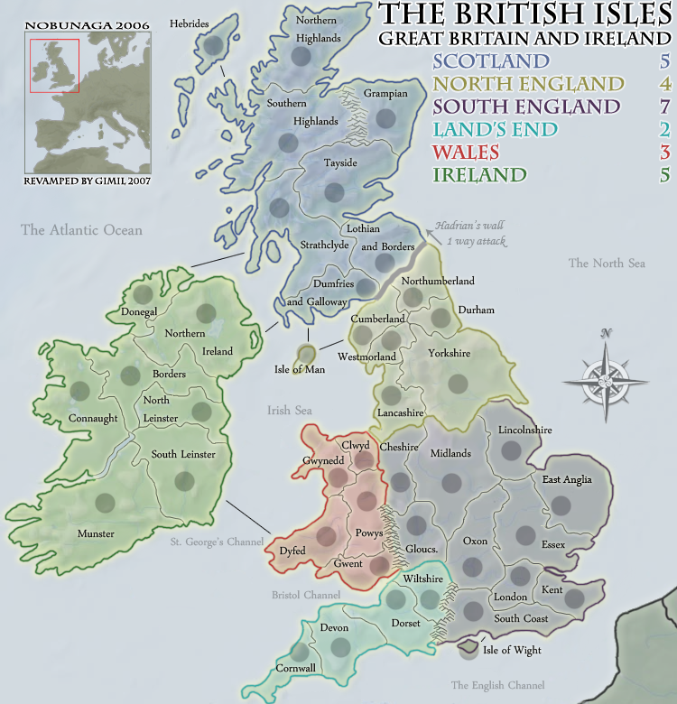
If i get no major quries by the next time im onlnie i will start the small version.
Posted: Sat Dec 15, 2007 5:18 am
by edbeard
it looks weird that the border on ireland, the river I guess, has a thin border whereas the rest of the island is thick green.
the connection between lancashire and clwyd doesn't look good with that gap. I'd suggest only having the yellow border. That way you have the continuity of only having one the yellow border next to both the red and purple.
also, there's a couple places that the purple borders are thicker than other parts. it just looks off.
any other ideas as to what to do with Hadrian's Wall? I just seems a little too simple. I know that's kinda the theme, but it just doesn't seem to work.
Posted: Sat Dec 15, 2007 1:32 pm
by AndyDufresne
I'm loving the graphic look of this map. I think it is becoming everything I hoped this map could be.
Few minor ideas: Perhaps move the legend names down a little...so there is a buffer space between "Great Britain and Ireland," as that is part of the title.
I'd also consider either adding more "The's" to the various water names or remove the ones from "The Atlantic Ocean," "The North Sea," and "The English Channel," so there is a uniformity.
I'd also maybe like to see a hint more of "yellow" in North England...so it doesn't look so close to Ireland (doesn't have any effect on gameplay, just for visual sake).
Otherwise it is looking good!
--Andy
Posted: Sat Dec 15, 2007 1:35 pm
by yeti_c
AndyDufresne wrote:
I'd also consider either adding more "The's" to the various water names or remove the ones from "The Atlantic Ocean," "The North Sea," and "The English Channel," so there is a uniformity.
Wha?!
YOu can't add an apostrophe into these names though!? They're real places!?
C.