I'm excited to see this map finished. It might become part of my map rotation.
--Andy
Golfe Du St. Laurent
Moderator: Cartographers
Forum rules
Please read the Community Guidelines before posting.
Please read the Community Guidelines before posting.
-
AndyDufresne

- Posts: 24932
- Joined: Fri Mar 03, 2006 8:22 pm
- Location: A Banana Palm in Zihuatanejo
- Contact:
-
Orange-Idaho-Dog

- Posts: 555
- Joined: Sun Jan 14, 2007 12:41 pm
- Gender: Male
- Location: South Carolina
Re: Golfe Du St. Laurent
Do these changes still need made, or not? I mentioned them back on page 2, I'm not sure if they were just overlooked or meant to stay the way they are.
Name fixes:
Avalon Penincula -> Avalon Peninsula
Grand Falls Winsor -> Grand Falls Windsor (GF-Windsor, on original map)
Name fixes:
Avalon Penincula -> Avalon Peninsula
Grand Falls Winsor -> Grand Falls Windsor (GF-Windsor, on original map)

Looking for a clan? Click here to send me a PM and find out how to join The Underworld! *Selective Recruitment*

Re: Golfe Du St. Laurent
It looks like the d made it onto the images in the first post, but "Peninsula" still needs a fix. I'd check the XML, but ripway is blocked here at work.

Re: Golfe Du St. Laurent
I've fixed it all, yes


Re: Golfe Du St. Laurent
Those look good. You should update the first post with those images.
It seems to me you are ready for the official XML check, but I don't recall the protocol. Do you submit when you feel ready, or do you wait for the Final Forge moderator(s) to invite you to do so?
It seems to me you are ready for the official XML check, but I don't recall the protocol. Do you submit when you feel ready, or do you wait for the Final Forge moderator(s) to invite you to do so?
Re: Golfe Du St. Laurent
forgot about that, thanks. (:ender516 wrote:Those look good. You should update the first post with those images.
It seems to me you are ready for the official XML check, but I don't recall the protocol. Do you submit when you feel ready, or do you wait for the Final Forge moderator(s) to invite you to do so?
-
Orange-Idaho-Dog
- Posts: 555
- Joined: Sun Jan 14, 2007 12:41 pm
- Gender: Male
- Location: South Carolina
Re: Golfe Du St. Laurent
All looks well to me, pending XML approval, I think it's beta time 
Looking for a clan? Click here to send me a PM and find out how to join The Underworld! *Selective Recruitment*
-
rdsrds2120

- Posts: 6274
- Joined: Fri Jul 03, 2009 3:42 am
- Gender: Male
Re: Golfe Du St. Laurent
Yes! Let's get this map started! Good work, Tisha!Orange-Idaho-Dog wrote:All looks well to me, pending XML approval, I think it's beta time
-rd
-
gimil

- Posts: 8599
- Joined: Sat Mar 03, 2007 12:42 pm
- Gender: Male
- Location: United Kingdom (Scotland)
Re: Golfe Du St. Laurent
Beautiful Tisha.
I remember when this map first came around. It is nice to see someone actually take it and get it to a point where it is ready to play.
Well done.
I remember when this map first came around. It is nice to see someone actually take it and get it to a point where it is ready to play.
Well done.
What do you know about map making, bitch?
Top Score:2403natty_dread wrote:I was wrong
-
AndyDufresne
- Posts: 24932
- Joined: Fri Mar 03, 2006 8:22 pm
- Location: A Banana Palm in Zihuatanejo
- Contact:
Re: Golfe Du St. Laurent
Agreement.gimil wrote:Beautiful Tisha.
I remember when this map first came around. It is nice to see someone actually take it and get it to a point where it is ready to play.
Well done.
--Andy


Re: Golfe Du St. Laurent
just a few notes on spelling and punctuation for both the images and the xml.
although Saint is often abbreviated in english-language place names, Saint John is always written in full to help to distinguish it from the newfoundland city of St John's.
http://www.saintjohn.ca/en/home/default.aspx
PEI is conventionally spelled without dots. the same rule is commonly used for all canadian province abbreviations.
http://www.gov.pe.ca/
the du in the title, Golfe du Saint-Laurent, ought to be in lower case only. it means of the, which is usually capitalised in neither english nor french. similarly with Est du Québec and Sud du Québec.
http://www.glf.dfo-mpo.gc.ca/f0006090
the above apart, u've done a splendid job with the graphics!
ian.

Re: Golfe Du St. Laurent
a little late on those, but alright.iancanton wrote:just a few notes on spelling and punctuation for both the images and the xml.
although Saint is often abbreviated in english-language place names, Saint John is always written in full to help to distinguish it from the newfoundland city of St John's.
http://www.saintjohn.ca/en/home/default.aspx
PEI is conventionally spelled without dots. the same rule is commonly used for all canadian province abbreviations.
http://www.gov.pe.ca/
the du in the title, Golfe du Saint-Laurent, ought to be in lower case only. it means of the, which is usually capitalised in neither english nor french. similarly with Est du Québec and Sud du Québec.
http://www.glf.dfo-mpo.gc.ca/f0006090
the above apart, u've done a splendid job with the graphics!
ian.
lowercase Du in the title doesn't look as great.
Re: Golfe Du St. Laurent
if the title looks a bit lopsided with a lower-case du, then keep the upper-case D in the title. because of its visual function, the title is one place where the artist always has some extra latitude.
ian.
ian.
-
thenobodies80

- Posts: 5400
- Joined: Wed Sep 05, 2007 4:30 am
- Gender: Male
- Location: Milan
Re: Golfe Du St. Laurent
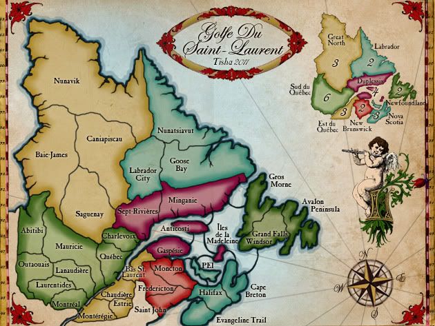
The map looks great, the only thing I'd like to suggest is to find a way to increase readability of few names. To be precise Anticosti, Bas St. Laurent, St. john and Grand Falls Windsor.
[edit] Also Chaudière looks weird on both versions, no way to have all the text on a single line?
[edit] Also Chaudière looks weird on both versions, no way to have all the text on a single line?
-
thenobodies80
- Posts: 5400
- Joined: Wed Sep 05, 2007 4:30 am
- Gender: Male
- Location: Milan
Re: Golfe Du St. Laurent
The xml is ok.


Re: Golfe Du St. Laurent
I cannot wait for this map to come out. Well done!
Highest Rank: 26 Highest Score: 3480

-
AndyDufresne
- Posts: 24932
- Joined: Fri Mar 03, 2006 8:22 pm
- Location: A Banana Palm in Zihuatanejo
- Contact:
Re: Golfe Du St. Laurent
Indeed, this looks like one I'd add to my list of play.
--Andy
--Andy
-
Industrial Helix

- Posts: 3462
- Joined: Mon Jul 14, 2008 6:49 pm
- Gender: Female
- Location: Ohio
Re: Golfe Du St. Laurent
Dying to play this one as well.
Sketchblog [Update 07/25/11]: http://indyhelixsketch.blogspot.com/
Living in Japan [Update 07/17/11]: http://mirrorcountryih.blogspot.com/
Russian Revolution map for ConquerClub [07/20/11]: http://www.conquerclub.com/forum/viewto ... 1&t=116575
Living in Japan [Update 07/17/11]: http://mirrorcountryih.blogspot.com/
Russian Revolution map for ConquerClub [07/20/11]: http://www.conquerclub.com/forum/viewto ... 1&t=116575

Re: Golfe Du St. Laurent
I've travelled most of it. I want to see if the scenery is as good as the real thing.
Bring out the beta please.
Bring out the beta please.

-
rdsrds2120
- Posts: 6274
- Joined: Fri Jul 03, 2009 3:42 am
- Gender: Male
Re: Golfe Du St. Laurent
On the large version, Grand Falls Windsor looks a little crooked. Can't wait! (:
-rd
-rd
Re: Golfe Du St. Laurent
Better?rdsrds2120 wrote:On the large version, Grand Falls Windsor looks a little crooked. Can't wait! (:
-rd
- Click image to enlarge.

-
rdsrds2120
- Posts: 6274
- Joined: Fri Jul 03, 2009 3:42 am
- Gender: Male
Re: Golfe Du St. Laurent
yeah , or at least I think so.
-rd
-rd