Page 1 of 1
Liechtenstein <V1.2>
Posted: Wed Jan 13, 2010 4:45 pm
by Boss_oss_ss
Hello All,
This is my first map so would like to hear peoples views on this:
I plan to do a map on Liechtenstein, one of the smallest countries in the world. As it is so small it only has a few towns, so i will include towns just accross the borders aswell.
I Have drawn a basic outline of what i would like to do:
Large:450X750
Version 1.2 With Roads
- Click image to enlarge.

Bonuses, Touch up roads and name places, Small map.
Version 1.0
http://i445.photobucket.com/albums/qq17 ... n/Lich.png
I will use this map as a guide to where to put the places
- Click image to enlarge.

I will have 24 Territories :
Lichtenstein:
Bangs
Balzers
Bendern
Schaanwald
Nendela
Ruggell
Schaan
Triesen
Triesenberg
Malbun
Vaduz
Total:11
Switzerland- To the Left
Lienz
Sennwald
Salez
Haag
Werdenberg
Buchs
Sevelen
Weite
Trübbach
Total:9
Austria - To the Right
Nofels
Feldkirch
Frastanz
Tisis
Total:4
I am planning to have the following bonuses:
Austria: +2
Switzerland: +5
Vaduz: +1
Vaduz, Feldkirch and Buchs: +2
Any thaughts?
Boss
Re: Liechtenstein <V1>
Posted: Wed Jan 13, 2010 5:47 pm
by natty dread
I could see this becoming a nice luxembourg style small map... go for it.
Re: Liechtenstein <V1>
Posted: Wed Jan 13, 2010 6:00 pm
by isaiah40
Darn someone beat me to the punch!

But I wholeheartedly agree with natty!! Go for it!!
Re: Liechtenstein <V1>
Posted: Wed Jan 13, 2010 7:41 pm
by fumandomuerte
Do you need 750px?
I think that you should reduce height size since it's a small map

Re: Liechtenstein <V1>
Posted: Thu Jan 14, 2010 2:24 am
by Boss_oss_ss
fumandomuerte wrote:Do you need 750px?
I think that you should reduce height size since it's a small map
The onny reason i have it soo large is so that all the detail on the map is clear and not all "Squashed in" when i downsize it.
I Will do a mock up of how i want it to look and if i feel it is too large i will edit it as needed.
Boss
Re: Liechtenstein <V1>
Posted: Sun Jan 17, 2010 11:42 am
by Boss_oss_ss
Anybody know the best way to draw roads on Serif Photoplus or GIMP? once i get that done it should be easy pickings

Boss
Re: Liechtenstein <V1>
Posted: Sun Jan 17, 2010 12:54 pm
by ManBungalow
Boss_oss_ss wrote:Anybody know the best way to draw roads on Serif Photoplus or GIMP? once i get that done it should be easy pickings
Boss
Using GIMP...
You can usually get the effect of a track/trail from a height using a standard fuzzy brush and drawing freehand:
- Click image to enlarge.

However, if you're after something that looks a little more sophisticated you could try something along these lines:
Draw your selection area to be the shape of the road:
- Click image to enlarge.

Then you can fill it with an existing pattern or cut your own image into the selection:
- Click image to enlarge.

When you sort out your selection area you can start feathering (Select -> Feather) and so on to make it look better.
If you want more help feel free to PM me and I'll do what I can.
Re: Liechtenstein <V1>
Posted: Sun Jan 17, 2010 5:44 pm
by Boss_oss_ss
Thanks ill have a try tommorow!
Boss
Re: Liechtenstein <V1.2>
Posted: Mon Jan 18, 2010 10:34 am
by Boss_oss_ss
Updated map first post, any thaughts??
Re: Liechtenstein <V1.2>
Posted: Mon Jan 18, 2010 11:04 am
by natty dread
What bothers me is... this is supposed to be a map of Liechtenstein, but half of the territories are outside Liechtenstein, while a major part of the country has no territories at all...
I'd suggest finding another way to divide it into territories, besides cities/towns.
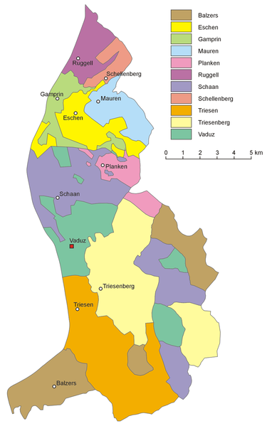
Look at this political map for example:
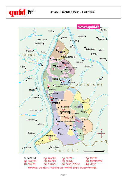
It has plenty of territories for a map, and then you would have regions instead of connector lines (trust me, I tried to make a map with cities connected by lines, and the majority of responses was "I'd like to see this map with proper borders & territories").
Just something to consider.
Re: Liechtenstein <V1.2>
Posted: Mon Jan 18, 2010 11:18 am
by Boss_oss_ss
natty_dread wrote:What bothers me is... this is supposed to be a map of Liechtenstein, but half of the territories are outside Liechtenstein, while a major part of the country has no territories at all...
I'd suggest finding another way to divide it into territories, besides cities/towns.
Look at this political map for example:
http://mappery.com/maps/Liechtenstein-R ... mb.pdf.png
It has plenty of territories for a map, and then you would have regions instead of connector lines (trust me, I tried to make a map with cities connected by lines, and the majority of responses was "I'd like to see this map with proper borders & territories").
Just something to consider.
That was another idea that i had, However, because there are so little towns, there are just as little regions. I was looking at maybe doing something similar to this:
, With regions including towns getting a bonus. what do you think of that?
[EDIT] same map but different site

[/EDIT]
Re: Liechtenstein <V1.2>
Posted: Mon Jan 18, 2010 11:20 am
by natty dread
Yes, that could work. Although that's a lot of small bonus regions. Maybe something like "+2 for every 3 towns" or something, in addition to a regular bonus structure.
Re: Liechtenstein <V1.2>
Posted: Mon Jan 18, 2010 11:23 am
by Boss_oss_ss
natty_dread wrote:Yes, that could work. Although that's a lot of small bonus regions. Maybe something like "+2 for every 3 towns" or something, in addition to a regular bonus structure.
Got ya
Re: Liechtenstein <V1.2>
Posted: Mon Jan 18, 2010 11:47 am
by Boss_oss_ss
Ive drawn out the map with regions: the only problem is how will i name the 3 regions highlighted With Wood! They are owned by different parts of the country and i cant really use the names twice


Re: Liechtenstein <V1.2>
Posted: Mon Jan 18, 2010 11:59 am
by natty dread
Be creative
Re: Liechtenstein <V1.2>
Posted: Mon Jan 18, 2010 12:07 pm
by Boss_oss_ss
natty_dread wrote:Be creative
Highlighting places with wood is about my creative limits
Ok ill think of something!
Re: Liechtenstein <V1.2>
Posted: Fri Jan 22, 2010 5:05 pm
by MrBenn
Personally I think you'll find it a really big struggle to make this work, with there being so few natural regions and towns to convert into CC territories

I don;t even know if there would be an easy way to incorporate any regional history or implications of tax evasion