
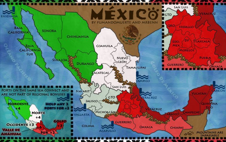
Mapmakers: MrBenn and fumandomuerte
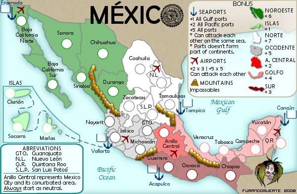
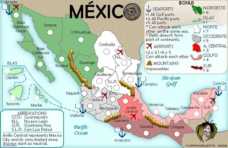
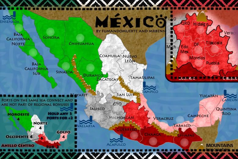
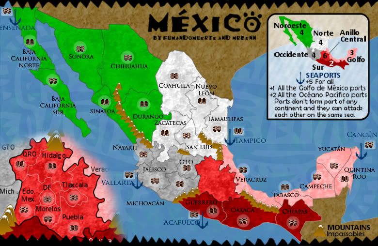
Territory Count: 30 starts + 5 neutral ports
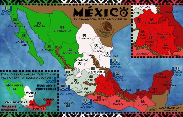
Bonuses: 6 regions
Gameplay: A map based on the actual political division of México with some important ports on both international waters. No new elements are added to the classical risk gameplay.
Foundry Stamps


Latest File Links
XML: http://www.fileden.com/files/2009/1/9/2 ... exico1.xml
Small Image: http://i275.photobucket.com/albums/jj32 ... ico14s.jpg
Large Image: http://i275.photobucket.com/albums/jj32 ... xico14.jpg
Latest Version - 11th September 2010
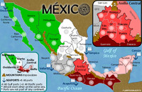
- Click image to enlarge.
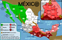
- Click image to enlarge.

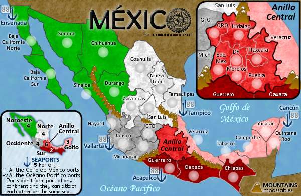
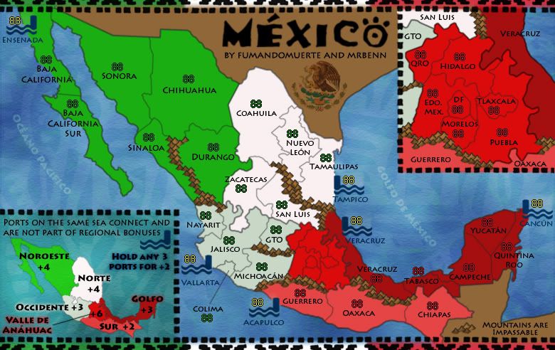
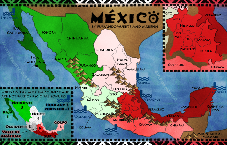
- Here are the (hopefully) final images!
- I've added some (more) texture to the coastline, darkened the border lines, and added a new texture to the land (which I still feel ambiguous about, but could live with this one).
Do people prefer this version or the previous version?
Small Map: http://i275.photobucket.com/albums/jj32 ... ico12S.jpg
Large Map: http://i275.photobucket.com/albums/jj32 ... ico12L.jpg
Yep - nothing quite looked right, and I like the contrast between the land and the water.The Bison King wrote:
He had texture on there earlier but had decided to remove it.natty_dread wrote:This is just me, but I wouldn't mind seeing a little bit of texture on the land.
Fixed them both; also joined up a line in the Central region on the main map, where I had removed a mountain at some pointthenobodies80 wrote:The only two things that i see are:
- finish the veracruz coast line in the top right inset
- Make better T letters in the phrase " ports on the same sea connect......" in the other inset
Voila....RedBaron0 wrote:and the small map.
Are we all done?
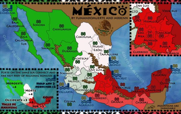
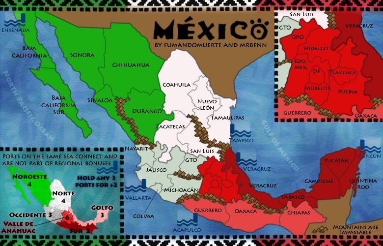
- Here's another quick update. I've made some minor tweaks to colours and some name placements. The sea names are now in Spanish too.
Previous Version - 6th August 2010
- I've played around with the colour scheme a little bit, and am happy with it the way it was originally (with some minor tweaks to the paler central regions).
- The mountains have been redrawn, and I'm actually quite happy with them, which makes a change for me - I've also filled in the gaps so it's much more obvious where the impassables actually are.
- The only obvious thing I can see that I still need to finalise is the minimap... unless anybody else can tell me otherwise?

Here are the changes:
- I've taken on board most of the suggestions; I've opened up the mountains between San Luis and Tamaulipas to make that area not so linear.
- The mountains between Michoacan and Edo. Mex. have similarly been removed to open up the Central region a little more.
- I've removed the Baja +1 bonus, and bumped Noroeste back up to 4, although I could be persuaded to drop it back down to three as it feels like it should be 3.5!
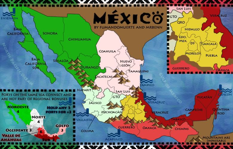
- Graphically, I've made the central area more yellow, and to be honest I preferred it red. The Eagle on the Mexico flag is much more brown than yellow, but brown looked even worse (and too similar to the unplayable areas).
- I've taken off the texture from the land, and actually like the sleek modern look it gives the map.
- As for the port icons, I really don't want to switch to an anchor; the icon I've designed doubles up really nicely as an army circle, and (in my opinion) fits the map quite nicely.
- I've had another look at the bonus regions, and think the map works slightly better with two in the middle. With that in mind, I've added in some more impassable mountains in sensible places, and tweaked some of the bonus values. Thoughts?
- The borders have more of a Mexican/Aztec feel to them now, and I've incorporated the colours from the national flag too. I've extended some of the mountain ranges towards the middle of the map, and have redrawn the Ports/Docks; I've tried to create a motif that vaguely fits the theme, but is distinctly port-esque.
To Do:
-The borders and Anillo Centro inset need to be redrawn; to make it more clear what goes where.
-Once the location of the mountains has been confirmed, they need to be redrawn to.
-It would be nice to add a third port on the West side to balance out the ports bonus.
Any and all feedback is welcome
- Here's my first update... I've resized to work on the large image first. Several of the layers had been flattened from fumandomuerte's working image, and I think he was using different software in any case.
The text layers were all rasterised, so I've taken the liberty of changing the font (it was very blurry when I resized it). I've added something of a traditional Mexican art feeling to the map by adding a border and and a motif to the sea texture. I think the sea now helps to lift the map a little.
I've moved the inset and minimap around, but still have a bit of work to do to get them up to scratch. Likewise, the mountains will need a bit of a revamp too.
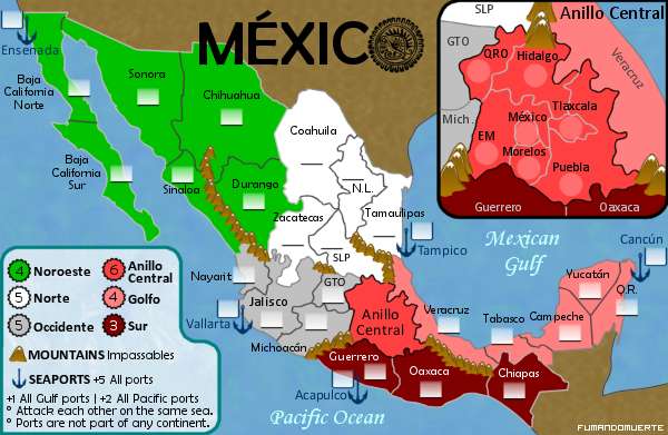
Before I spend too much time redoing graphics etc, I'd like to get the gameplay hammered out. The bonuses feel balanced between the North and the South, and I think the values are about right. What I'm not too keen on are the numbers of borders in/out of Anillo Centro (the red region on the inset). So, Discussion Requested = Gameplay
fumandomerte 1st post
Title: MEXICO
http://i462.photobucket.com/albums/qq35 ... /draft.png
A map based on the actual political division of México with some important ports on both international waters. No new elements are added to the classical risk gameplay.
VERSION 5 Updated 17/Mar/08
SMALL 600x391
30 Terits
5 Seaports
7 Continents
2 Sub continents
-Changed the bonus for the Anillo Central region from 5 to 6.
-Translated the sea names to the spanish form.
-Added some texture to the land.
-A little touch-up to some graphic elements like the terits names.
-The neutrals are shown (ports).
Is the gameplay OK or should I make a major change?
Have fun and keep coming to the map foundry, Vladi (fumandomuerte).
VERSION 4 (Small)
35 Territories
9 Continents (2 sub)
-Adjusted the bonuses.
-Added a mini-map for the bonuses.
-Renamed some terits:
EM > Edo. Mex.
México > DF
SL > San Luis
NL > Nuevo León
QR > Quintana Roo
VERSION 3 (Small)
6 Land Continents
2 Sub-continents
-Removed the airports.
-Brought back the "Anillo Central" zoom with detailed borders.
-Eliminated the isles system.
-Deleted the abbreviations box.
-Updated the bonus.
VERSION 2.1 (LARGE)
http://img120.imageshack.us/my.php?imag ... v22ci4.png
# Territories: 32
Seaports and anillo central start neutral.
-Fixed the border between Coahuila-Nuevo León (NL)-Tamaulipas
-Merged Colima, Aguascalientes (AGS.) & Jalisco into one territory named Jalisco.
-Made more legible territory names.
-Changed some graphical aspects such as the armies containers, the bonus frame and other stuff.
-Added a little mountain system to the border between Zacatecas-Guanajuato (GTO)-San Luis Potosi (SLP)-Jalisco to make easy to see who attacks who.
-Seaports keep starting neutral.
-Anillo central start neutral and with some extra defense (maybe 6).
-Got the XML, but lets wait more opinions and suggestions .
.
VERSION 2 (LARGE)
http://img513.imageshack.us/my.php?image=mexicolv21tl9.jpg
# Territories: 32
VERSION 1 (LARGE)
http://img530.imageshack.us/my.php?image=mexicolxl7.jpg
# Territories: 40
Ports start neutral
http://i462.photobucket.com/albums/qq35 ... /draft.png
A map based on the actual political division of México with some important ports on both international waters. No new elements are added to the classical risk gameplay.
VERSION 5 Updated 17/Mar/08
SMALL 600x391
- Click image to enlarge.
5 Seaports
7 Continents
2 Sub continents
-Changed the bonus for the Anillo Central region from 5 to 6.
-Translated the sea names to the spanish form.
-Added some texture to the land.
-A little touch-up to some graphic elements like the terits names.
-The neutrals are shown (ports).
Is the gameplay OK or should I make a major change?
Have fun and keep coming to the map foundry, Vladi (fumandomuerte).
VERSION 4 (Small)

35 Territories
9 Continents (2 sub)
-Adjusted the bonuses.
-Added a mini-map for the bonuses.
-Renamed some terits:
EM > Edo. Mex.
México > DF
SL > San Luis
NL > Nuevo León
QR > Quintana Roo
VERSION 3 (Small)

6 Land Continents
2 Sub-continents
-Removed the airports.
-Brought back the "Anillo Central" zoom with detailed borders.
-Eliminated the isles system.
-Deleted the abbreviations box.
-Updated the bonus.
VERSION 2.1 (LARGE)
http://img120.imageshack.us/my.php?imag ... v22ci4.png
# Territories: 32
Seaports and anillo central start neutral.
-Fixed the border between Coahuila-Nuevo León (NL)-Tamaulipas
-Merged Colima, Aguascalientes (AGS.) & Jalisco into one territory named Jalisco.
-Made more legible territory names.
-Changed some graphical aspects such as the armies containers, the bonus frame and other stuff.
-Added a little mountain system to the border between Zacatecas-Guanajuato (GTO)-San Luis Potosi (SLP)-Jalisco to make easy to see who attacks who.
-Seaports keep starting neutral.
-Anillo central start neutral and with some extra defense (maybe 6).
-Got the XML, but lets wait more opinions and suggestions
VERSION 2 (LARGE)
http://img513.imageshack.us/my.php?image=mexicolv21tl9.jpg
# Territories: 32
VERSION 1 (LARGE)
http://img530.imageshack.us/my.php?image=mexicolxl7.jpg
# Territories: 40
Ports start neutral


