What you need to know:
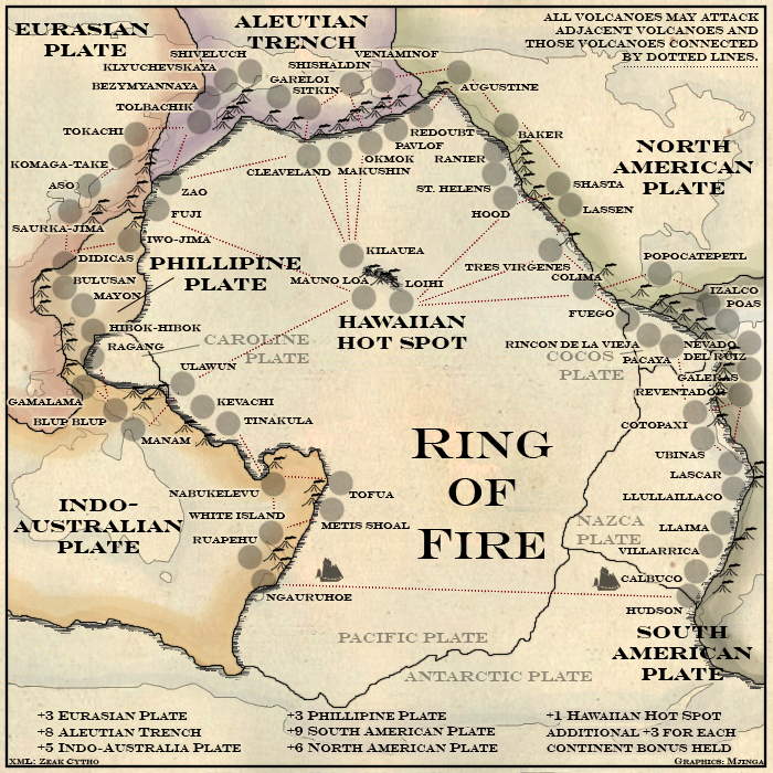
Number of territories: 66
Number of continents: 6
Gameplay Info: Classic gameplay, plus small additional bonus for holding Hawaii and extra continents.
-------------------------------------------------------------------------------------------------------------------------------------------------------
Hello again, peeps. Er, what to say... Another joint venture between ZeakCytho and myself. I made the map because Zeak made a joke about lolvolcanoes when we were discussing the (used to be) volcano on Bishan Island in our Archipelago map. I thought, Volcanoes! Über! And so, Ring of Fire was spawned.
Reputation cleared. Never let it be said that Team CC don't investigate fairly. Although they take bloody forever to do it...
For such a lucrative bonus as +3 for each additional continent, Hawaii needs to be much more accessible to the southern reaches of the map. Sure it might not be geographically correct, but unless you have Alcatraz-like accessibility, the bonus is imbalanced towards people who build up in the north.
As for the look, I'd prefer if you used some color in this map instead of a straight parchment look. Make the Ring of Fire sound like the RING OF FIRE [/echoes of Finding Nemo], instead of looking like a documentary from the 1800's.
greenoaks: Um, I admit to having based the style of the map off an old one by J Gibson, but that's an 1800s map and wasn't even of the Ring of Fire...
I'm also fairly certain that Zealandia is a submerged continent, not a plate.
t-o-m: Thanks!
TaCktiX: You're right about the bonus, I ought to change it. Which countries do you think ought to link to it? And... what kind of colour were you thinking?
Reputation cleared. Never let it be said that Team CC don't investigate fairly. Although they take bloody forever to do it...
Volcanoes that look like volcanoes, keep the land colored, but definitely water in the ocean. Nothing says Ring of Fire like lava flowing into the ocean, but that's a later stage in the map after the form is hammered out.
Mjinga wrote:greenoaks: Um, I admit to having based the style of the map off an old one by J Gibson, but that's an 1800s map and wasn't even of the Ring of Fire...
I'm also fairly certain that Zealandia is a submerged continent, not a plate.
isn't that the same thing
anyway new zealand is not apart of the australian plate. they are the other plate that we grind against.
greenoaks: Nope, different things. This site, where I got my information from, says that the part where I have volcanoes at is on the Indo-Australian Plate... it's the south part that's on the Pacific Plate, but I haven't got any volcanoes there.
bryguy: Thanks!
t-o-m: All territs are volcanoes. The names are by the army circles, so that it's easier to see how many troops are where, but all territs are volcanoes. The little volcano-icons show where they are geographically, and the army circles are placed as near to them as I can get them.
Reputation cleared. Never let it be said that Team CC don't investigate fairly. Although they take bloody forever to do it...
the place i was getting my information from had the south island of new zealand on the pacific side but it was only showing the ocean floor near the south island. i just assumed all of NZ was on the pacific plate.
i guess that means new zealand is part aussie, part pacific islander.
Is this map going to move forward a little bit more now that Archipelago is in the Main Foundry? I really like this idea a ton, and think you could run with it pretty far if you made the graphics less parchment-based.
TaCktiX wrote:Is this map going to move forward a little bit more now that Archipelago is in the Main Foundry? I really like this idea a ton, and think you could run with it pretty far if you made the graphics less parchment-based.
I have the feeling Mjinga got swallowed alive by her workload. I haven't seen her on MSN in a few days, though she hasn't missed any turns in the game I'm in with her. About a week ago, she told me she was working on another version of this, so with all hope, it'll be posted soon.
I agree with you about the parchment-graphics, but Mjinga said she liked it before. I guess she'll need to make a poll or something to decide which graphical theme to go with.
I like parchment-graphics with watercolor effects for continents.
I like the idea of seeing what's under pacific ocean, so without water!
But the names and circles position are quite a mess now, very difficult to see which is the name of which army circle and volcano and so the connections!
De gueules à la tour d'argent ouverte, crénelée de trois pièces, sommée d'un donjon ajouré, crénelé de deux pièces
Gules an open tower silver, crenellated three parts, topped by a apertured turret, crenellated two parts
TaChtiX: I’m gonna try! I recently got into grad school and stuff, so I’ve been bouncing off the walls recently. Very busy with work, too. Anyway…
I decided to not go for water and stuff because the continents all have their outlines in the water. The actual land-masses are scattered about inside the continent regions and I thought it’d be more confusing to have a blue contrast that suddenly ended inside territs.
pamoa: Thank you! I agree with you on the army circles in the crowded areas. Should I remove some? Should I make the connections bigger?
rgbubba: Thank you!
vonForster: How so?
jarrett155: I do, but I can’t fit all volcanoes, and I was going for the rather more famous ones.
I’ll put up an update sometime when I have more suggestions and/or I get an idea, but so far I’ve agreed that I need to add routes to Hawaii from the bottom of the map, is that right?
Reputation cleared. Never let it be said that Team CC don't investigate fairly. Although they take bloody forever to do it...
pamoa wrote:But the names and circles position are quite a mess now, very difficult to see which is the name of which army circle and volcano and so the connections!
you have to be more strict like volcano,circle,name or reverse order but do not alternate them in the same group. Maybe doing your map larger will help and if you need remove some volcanos. So if you stick to the rule above and maybe alternate the order between each group you will see them becoming clear evidence.
Also reorder bonus list in a logical order: eurasian, philippines, indo-australian / hawai / aleoutian, n. america, s. america.
Idea is really good but still need a lot of graphic work, go on!
De gueules à la tour d'argent ouverte, crénelée de trois pièces, sommée d'un donjon ajouré, crénelé de deux pièces
Gules an open tower silver, crenellated three parts, topped by a apertured turret, crenellated two parts
first, I love the parchment look. Much more effectively done here than in other places to be honest. What I would mainly do here is start manipulating reality a little. Make the volcanos larger, large enough to place the army circle in the base or something. And shift them to make it work. lava would be cool but like you say, water wouldn't work with the map style so I wouldn't worry about it. I'm liking this idea. keep it up!