whats a dash again?
if its the - , its probebly do to copying
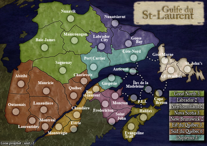
Golfe du St. Laurent[FD,G,GP,FF]
Moderator: Cartographers
Forum rules
Please read the Community Guidelines before posting.
Please read the Community Guidelines before posting.
-
Lone.prophet
- Posts: 1467
- Joined: Thu Oct 12, 2006 4:37 pm
- Location: Your basement Muahaha

Re: Golfe du St. Laurent (Lastest update p.26) [Final Forge]
yes those look a bit silly too and i'm not sure if they will have any negative effect on the XML itself but i'd leave them out.DiM wrote:i'm talking about the dashes
i don't know why you supposed i was wrting that XML file since mine look a lot better usually
- Click image to enlarge.

Re: Golfe du St. Laurent (Lastest update p.26) [Final Forge]
oh you're right indeed, i was a bit sleepy while writing that i guessyeti_c wrote:Hmmm - This is incorrect information I'm afraid!zimmah wrote:i dind't really check the XML but i think DiM refers to the <XML version> tag being in the first line while the MAP tag is on the second line, it should be the complete opposite of that.
C.
- Click image to enlarge.
-
DiM

- Posts: 10415
- Joined: Wed Feb 14, 2007 6:20 pm
- Gender: Male
- Location: making maps for scooby snacks
Re: Golfe du St. Laurent (Lastest update p.26) [Final Forge]
Lone.prophet wrote:whats a dash again?
if its the - , its probebly do to copying
that's the dash.
and i know it's because of copying that's why i asked unit if he copied the xml
“In the beginning God said, the four-dimensional divergence of an antisymmetric, second rank tensor equals zero, and there was light, and it was good. And on the seventh day he rested.”- Michio Kaku
Re: Golfe du St. Laurent (Lastest update p.26) [Final Forge]
he might have copied it, but i didn't write it.DiM wrote:Lone.prophet wrote:whats a dash again?
if its the - , its probebly do to copying
that's the dash.
and i know it's because of copying that's why i asked unit if he copied the xml
- Click image to enlarge.
-
Lone.prophet
- Posts: 1467
- Joined: Thu Oct 12, 2006 4:37 pm
- Location: Your basement Muahaha
Re: Golfe du St. Laurent (Lastest update p.26) [Final Forge]
i mean copying in the browser, i had the same problem when i wanted to show the xml

Re: Golfe du St. Laurent (Lastest update p.26) [Final Forge]
either open the xml in notepad and then copy/paste it or put it online and paste the link here. and you won't have that problem.
- Click image to enlarge.
-
Lone.prophet
- Posts: 1467
- Joined: Thu Oct 12, 2006 4:37 pm
- Location: Your basement Muahaha
Re: Golfe du St. Laurent (Lastest update p.26) [Final Forge]
ahh it doesnt matter huh
dont mind the letters they will go back to old style
dont mind the letters they will go back to old style
-
Unit_2

- Posts: 1834
- Joined: Sun Jan 14, 2007 12:59 pm
- Gender: Male
- Location: Pennsylvania, U.S.A, North America, Earth, Milky Way, Universe.
Re: Golfe du St. Laurent (Lastest update p.26) [Final Forge]
Its not copied, I uploaded it to Ripway and it add's them in.

-
Ruben Cassar
- Posts: 2160
- Joined: Thu Nov 16, 2006 6:04 am
- Gender: Male
- Location: Civitas Invicta, Melita, Evropa
Re: Golfe du St. Laurent (Lastest update p.26) [Final Forge]
Really? You're a French speaker and you don't see the spelling mistake? Hehe.Gilles#1 wrote:Good job
It should be "Golfe du Saint-Laurent" Lone. Just copy and paste it mate.


Re: Golfe du St. Laurent (Lastest update p.26) [Final Forge]
No - viewing it from a browser does that... you should copy and paste from the source file not the uploaded one.Unit_2 wrote:Its not copied, I uploaded it to Ripway and it add's them in.
C.

Highest score : 2297
Re: Golfe du St. Laurent (Lastest update p.26) [Final Forge]
They change the name on subject but yhey have to do on the map, he know that. 
-
Lone.prophet
- Posts: 1467
- Joined: Thu Oct 12, 2006 4:37 pm
- Location: Your basement Muahaha
Re: Golfe du St. Laurent (Lastest update p.26) [Final Forge]
he wrote Gulfe du St-Laurent on the map while it should be Golfe du St. Laurent or Golfe du Saint-Laurent (either Saint- or St., but not St-) and either Gulf of or Golfe du, but not Gulfe duLone.prophet wrote:why cant "saint" be "st"?
i think that's what he means by spelling mistakes, he's mixing them up.
- Click image to enlarge.
Re: Golfe du St. Laurent (Lastest update p.26) [Final Forge]
Please use Golfe du St-Laurent
-
Lone.prophet
- Posts: 1467
- Joined: Thu Oct 12, 2006 4:37 pm
- Location: Your basement Muahaha
-
Ruben Cassar
- Posts: 2160
- Joined: Thu Nov 16, 2006 6:04 am
- Gender: Male
- Location: Civitas Invicta, Melita, Evropa
Re: Golfe du St. Laurent (Lastest update p.26) [Final Forge]
Ok seems like my message got through in the end.Lone.prophet wrote:ahh ok will do
Another thing I'm just noticing. The white text is very hard to read on Newfoundland. Perhaps adding a 1pt dark stroke to the font could make the text more legible?
Apart from that it's looking great. Good job Lone!
Re: Golfe du St. Laurent (Lastest update p.26) [Final Forge]
St. Laurent still looks better IMHO.Gilles#1 wrote:Please use Golfe du St-Laurent
- Click image to enlarge.

Re: Golfe du St. Laurent (Lastest update p.26) [Final Forge]
yep.yeti_c wrote:No - viewing it from a browser does that... you should copy and paste from the source file not the uploaded one.Unit_2 wrote:Its not copied, I uploaded it to Ripway and it add's them in.
C.
When I checked yours (a day or two ago), unit, after removing the dashes, I still had errors because of the special characters. I think there's another line that needs to be added so these characters work. Though, I'm the wrong person to ask about that. Perhaps the characters need to be coded in a different way. I'd look at the iceland thread if I were you. They talk about it in there.
Perhaps when I removed the dashes I also inadvertently erased that line (though that seems a bit far fetched).
When this is fixed I'll give the XML a quick run through.


Re: Golfe du St-Laurent (Lastest update p.1) [Final Forge]
thanks for the update lone.prophet. we're now more than halfway there. are u waiting for unit_2's opinion on Manicouagan? i link again to the image below.
http://farm4.static.flickr.com/3207/246 ... 25.jpg?v=0
http://www.tourismemanicouagan.com/en/carte.asp
other things still on my previous list are below.
the Îles de la Madeleine islands are part of the same administrative region as Gaspésie, so i propose drawing a sea route to Gaspésie.
http://www.mdeie.gouv.qc.ca/index.php?id=3920
i propose removing the sea route between Îles de la Madeleine and Anticosti. the effect is to let strategy play a greater role by making the Gulf of St Lawrence more difficult to cross from north to south.
lone.prophet, i mentioned previously that the sea routes look a bit untidy. can u try using smaller dots that are closer together?
Baie-James ought to border Mauricie, as seen on the map below.
http://www.inforoutiere.qc.ca/fr/carte_ ... /index.asp
Bas st-laurent is supposed to be Bas St-Laurent (capital letter for the first letter of each word).
http://www.bas-saint-laurent.org/English
i also propose that Nova Scotia continent becomes Nova Scotia & PEI, to acknowledge that PEI is a separate province without changing the gameplay.
ian.
http://farm4.static.flickr.com/3207/246 ... 25.jpg?v=0
unit_2, in my previous update request, i proposed merging Port Cartier with Manicouagan and making the merged territory part of Duplessis continent. this is because, as u can see on the webpage below, Manicouagan is in the wrong place and ought to be where Port Cartier currently is. are u happy with this change?iancanton wrote:merge Manicouagan with Port Cartier and draw merged territory with a straight western border.
http://www.tourismemanicouagan.com/en/carte.asp
other things still on my previous list are below.
an explanation for each change is given below.iancanton wrote:draw sea route between Îles de la Madeleine and Gaspésie.
remove sea route between Îles de la Madeleine and Anticosti.
for sea routes, try using smaller dots that are closer together.
change Baie-James border so that it borders Mauricie.
rename Bas st-laurent as Bas St-Laurent.
rename Nova Scotia as Nova Scotia & PEI.
the Îles de la Madeleine islands are part of the same administrative region as Gaspésie, so i propose drawing a sea route to Gaspésie.
http://www.mdeie.gouv.qc.ca/index.php?id=3920
i propose removing the sea route between Îles de la Madeleine and Anticosti. the effect is to let strategy play a greater role by making the Gulf of St Lawrence more difficult to cross from north to south.
lone.prophet, i mentioned previously that the sea routes look a bit untidy. can u try using smaller dots that are closer together?
Baie-James ought to border Mauricie, as seen on the map below.
http://www.inforoutiere.qc.ca/fr/carte_ ... /index.asp
Bas st-laurent is supposed to be Bas St-Laurent (capital letter for the first letter of each word).
http://www.bas-saint-laurent.org/English
i also propose that Nova Scotia continent becomes Nova Scotia & PEI, to acknowledge that PEI is a separate province without changing the gameplay.
ian.
-
Unit_2
- Posts: 1834
- Joined: Sun Jan 14, 2007 12:59 pm
- Gender: Male
- Location: Pennsylvania, U.S.A, North America, Earth, Milky Way, Universe.
Re: Golfe du St. Laurent (Lastest update p.26) [Final Forge]
I beleave there is nothing more that needs done, I don't like the gameplay or borders with yours Iam(no offence), but if we redid it we would have to get the gameplay stamp again.
I'ved looked into the names and I don't see it fit to change them either.
I'ved looked into the names and I don't see it fit to change them either.
-
Ruben Cassar
- Posts: 2160
- Joined: Thu Nov 16, 2006 6:04 am
- Gender: Male
- Location: Civitas Invicta, Melita, Evropa
Re: Golfe du St. Laurent (Lastest update p.26) [Final Forge]
What about this? I think this definitely needs looking into.Unit_2 wrote:I beleave there is nothing more that needs done, I don't like the gameplay or borders with yours Iam(no offence), but if we redid it we would have to get the gameplay stamp again.
I'ved looked into the names and I don't see it fit to change them either.
Ruben Cassar wrote: Another thing I'm just noticing. The white text is very hard to read on Newfoundland. Perhaps adding a 1pt dark stroke to the font could make the text more legible?
Re: Golfe du St. Laurent (Lastest update p.26) [Final Forge]
unit_2
i realise that u want the map to be finalised quickly. however, it is not ready to be quenched because there are errors to be corrected.
point accepted on changing the Îles de la Madeleine to Anticosti sea route.
http://www.inforoutiere.qc.ca/fr/carte_ ... /index.asp
http://www.stat.gouv.qc.ca/regions/prof ... _00_an.htm
http://www.tourismemanicouagan.com/en/carte.asp
Bas St-Laurent is supposed to have three capital letters. this is beyond reasonable dispute.
i also ask for Nova Scotia continent to be renamed Nova Scotia & PEI to acknowledge that the continent is made up of two separate provinces (which have been combined for gameplay purposes). i believe this does not cause difficulties for anyone.
ian.
i realise that u want the map to be finalised quickly. however, it is not ready to be quenched because there are errors to be corrected.
Unit_2 wrote:I don't like the gameplay
point accepted on merging Port Cartier with Manicouagan.Unit_2 wrote:if we redid it we would have to get the gameplay stamp again.
point accepted on changing the Îles de la Madeleine to Anticosti sea route.
Baie-James does actually border Mauricie. this is fact, not opinion. look at the map that is linked below. it is a very minor gameplay change that leaves each continent with the same number of borders and has so little practical effect that there is no reason why it will affect the gameplay stamp. it is simply a change that corrects an error.Unit_2 wrote:or borders
http://www.inforoutiere.qc.ca/fr/carte_ ... /index.asp
Manicouagan is in the wrong place. the territory that u have called Manicouagan is not actually Manicouagan: if u want to retain the territory instead of merging it, then the correct name is Caniapiscau. the real Manicouagan administrative region is located where u have put Port Cartier. again, this is fact, not opinion, and i refer u to the maps below.Unit_2 wrote:I'ved looked into the names and I don't see it fit to change them either.
http://www.stat.gouv.qc.ca/regions/prof ... _00_an.htm
http://www.tourismemanicouagan.com/en/carte.asp
Bas St-Laurent is supposed to have three capital letters. this is beyond reasonable dispute.
i also ask for Nova Scotia continent to be renamed Nova Scotia & PEI to acknowledge that the continent is made up of two separate provinces (which have been combined for gameplay purposes). i believe this does not cause difficulties for anyone.
ian.
-
Lone.prophet
- Posts: 1467
- Joined: Thu Oct 12, 2006 4:37 pm
- Location: Your basement Muahaha
Re: Golfe du St. Laurent (Lastest update p.26) [Final Forge]
uhmm about the text i didnt unhide the outline but it will be like it was