[Official] Germany Revamp
Moderator: Cartographers
Forum rules
Please read the Community Guidelines before posting.
Please read the Community Guidelines before posting.
-
multiplayertim
- Posts: 339
- Joined: Sat May 12, 2007 5:11 pm
- Location: Munster
Re: [Official] Germany REVAMP - New Update 7/10 Pg. 10 [I, Gp]
i started a topic in the German speaking forum under "neues Deutschen-Karte" if you want to post an image of the thread there or make a comment
Winner: Tournament of the Minds
-
pepperonibread

- Posts: 954
- Joined: Sun Jan 28, 2007 4:33 pm
- Location: The Former Confederacy
Re: [Official] Germany REVAMP - New Update 7/10 Pg. 10 [I, Gp]
Thanks for the topic in the German forum tim. Hopefully we can get some more good discussion going here.
Anyway guys, got a new update here. It's only been like a month:
Large:

Large w/ Army #'s:
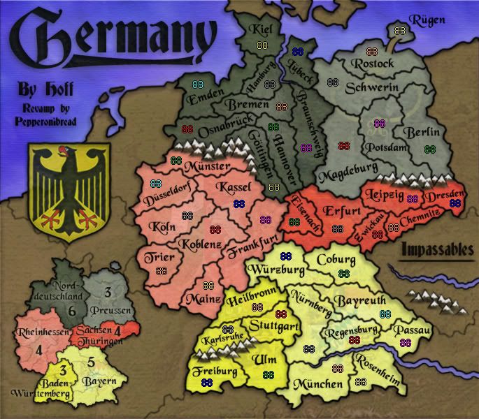
Changes:
-Redrew the dead land to better reflect the Netherlands coast.
-Removed the German motto from the top of the coat of arms. I tried to add it in a few other places, but so far I haven't found anything I think works better than leaving it out. If you guys really think the map needs it though, i can probably add it back somewhere.
-Erased the leftmost section of the river bordering the territory Kiel, as it didn't actually block any attacks.
-Added and rearranged mountains to clarify which territories can attack each other. I also experimented with some effects on the mountains; they're now a bit darker and look slightly different.
-Increased the saturation on the yellows in the coat of arms and also in the continent of Baden-Wurttemberg. This helps them stand out a bit more, and also accentuates the difference between the two yellow continents.
-Adjusted the minimap to reflect the other changes.
To-do:
-More discussion on accuracy? Looks like there might still be a ways to go on this front.
-Comments?
Anyway guys, got a new update here. It's only been like a month:
Large:
Large w/ Army #'s:
Changes:
-Redrew the dead land to better reflect the Netherlands coast.
-Removed the German motto from the top of the coat of arms. I tried to add it in a few other places, but so far I haven't found anything I think works better than leaving it out. If you guys really think the map needs it though, i can probably add it back somewhere.
-Erased the leftmost section of the river bordering the territory Kiel, as it didn't actually block any attacks.
-Added and rearranged mountains to clarify which territories can attack each other. I also experimented with some effects on the mountains; they're now a bit darker and look slightly different.
-Increased the saturation on the yellows in the coat of arms and also in the continent of Baden-Wurttemberg. This helps them stand out a bit more, and also accentuates the difference between the two yellow continents.
-Adjusted the minimap to reflect the other changes.
To-do:
-More discussion on accuracy? Looks like there might still be a ways to go on this front.
-Comments?


Re: [Official] Germany REVAMP - New Update 8/9 Pg. 12 [I, Gp]
did you try putting all the darker colours on one side yet?
-
pepperonibread
- Posts: 954
- Joined: Sun Jan 28, 2007 4:33 pm
- Location: The Former Confederacy
Re: [Official] Germany REVAMP - New Update 8/9 Pg. 12 [I, Gp]
Here ya go:
A.
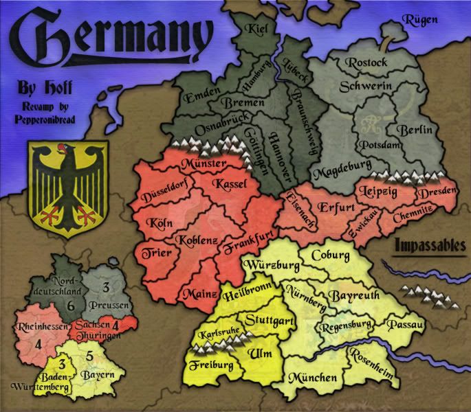
B.
Of these two, I think I like B the best, as the saturated continents on the right balance out the strong title, minimap, and sea on the left.
A.
B.
Of these two, I think I like B the best, as the saturated continents on the right balance out the strong title, minimap, and sea on the left.

Re: [Official] Germany REVAMP - New Update 8/9 Pg. 12 [I, Gp]
I like B, with all the strong colors on the right.
Also, I think you need one more mountain between Karlsruhe and Freiburg on the far left of the mountain range.
Also, I think you need one more mountain between Karlsruhe and Freiburg on the far left of the mountain range.

Re: [Official] Germany REVAMP- Update/Possible Colors P.12[I,Gp]
B for me. Looking good. 

* Pearl Harbour * Waterloo * Forbidden City * Jamaica * Pot Mosbi
-
sam_levi_11

- Posts: 2872
- Joined: Mon Dec 11, 2006 2:48 pm
- Gender: Male
Re: [Official] Germany REVAMP- Update/Possible Colors P.12[I,Gp]
b is the most balanced
-
pepperonibread
- Posts: 954
- Joined: Sun Jan 28, 2007 4:33 pm
- Location: The Former Confederacy
Re: [Official] Germany REVAMP- Update/Possible Colors P.12[I,Gp]
And B wins by a landslide. New update:
Large:
Large w/ Army #'s:

Changes:
-Tweaked color scheme so all saturated colors are on one side of the map, to better balance out the image. Adjusted the minimap accordingly.
-Shifted some mountains to make clear that Karlsruhe and Freiburg do not border.
To-do:
-Comments?
Large:
Large w/ Army #'s:
Changes:
-Tweaked color scheme so all saturated colors are on one side of the map, to better balance out the image. Adjusted the minimap accordingly.
-Shifted some mountains to make clear that Karlsruhe and Freiburg do not border.
To-do:
-Comments?
-
whitestazn88
- Posts: 3128
- Joined: Mon Feb 05, 2007 2:59 pm
- Gender: Male
- Location: behind you
- Contact:
Re: [Official] Germany REVAMP 8/13 Update Pgs. 1&13 [I, Gp]
his looks great
-
Incandenza

- Posts: 4949
- Joined: Thu Oct 19, 2006 5:34 pm
- Gender: Male
- Location: Playing Eschaton with a bucket of old tennis balls
Re: [Official] Germany REVAMP 8/13 Update Pgs. 1&13 [I, Gp]
Looking damn good, pep. But (and you knew there was a "but" coming...), there's one thing that kinda bugs me.
Forgive me if this has already been hashed over, but it seems like there's a more elegant way of dealing with the elongation of koblenz. Just seems like an impassable between mainz and trier would be a better, more visually appealing solution. As it stands, the terit looks kinda weird, and koblenz isn't exactly the sort of burgeoning metropolis that on its own would warrant such an acreage.
Forgive me if this has already been hashed over, but it seems like there's a more elegant way of dealing with the elongation of koblenz. Just seems like an impassable between mainz and trier would be a better, more visually appealing solution. As it stands, the terit looks kinda weird, and koblenz isn't exactly the sort of burgeoning metropolis that on its own would warrant such an acreage.
THOTA: dingdingdingdingdingdingBOOM
Te Occidere Possunt Sed Te Edere Non Possunt Nefas Est
Te Occidere Possunt Sed Te Edere Non Possunt Nefas Est
-
pepperonibread
- Posts: 954
- Joined: Sun Jan 28, 2007 4:33 pm
- Location: The Former Confederacy
Re: [Official] Germany REVAMP - DRAFT of New Borders Pg. 5
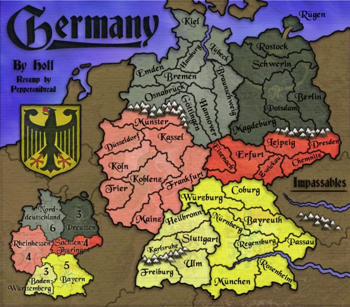
Well, here's the other option:Incandenza wrote:Looking damn good, pep. But (and you knew there was a "but" coming...), there's one thing that kinda bugs me.
Forgive me if this has already been hashed over, but it seems like there's a more elegant way of dealing with the elongation of koblenz. Just seems like an impassable between mainz and trier would be a better, more visually appealing solution. As it stands, the terit looks kinda weird, and koblenz isn't exactly the sort of burgeoning metropolis that on its own would warrant such an acreage.

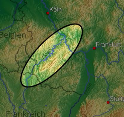
This is a draft from when there was still a lot of border tweaking to be done. Koblenz (Siegen on this map) was separated from the edge of the country by the Rhine, and Trier and Mainz (Pfalz on this map) are separated from each other by the Moselle River. The reason for using the configuration I have now is simply because I didn't want six or seven bridges spanning the continent. Now, I could just use the Moselle River and leave the Rhine out of it, but it ends slightly below the "Thuringen" on the minimap. So, the river would have no mouth, which is bad for two reasons: first, because it wouldn't look good with my style of rivers, that slowly slim down, and second, because people usually like rivers to be as realistic as possible.
So there's my argument. A few interesting looking territories isn't too bad I think anyway. Any suggestions to fix this though are of course appreciated
-
Incandenza
- Posts: 4949
- Joined: Thu Oct 19, 2006 5:34 pm
- Gender: Male
- Location: Playing Eschaton with a bucket of old tennis balls
Re: [Official] Germany REVAMP 8/13 Update Pgs. 1&13 [I, Gp]
You're right to not want a bunch of bridges, and I see your point about how the Moselle wouldn't look great...
I dunno, I don't imagine there's a handy set of hills/mountains in the area.
It's not a huge deal, I guess. I can appreciate the fact that you've clearly done your due diligence.
I dunno, I don't imagine there's a handy set of hills/mountains in the area.
It's not a huge deal, I guess. I can appreciate the fact that you've clearly done your due diligence.
THOTA: dingdingdingdingdingdingBOOM
Te Occidere Possunt Sed Te Edere Non Possunt Nefas Est
Te Occidere Possunt Sed Te Edere Non Possunt Nefas Est
Re: [Official] Germany REVAMP 8/13 Update Pgs. 1&13 [I, Gp]
Have I mentioned that I'm unable to play the Germany map as it is now after seeing the amazing graphics on this revamp? Hurry up and quench!
As for the "problem" with Klobenz, adding a semi-fictional mountain range is out of the question? It seems to me that most of the mountains you have are already somewhat fictionalized, as there are no high alpine peaks in the north of Germany, or, at least as far as I, an American, know of. I think most of the Germans on the site would probably prefer more realistic territory divisions than geographic elements?
As for the "problem" with Klobenz, adding a semi-fictional mountain range is out of the question? It seems to me that most of the mountains you have are already somewhat fictionalized, as there are no high alpine peaks in the north of Germany, or, at least as far as I, an American, know of. I think most of the Germans on the site would probably prefer more realistic territory divisions than geographic elements?
-
pepperonibread
- Posts: 954
- Joined: Sun Jan 28, 2007 4:33 pm
- Location: The Former Confederacy
Re: [Official] Germany REVAMP 8/13 Update Pgs. 1&13 [I, Gp]
So I did a bit more research, and lo and behold, look what I found:
The Hunsrück mountains. Not the highest mountains in Germany, but neither are those bordering Munster. So I think this basically solves the problem. I'll rearrange the territ. borders for the next update.
Wow, I hate doing these mountains. Only for you guys
The Hunsrück mountains. Not the highest mountains in Germany, but neither are those bordering Munster. So I think this basically solves the problem. I'll rearrange the territ. borders for the next update.
Wow, I hate doing these mountains. Only for you guys
Re: [Official] Germany REVAMP 8/13 Update Pgs. 1&13 [I, Gp]
As I think I've asked before.....if you're going to re-arrange something....why can't the Rhine be included in this map to make it more accurate. I think it is sacrilege to leave the Rhine out of a map of Germany, especially when it divides those territories.
* Pearl Harbour * Waterloo * Forbidden City * Jamaica * Pot Mosbi
-
pepperonibread
- Posts: 954
- Joined: Sun Jan 28, 2007 4:33 pm
- Location: The Former Confederacy
Re: [Official] Germany REVAMP 8/13 Update Pgs. 1&13 [I, Gp]
Well, like I said a few posts ago, adding the Rhine really doesn't block anything and just necessitates a bunch of bridges. It's only real function would be to give a mouth to the Moselle River, which would actually be an impassable. Seeing how this would just clutter up the map, I think we have a good solution in the Hunsrück Mts I mentioned above.cairnswk wrote:As I think I've asked before.....if you're going to re-arrange something....why can't the Rhine be included in this map to make it more accurate. I think it is sacrilege to leave the Rhine out of a map of Germany, especially when it divides those territories.

Re: [Official] Germany REVAMP 8/13 Update Pgs. 1&13 [I, Gp]
Pep.... congratulations!
This map looks fantastic. You've created a completely unique feeling map, that's easy on the eyes and feels German. My only comment is the faint image in the background of the map. I can barely see what it is (in fact I really cant). Is there a reason for it (I haven't went back to read all the pages). Also - I personally think your minimap would look better without the territory borders on it. Just keep the main bonus region borders.
This map looks fantastic. You've created a completely unique feeling map, that's easy on the eyes and feels German. My only comment is the faint image in the background of the map. I can barely see what it is (in fact I really cant). Is there a reason for it (I haven't went back to read all the pages). Also - I personally think your minimap would look better without the territory borders on it. Just keep the main bonus region borders.

-
pepperonibread
- Posts: 954
- Joined: Sun Jan 28, 2007 4:33 pm
- Location: The Former Confederacy
Re: [Official] Germany REVAMP 8/13 Update Pgs. 1&13 [I, Gp]
You mean an image on the actual map, not the whole image? That would be the coats of arms for each continent (think Great Lakes). People seem to be split on this, some love them, others think they look like crap. Taking the middle road I guess doesn't work too well either, as you can't even tell what they are. So I'm thinking this may have to come to a vote, with my own judgment if it's too close.RjBeals wrote:Pep.... congratulations!
This map looks fantastic. You've created a completely unique feeling map, that's easy on the eyes and feels German. My only comment is the faint image in the background of the map. I can barely see what it is (in fact I really cant). Is there a reason for it (I haven't went back to read all the pages). Also - I personally think your minimap would look better without the territory borders on it. Just keep the main bonus region borders.
A can-do on the minimap suggestion. Thanks for the praise RJ, it means a bunch coming from you.
-
Arachnophobia
- Posts: 43
- Joined: Fri Feb 23, 2007 8:23 pm
- Location: Berlin, Germany
Re: [Official] Germany REVAMP 8/13 Update Pgs. 1&13 [I, Gp]
hiho again, got one lil proposal:
Change Emden to Bremerhaven. That way you got an explanation why Bremen is landlocked (which is actually a port city from back in the Hanse days, seatrade was very important for the development of the city) and the territory of Emden streches so far east and north when its actually on the most western side of germany...
apart from that, the rivers and mountains are all not really realistic so I doubt we have a dire need to change a few of them when we dont change all. Im all for adding the mountain range between Trier and Mainz. That would actually be one of the most realistic impassables on the map
Also im all for the coat of arms, although you could make them a tad more visible (esspecially for Norddeutschland and Sachsen-Thüringen, these are neary invisible). You could leave them out on the minimap though
-
pepperonibread
- Posts: 954
- Joined: Sun Jan 28, 2007 4:33 pm
- Location: The Former Confederacy
Re: [Official] Germany REVAMP 8/13 Update Pgs. 1&13 [I, Gp]
Everything sounds fine to me. Thanks arachnophobiaArachnophobia wrote:hiho again, got one lil proposal:
Change Emden to Bremerhaven. That way you got an explanation why Bremen is landlocked (which is actually a port city from back in the Hanse days, seatrade was very important for the development of the city) and the territory of Emden streches so far east and north when its actually on the most western side of germany...
apart from that, the rivers and mountains are all not really realistic so I doubt we have a dire need to change a few of them when we dont change all. Im all for adding the mountain range between Trier and Mainz. That would actually be one of the most realistic impassables on the map
Also im all for the coat of arms, although you could make them a tad more visible (esspecially for Norddeutschland and Sachsen-Thüringen, these are neary invisible). You could leave them out on the minimap though
Re: [Official] Germany REVAMP 8/13 Update Pgs. 1&13 [I, Gp]
Any update on this one coming pepperonibread?
* Pearl Harbour * Waterloo * Forbidden City * Jamaica * Pot Mosbi
-
pepperonibread
- Posts: 954
- Joined: Sun Jan 28, 2007 4:33 pm
- Location: The Former Confederacy
Re: [Official] Germany REVAMP 8/13 Update Pgs. 1&13 [I, Gp]
Not to worry cairns. Just finished my last summer essay, so I should be able to get an update in between now and school starting
Re: [Official] Germany REVAMP 8/13 Update Pgs. 1&13 [I, Gp]
Thanks mate.pepperonibread wrote:Not to worry cairns. Just finished my last summer essay, so I should be able to get an update in between now and school starting
* Pearl Harbour * Waterloo * Forbidden City * Jamaica * Pot Mosbi

Re: [Official] Germany REVAMP 8/13 Update Pgs. 1&13 [I, Gp]
NOOooooooooo Pep - I hope you've not abandoned this - it's so close (if not ready)?!
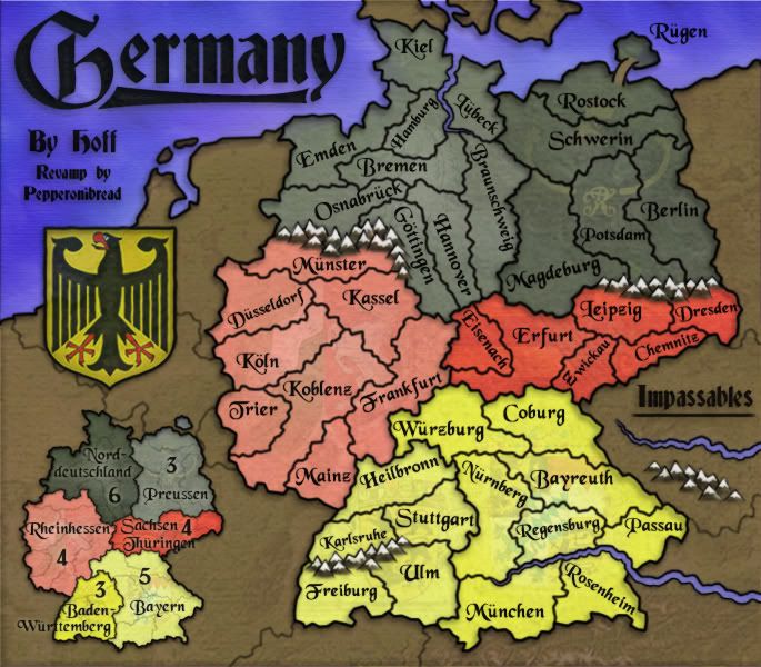
C.
C.

Highest score : 2297