
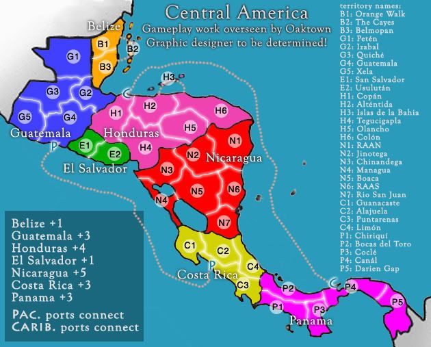
Them islands numbered up as H3 - they're part of Honduras? - If so why are they Cyan and Not pink?
C.
Central America - gameplay discussion thread
Moderator: Cartographers
Forum rules
Please read the Community Guidelines before posting.
Please read the Community Guidelines before posting.
Re: Central America: A Group Project, ver 4

Highest score : 2297

Re: Central America: A Group Project, ver 4
because I'm being sloppy - just paint-bucketing the colors in, and overlooked the islands. You get the idea.yeti_c wrote:Them islands numbered up as H3 - they're part of Honduras? - If so why are they Cyan and Not pink?
C.

Re: Central America: A Group Project, ver 4
Assuming you're going to sort out that blob... [Advanced Draft]

PB: 2661 | He's blue... If he were green he would die | No mod would be stupid enough to do that
Re: Central America: A Group Project, ver 4
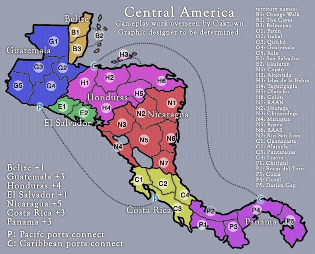
- Click image to enlarge.
• Alright, no mountains.
• All territories have future names... redrew some to conform to reality. Tried to use the shortest names possible - figured Chichicastenango might not fit.
• Blob?
The sooner we get the gameplay basics settled the sooner you lot can start working on the graphics... hoping to get something going by turkey day.
Re: Central America: special project. Gameplay?
- Click image to enlarge.
-
el-presidente
- Posts: 158
- Joined: Fri Sep 19, 2008 2:14 pm
Re: Central America: special project. HELP!
I can't realy see anything wrong, It looks like a great map!. If your a mod, who gives you the gameplay stamp and whatnot? Could you just stamp yourself?
Re: Central America: special project. HELP!
We do try and avoid nepotism in these partsel-presidente wrote:I can't realy see anything wrong, It looks like a great map!. If your a mod, who gives you the gameplay stamp and whatnot? Could you just stamp yourself?
Before moving to the next stage of development, we just want to make sure that any gameplay concerns have been raised and addressed...
My concern is about the Pacific/Caribbean ports - the 'one-sidedness' of the ports on the New World map still gets me muddled - at the very least Panama should be able to attack both oceans?
PB: 2661 | He's blue... If he were green he would die | No mod would be stupid enough to do that
Re: Central America: special project. HELP!
Are you saying that it would be better for play if Panama can hit both, or that the map would be more clear if Panama could hit both? Because I think it is the latter. What I think is getting you muddled about the current set-up is that we started with letters for ports that could attack each other, then simplified it by just having one attack route on each side... now both systems are on the map, and it's redundant and confusing. If I lose the "P" and "C" entirely, all we're dealing with is the attack routes, which for gameplay purposes is very straightforward.MrBenn wrote:My concern is about the Pacific/Caribbean ports - the 'one-sidedness' of the ports on the New World map still gets me muddled - at the very least Panama should be able to attack both oceans?
I tend to think that it makes play more interesting to give Costa Rica a direct link to the north, since both Costa Rica and Panama may be somebody's start position and this provides some balance to the starts. So while I like the attack routes, the system needs to be clarified...
- Click image to enlarge.

I've done so many updates just to make it look cleaner, I almost might as well just finish this up myself!
Re: Central America: special project. HELP!
If nobody else raises any objections, I will stamp this now:

The future of this map is now in the hands of the mapmaking competition... http://www.conquerclub.com/forum/viewto ... 10&t=70130
The future of this map is now in the hands of the mapmaking competition...
PB: 2661 | He's blue... If he were green he would die | No mod would be stupid enough to do that
-
LED ZEPPELINER
- Posts: 1088
- Joined: Tue Nov 25, 2008 10:09 pm
Re: Central America - gameplay discussion thread
all i can say is maybe change the background, but other for that im speechless
Re: Central America: special project. HELP!
[Locked]MrBenn wrote:The future of this map is now in the hands of the mapmaking competition...
PB: 2661 | He's blue... If he were green he would die | No mod would be stupid enough to do that