Land and Sea [Quenched]
Moderator: Cartographers
Forum rules
Please read the Community Guidelines before posting.
Please read the Community Guidelines before posting.

Re: Land And Sea v5p8 gameplay talk
I do not

Re: Land And Sea v5p8 gameplay talk
I think he's saying that you already have connections between two landmasses that jump water, such as EU1 to AF1 (they do share a border, right?), and OC1 to EU9; in both cases those real-life landmasses don't touch.yeti_c wrote:I like the idea of having just "Water" connections...
There are a couple of just "land" connections that span water - so the opposite works for me too.
You could use canals to do the same thing - have two sea territories that border by jumping land. AT3 could border PA4, 'jumping' over central America.
This is a difficult project to feel entirely settled with, since a lot of the playable issues we're now talking about are going to have to be settled in the final desgn stages... for instance, if we decided that we wanted the Panama Canal, there will be the question of how to represent that in such a way that it is clear. Same with the Med' Sea: eventually there would be ways for the designer to work the sea in by taking some liberties with geography in that area, so I don't think we should limit our hopes for that map too much by space/graphic concerns. I say create the gameplay that you'd most want to see on the map assuming that anything is possible graphically - within reason of course - and leave the minor concerns for the artist to figure out.
That said, when it's ready I can't fully stamp this because much of the gameplay stamp requires looking at legend clarity, color, and readability issues. I say that when you think it's there we'll give it a preliminary gameplay thumbs up, and move on the stage 2.
Re: Land And Sea v5p8 gameplay talk
based on my current map, insets will have plenty of space in the legend. not that difficult or a big deal.oaktown wrote: This is a difficult project to feel entirely settled with, since a lot of the playable issues we're now talking about are going to have to be settled in the final desgn stages... for instance, if we decided that we wanted the Panama Canal, there will be the question of how to represent that in such a way that it is clear. Same with the Med' Sea: eventually there would be ways for the designer to work the sea in by taking some liberties with geography in that area, so I don't think we should limit our hopes for that map too much by space/graphic concerns. I say create the gameplay that you'd most want to see on the map assuming that anything is possible graphically - within reason of course - and leave the minor concerns for the artist to figure out.
.
sorry I have to call horseshit on this one. these are ALL graphical issues. you know they are. c'mon.oaktown wrote:That said, when it's ready I can't fully stamp this because much of the gameplay stamp requires looking at legend clarity, color, and readability issues. I say that when you think it's there we'll give it a preliminary gameplay thumbs up, and move on the stage 2.

Re: Land And Sea v5p8 gameplay talk
I think there is a bit of overlap in both... - Gameplay quite often covers things that can confuse the player...edbeard wrote:sorry I have to call horseshit on this one. these are ALL graphical issues. you know they are. c'mon.oaktown wrote:That said, when it's ready I can't fully stamp this because much of the gameplay stamp requires looking at legend clarity, color, and readability issues. I say that when you think it's there we'll give it a preliminary gameplay thumbs up, and move on the stage 2.
But either way - a preliminary stamp is good enough for what you're after to get the GFX going?
C.

Highest score : 2297
Re: Land And Sea v5p8 gameplay talk
As a color-blind player who already can't tell the green army counts from the red ones without the color indicators, color choice on a map is a gameplay issue to me.edbeard wrote:sorry I have to call horseshit on this one. these are ALL graphical issues. you know they are. c'mon.oaktown wrote:That said, when it's ready I can't fully stamp this because much of the gameplay stamp requires looking at legend clarity, color, and readability issues. I say that when you think it's there we'll give it a preliminary gameplay thumbs up, and move on the stage 2.
Anyway, I didn't say I wouldn't give you the approval you are looking for; like the maps that are waiting for currently unavaliable XML options, this map will have to receive some kind of 'conditional' stamp, as in yes the gameplay looks good but there are other gaemplay concerns that will have to be hammered out at a later date.
And to everybody else reading this, I don't really want to get into the business of making special contigency stamps for every map that goes through the Foundry, because then everybody is going to want special treatment.
Re: Land And Sea v5p8 gameplay talk
this is ridiculous.
you're only having to give a contingency stamp because you're making it like that. there's a big difference between conditional and regular so you're not "[giving] the approval [I'm] looking for"
gameplay has to do with how the map plays. graphics has to do with representing the gameplay in a way for people to understand. never have I had to deal with graphical issues to get a gameplay stamp. fucking retarded.
don't treat me like an asshole and say you're giving me special treatment.
Re: Land And Sea v5p8 gameplay talk
Point taken, though I disagree - I've been discussing graphics issues that ineterfere with playability for the past 11 months that I've been doing this.edbeard wrote:has to do with how the map plays. graphics has to do with representing the gameplay in a way for people to understand. never have I had to deal with graphical issues to get a gameplay stamp. fucking retarded.
Anyway, I think I have a reasonable solution which will be revealed in the next 24 hours or so.
Re: Land And Sea v5p8 gameplay talk
- Click image to enlarge.
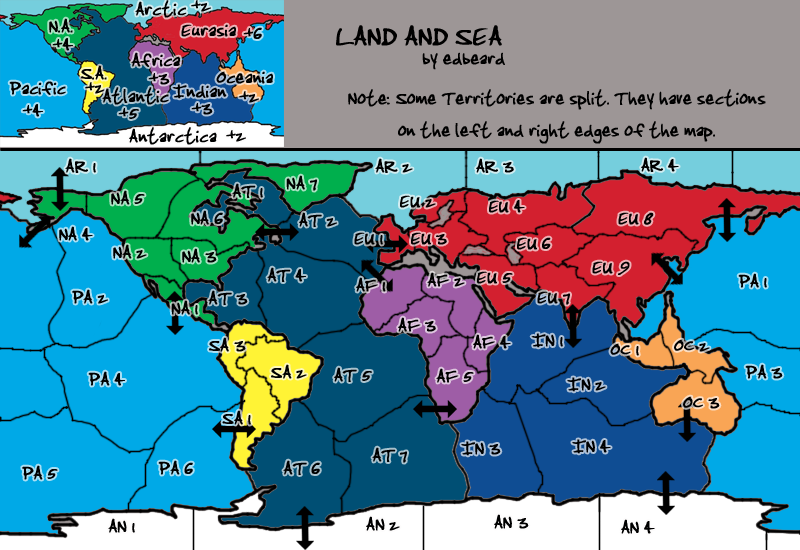
It's probably a good idea to have the canals in terms of opening up the map a bit. here's my proposed gameplay changes...
1. PA4 - AT3 (Panama Canal. perhaps represented in an inset on the legend).
2. Atlantic bonus upped to 6
3. Adding Mediterranean Sea Territory which starts as a neutral 3 and is not part of any continent. Definitely represented in an inset. Connects to AT2 and IN1.
I don't think we need any more land-sea connections (including one to the Arctic sea) so the Med will purely serve as a different path from the Indian Ocean to the North Atlantic.


Re: Land And Sea v5p8 gameplay talk
nah. those huge type bonuses are rarely utilized and basically meaningless.
Re: Land And Sea v6p9 gameplay talk
- Click image to enlarge.
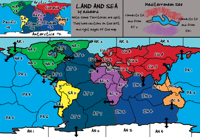
Changes:
1. Panama Canal connection added
2. Mediterranean Sea added. Will start with 3 neutrals and connect to AT2 and IN1 only.
3. Atlantic Bonus increased to 6.
As always, the graphics are only a proposal for whoever ends up doing them. Gameplay is what we're talking about. Specifically...
1. Bonuses
2. Land/Sea connections
3. Where else (if anywhere else) should the Mediterranean Sea connect? I personally say nowhere.
I personally think the connections (Land/Sea, Land/Land, Sea/Sea), bonuses, and balance are good but I, you know, made the map.
Re: Land And Sea v6p9 gameplay talk
Interesting add... an added challenge for the mapmaker. I like it.edbeard wrote:1. Panama Canal connection added
I think it would even be alright as a normal start. Neutral start is good because it's not part of a bonus, but bad because it may discourage the use of that space. Discuss.edbeard wrote:2. Mediterranean Sea added. Will start with 3 neutrals and connect to AT2 and IN1 only.
As it has the most bordering enemies of any region, this seems appropriate.edbeard wrote:3. Atlantic Bonus increased to 6.
Seem alright... overall perhaps a bit higher than classic, but who cares so long as they are consistent cross the map?edbeard wrote:1. Bonuses
Here's a notion that you might hate... you know how it bugged me that the US east coast territory can't access the sea? What if instead of putting an attack route there that added a border to N. Am, you just redrew the NA6 - NA3 border to go north/south, rather than east/west? You'd have an eastern seaboard territory and a great plains territory, and to avoid bottlenecking the eastern seaboard territory could run as far as making an NA2 connection. That way if you wanted to attach the eastern seaboard to Altantic 3, it would create additional connectivity without creating additional defensive borders for anybody?edbeard wrote:2. Land/Sea connections
On the subject of tweaking borders, the Altantic seems very linear. Both AT1 and AT3 only touch one other territory in the same region, and to get from one to the other there is no deviation. What if AT3 was extended north to touch AT2? It would make AT4 less of a blackade territory, which it will still be with that single border south.
If you are going to add a Med Sea connection, I would say make it with a territory that is already on a border; EU5 or Eu1. I think your regions have manageable borders as is. I've been noticed of late that many of our maps have really hard to hold regions, and sometimes you want some easy holds to push the game out of that slow initial phase. If everybody is just whacking each other and nobody can get a foothold anywhere, the outcome of the game is all about cards and lucky dice.edbeard wrote:3. Where else (if anywhere else) should the Mediterranean Sea connect? I personally say nowhere.
Sorry to ask a question that I know has probably been discussed at length, but what is the eventual plan for territory names?

Re: Land And Sea v6p10 gameplay talk
the top lip is red and the bottom is purple, yeti. one set of lips. I could've/possible should've said "on her top lip and bottom lip"
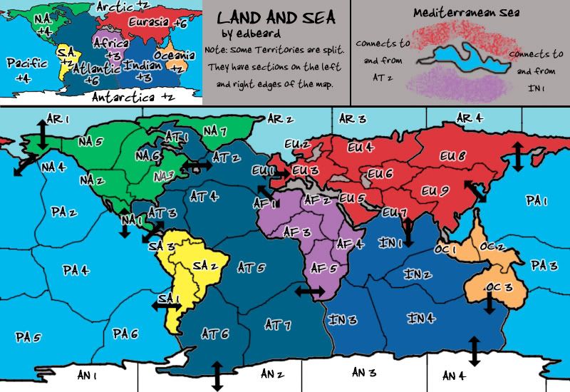
Neutral start is because I don't want people starting with a non-continent territory. I don't think any more land-sea connections are needed in that area. you can fairly easily go from land to sea around there. plus like you said we don't want these places to be too hard to hold. Africa, for example, is helped by being able to take over EU5 and cut down one border and I don't want to take that away. I don't particularly feel like making Eurasia any more harder to hold so adding a border to EU5 seems excessive too. bordering EU1 or AF1 would be excessive in terms of borders 'round there and new borders are out of the question. Seems like I answered my own question. The Mediterranean will stay as a transport between IN1 and AT2.
I agree about the Atlantic borders being redrawn in that area. Not so sure about the North American idea. Kinda weird to have western US but then do it differently in the East. If you can draw up something with all those borders switched around but making sense then I'll give it more consideration. I'm just not sure how to do it. Keeping central america and alaska is key. The rest can be changed I suppose but I'm not sure how and I don't think this "Eastern Port" thing is a big deal so I'll leave that up to someone else to convince me with the full solution. If it can be done, I'm fine with it. If not, I'm fine with that too. Like I said, I'm not particularly motivated to make a change (I don't see it as an improvement just a side-to-side change) so we'll see if anyone else draws up something nice. And, I do mean draw up.
As for names...that's somewhat up to the creativity of the graphicitician but at the moment this is my plan. spacing will be a big issue in many places and these names fit. In the XML, we can have it say "NA4 (Alaska)" or "EU 7 (India)". we do have a lot of A starting names which is somewhat unfortunate but not much can be done about that.
Re: Land And Sea v6p10 gameplay talk
here's what I was thinking for both Atlantic and N. America... I like the Atlantic change, and I can go either way on the US/Canada thing. This would give you a Western US territory, a Great Plains territory, and an Eastern Seaboard territory.edbeard wrote:I agree about the Atlantic borders being redrawn in that area. Not so sure about the North American idea. Kinda weird to have western US but then do it differently in the East. If you can draw up something with all those borders switched around but making sense then I'll give it more consideration. I'm just not sure how to do it.
- Click image to enlarge.
-
gimil

- Posts: 8599
- Joined: Sat Mar 03, 2007 12:42 pm
- Gender: Male
- Location: United Kingdom (Scotland)
Re: Land And Sea v6p10 gameplay talk
It may be worth noting edbeard that is you stick with numbers you should try and mix it up so that two bordering terrs don't share the same or close numbers.
For example AR2 and AT2 could cause accidents with deployment or AT3 may cause accidnets because of people ttacking AT4 or PA4 when they ment to attack the other.
It may sound stupid but with numbers this does easily happen!
For example AR2 and AT2 could cause accidents with deployment or AT3 may cause accidnets because of people ttacking AT4 or PA4 when they ment to attack the other.
It may sound stupid but with numbers this does easily happen!
What do you know about map making, bitch?
Top Score:2403natty_dread wrote:I was wrong
Re: Land And Sea v6p10 gameplay talk
Gimil knows that of which he speaks... see Feudal.gimil wrote:It may be worth noting edbeard that is you stick with numbers you should try and mix it up so that two bordering terrs don't share the same or close numbers... It may sound stupid but with numbers this does easily happen!
But my sense is that the map will pick up real names. It'll take some creativity to make full names fit in the small map, but I think it'll work as long as we are conservative with the names. Western United States might be a mouthful, but West. U.S. would be fine on the map.
Gameplay stuff: settle on how you want the borders and bonuses (which seem alright to me) and whether or not you want to add another arctic connection as discussed earlier, and I don't see why this can't be gameplay stamped. Any other playability issues that come up during the graphics stage can be addressed later.
Re: Land And Sea v6p10 gameplay talk
totally agree on the Atlantic border change.
the NA change not so much. Why are we having Western US but then a Eastern Seaboard territory? Seems kinda weird.
I don't agree on the ability to fit the names but whoever does the graphics can figure that out. I do agree on switching out names to not border each other though.
another arctic connection doesn't seem to add anything to the map. it'd make both Arctic and Eurasia that much harder to hold. rather not do that.
Re: Land And Sea v7p10
- Click image to enlarge.
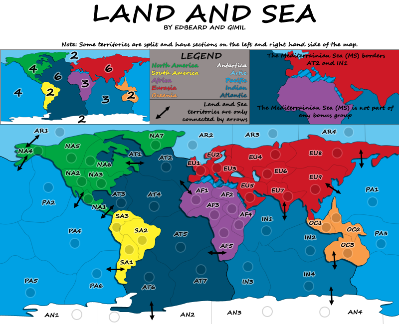
To Do / Thought Points.
1. AT2-AT3 border redrawn so these territories connect. AT2-EU1 needs to be put back
2. put the eastern portion of Eurasia back onto the map (located at the top left of the map)
3. different placement of a few names so something like AT1 and AR1 don't border
4. figure out a different background for the middle legend. the grey looks bad
5. darken/thicken stroke on the continent names in the legend.
6. put something on the top / title area. I said perhaps a ship on the water on one side and the coastline on one side but perhaps the coast should be covered by the title and a wagon could go on the "land" side.
gimil hasn't put his opinion up on this though.
-
gimil
- Posts: 8599
- Joined: Sat Mar 03, 2007 12:42 pm
- Gender: Male
- Location: United Kingdom (Scotland)
Re: Land And Sea v7p10
A better way to word the arrows explaination is also probably worth considering.
IM generally not happy with the way the continent names are presented in legend (Including that damn grey background).
I kind of link the transaprent title just now and I would rather not add an image as this may take away from the simple and vibrant look I would like to keep.
IM generally not happy with the way the continent names are presented in legend (Including that damn grey background).
I kind of link the transaprent title just now and I would rather not add an image as this may take away from the simple and vibrant look I would like to keep.
What do you know about map making, bitch?
Top Score:2403natty_dread wrote:I was wrong
Re: Land And Sea v7p10
but what's the point of this giant title area if we put nothing there?
we could just fit it elsewhere on the map if we're leaving it blank
edit: not really trying to discuss this but putting the opinion there to get feedback on both our POV.
we could just fit it elsewhere on the map if we're leaving it blank
edit: not really trying to discuss this but putting the opinion there to get feedback on both our POV.
-
WidowMakers
- Posts: 2774
- Joined: Mon Nov 20, 2006 9:25 am
- Gender: Male
- Location: Detroit, MI

-
gimil
- Posts: 8599
- Joined: Sat Mar 03, 2007 12:42 pm
- Gender: Male
- Location: United Kingdom (Scotland)
Re: Land And Sea v7p10
I didn't say leave it blank, just something simple to fit the theme.edbeard wrote:but what's the point of this giant title area if we put nothing there?
we could just fit it elsewhere on the map if we're leaving it blank
edit: not really trying to discuss this but putting the opinion there to get feedback on both our POV.
What do you know about map making, bitch?
Top Score:2403natty_dread wrote:I was wrong
Re: Land And Sea v7p10
mountains - beach - ocean
good?
edit: and I'm thinking overhead view as well. it can be kinda cartoony with lines for waves in the water or whatever. But I think this idea is kinda cool. It doesn't have to be all mountains on the left side but maybe a couple and just "plains". The beach and the crashing white waves against it is important though for the middle.
just an idea.
Last edited by edbeard on Sat Nov 29, 2008 7:58 pm, edited 2 times in total.
Re: Land And Sea v7p10
IN1-PA1 maybeWidowMakers wrote:IN1 should border PA1
IN2 should border PA3
IN2-PA3 would force me to make Indian Ocean have a +4 or something. I'd like to keep it with 3 borders.
I think OC1-OC3 should border though. And, maybe the same for NA1-NA3. would mean some border redrawings. not too hard though.