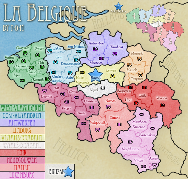
Number of Territories:To Be Counted. Number of Continents:10 Game Play: Classic, no gimmicks, however a +1 auto deploy for holding Brussel, which also starts neutral 2.
I've always admired Belgium, especially Brussels, so I would like to make a map of this beautiful country.
This, the first version, is a bit of a mess. The territory names are long in some places, and very awkward and awkwardly placed; particularly in the northern Green/Blue continents. The font for the territory names will also be changed for readability reasons, although the title will remain the same font unless there is reason. The 88's on the map itself aren't placed well, so comments about "The ____ army coordinates should be ___ rather than ___" aren't needed.
My general aim for this map is to do the country as much justice as I can. One unique factor I'm hoping to create, with help, is this:
I would like to get the Top half of the map's territory names in the Flemmish (It's close to the Dutch language), and the bottom half in French, as that's generally what they speak.
Thank you to Prankcall who came up with the idea when I was wondering what language to put the map in. The map title is in French because Brussels is mainly French speaking. Although there is a fairly small German speaking region of Belgium in the south-east, I don't intend to make them German territory names; although this is open to discussion.
This map is drawn from gnome's previous attempt at this map, which sadly ended in vacationing. So, even though you're no longer with us Gnome, thank you for that which helped inspire me for this map.
So, anyway, here is the messy Version One.
Small.630 by 600.
Small. changed font630 by 600.
I might, might, put one or maybe two low opacity images of Belgium in the key, but I'll see how it looks.
All comments welcome.
Thanks,
Tom.
Last edited by cena-rules on Sat Dec 20, 2008 7:34 am, edited 1 time in total.
An issue I see is about what borders Brussel.
That could probably be made clearer.
Could it be drawn as a regular territory and put the star inside the territory?
Another thing is the size of the territory names. Many of the borders get lost behind them, making attacks difficult to understand. Especially in the Green and Light blue continents. I can see all the borders, I just think it would be easier to understand if the names were smaller.
Its nice to see tom is still making maps, even though he is banned from the forums......
The final word is, banned members are that, banned. That means that even if he wants to continue to contribute to the site, he can't since his ban means he is banished from the forum. Long story short, t-o-m can't continue his map, sorry.