WWI Ottoman Empire [Quenched]
Moderator: Cartographers
Forum rules
Please read the Community Guidelines before posting.
Please read the Community Guidelines before posting.
-
captainwalrus
- Posts: 1018
- Joined: Sun Nov 11, 2007 3:19 pm
- Location: Finnmark
Re: WWI: OTTOMAN EMPIRE [I,Gp,Gr,XML] - V15(p20)
Are army circles realy neccesary? It seems that the center of the territories are light enough.
~ CaptainWalrus

Re: WWI: OTTOMAN EMPIRE [I,Gp,Gr,XML] - V15(p20)
Wellno, they aren't necessary but could be an issue on Beirut and Cyprus, don't yo-u think.captainwalrus wrote:Are army circles realy neccesary? It seems that the center of the territories are light enough.

* Pearl Harbour * Waterloo * Forbidden City * Jamaica * Pot Mosbi
-
WidowMakers
- Posts: 2774
- Joined: Mon Nov 20, 2006 9:25 am
- Gender: Male
- Location: Detroit, MI
Re: WWI: OTTOMAN EMPIRE [I,Gp,Gr,XML] - V15(p20)
The new crowns look good cairns. They fit the color palette well. They blend in but are easily noticed as well. God job.cairnswk wrote:Wellno, they aren't necessary but could be an issue on Beirut and Cyprus, don't yo-u think.captainwalrus wrote:Are army circles realy neccesary? It seems that the center of the territories are light enough.
As far as army circles go I think it is ok. You could move the crown on Cyprus a bit tot eh left and move the 88 left as well. Plus you could make the island a bit bigger (I don't think this map is going for actual sized accurate geography.
You could also do the same for Beirut. Make the sea border move left and widen the country a bit. Maybe?
WM

Re: WWI: OTTOMAN EMPIRE [I,Gp,Gr,XML] - V15(p20)
Done.WidowMakers wrote:The new crowns look good cairns. They fit the color palette well. They blend in but are easily noticed as well. God job.cairnswk wrote:Wellno, they aren't necessary but could be an issue on Beirut and Cyprus, don't yo-u think.captainwalrus wrote:Are army circles realy neccesary? It seems that the center of the territories are light enough.
As far as army circles go I think it is ok. You could move the crown on Cyprus a bit tot eh left and move the 88 left as well. Plus you could make the island a bit bigger (I don't think this map is going for actual sized accurate geography.
You could also do the same for Beirut. Make the sea border move left and widen the country a bit. Maybe?
WM
- Click image to enlarge.
- Click image to enlarge.
http://i155.photobucket.com/albums/s282 ... n_V17L.jpg
http://h1.ripway.com/cairnswk/_WWI_Ottoman_Empire.xml
* Pearl Harbour * Waterloo * Forbidden City * Jamaica * Pot Mosbi
Re: WWI: OTTOMAN EMPIRE [I,Gp,Gr,XML] - V16(p21)
is it just me, or are the crowns way more bad-ass now? 
Re: WWI: OTTOMAN EMPIRE [I,Gp,Gr,XML] - V16(p21)
Jut a touch of royalty there with a purple disc behind them...only thing i was happy with.oaktown wrote:is it just me, or are the crowns way more bad-ass now?
* Pearl Harbour * Waterloo * Forbidden City * Jamaica * Pot Mosbi

Re: WWI: OTTOMAN EMPIRE [I,Gp,Gr,XML] - V16(p21)
I like the new crowns.cairnswk wrote:Jut a touch of royalty there with a purple disc behind them...only thing i was happy with.oaktown wrote:is it just me, or are the crowns way more bad-ass now?
Quench?
-
The Neon Peon
- Posts: 2342
- Joined: Sat Jun 14, 2008 12:49 pm
- Gender: Male
Re: WWI: OTTOMAN EMPIRE [I,Gp,Gr,XML] - V16(p21)
Crowns look a lot better now.
Would you mind enlarging your signature? It is very hard to read at the moment.
Would you mind enlarging your signature? It is very hard to read at the moment.
Re: WWI: OTTOMAN EMPIRE [I,Gp,Gr,XML] - V16(p21)
Nah...i think it's OK as is..if you don't know that butterfly by now you never will.The Neon Peon wrote:Crowns look a lot better now.
Would you mind enlarging your signature? It is very hard to read at the moment.
EDIT: on 2nd thoughts, i redid the butterfly completely. Please refresh.
* Pearl Harbour * Waterloo * Forbidden City * Jamaica * Pot Mosbi
Re: WWI: OTTOMAN EMPIRE [I,Gp,Gr,XML] - V16(p21)
That new butterfly is seriously badass 
Re: WWI: OTTOMAN EMPIRE [I,Gp,Gr,XML] - V16(p21)
and the colours fit the map and theme so well too....good work.ZeakCytho wrote:That new butterfly is seriously badass
* Pearl Harbour * Waterloo * Forbidden City * Jamaica * Pot Mosbi
Re: WWI: OTTOMAN EMPIRE [I,Gp,Gr,XML] - V16(p21)
Sorry if this has already been mentioned, but the colours of the italian colony and the hussain of mecca are too similar and since they are close to each other on the map, maybe a change is in order. Also the top left side of the arch (just right of the title) looks empty, maybe put your signature there? (or on the right, moving whatever that logo thats on the right currently to the left.
Re: WWI: OTTOMAN EMPIRE [I,Gp,Gr,XML] - V17
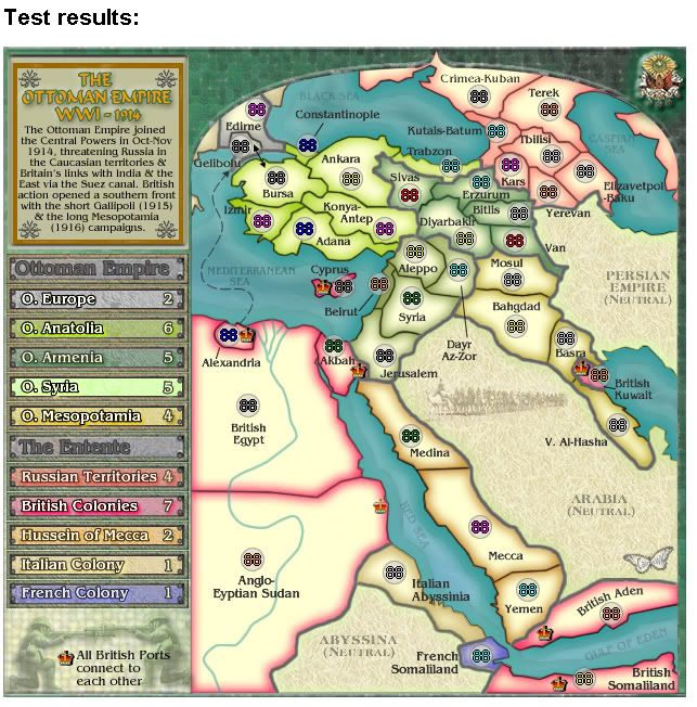
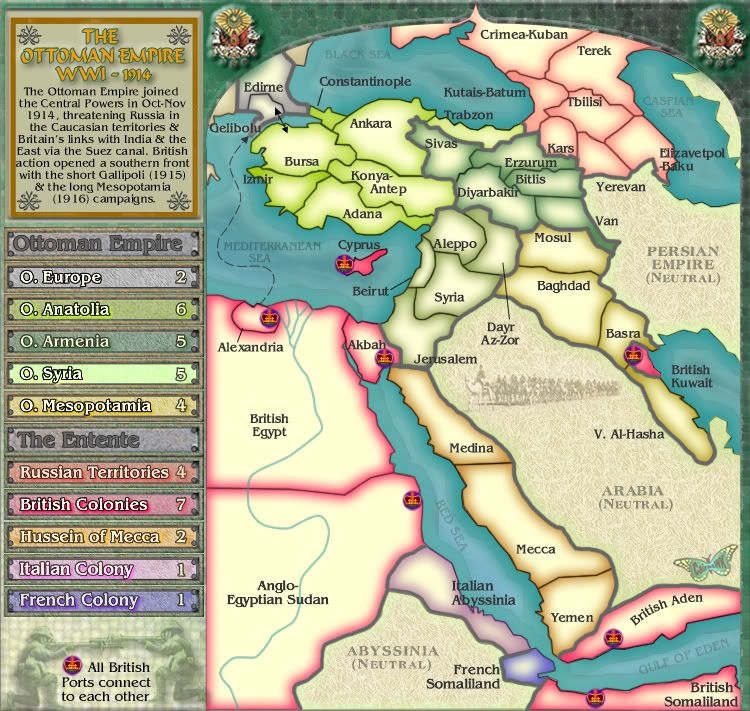
Done. Please refresh your screen.
http://i155.photobucket.com/albums/s282 ... n_V17S.jpg
http://i155.photobucket.com/albums/s282 ... n_V17L.jpg
http://h1.ripway.com/cairnswk/_WWI_Ottoman_Empire.xml[/quote]
- Click image to enlarge.
http://i155.photobucket.com/albums/s282 ... n_V17L.jpg
http://h1.ripway.com/cairnswk/_WWI_Ottoman_Empire.xml[/quote]
* Pearl Harbour * Waterloo * Forbidden City * Jamaica * Pot Mosbi
-
The Neon Peon
- Posts: 2342
- Joined: Sat Jun 14, 2008 12:49 pm
- Gender: Male
Re: WWI: OTTOMAN EMPIRE [I,Gp,Gr,XML] - V16(p21)
Italian Abyssina has the purple line that is at the edge of the territory near the red sea moved in slightly into the territory away from it's edge. Mostly visible on the large map, and only in a few places on the small one.
Re: WWI: OTTOMAN EMPIRE [I,Gp,Gr,XML] - V16(p21)
OK, i see that...are there any others you can see before i go posting an update.The Neon Peon wrote:Italian Abyssina has the purple line that is at the edge of the territory near the red sea moved in slightly into the territory away from it's edge. Mostly visible on the large map, and only in a few places on the small one.
* Pearl Harbour * Waterloo * Forbidden City * Jamaica * Pot Mosbi
-
the.killing.44

- Posts: 4724
- Joined: Thu Oct 23, 2008 7:43 pm
- Gender: Male
- Location: now tell me what got two gums and knows how to spit rhymes
- Contact:
Re: WWI: OTTOMAN EMPIRE [I,Gp,Gr,XML] - V16(p21)
[nitpick]
It's not the same thing, but Trabzon's coastal border seems to be somewhat erased, or just skinnier than the others.
It wouldn't hurt to have the middle one of the Nile's delta (the one shaped like a Y within the bigger Y) connect to the overall Y better.
I'd like to see you add the line from Beirut to the tert on the large map. Without it it's, well,
[/nitpick]
This is looking great, cairns!
.44
Re: WWI: OTTOMAN EMPIRE [I,Gp,Gr,XML] - V17
Done.cairnswk wrote:OK, i see that...are there any others you can see before i go posting an update.The Neon Peon wrote:Italian Abyssina has the purple line that is at the edge of the territory near the red sea moved in slightly into the territory away from it's edge. Mostly visible on the large map, and only in a few places on the small one.
Done. Please refresh your browserthe.killing.44 wrote:[nitpick]
It's not the same thing, but Trabzon's coastal border seems to be somewhat erased, or just skinnier than the others.
It wouldn't hurt to have the middle one of the Nile's delta (the one shaped like a Y within the bigger Y) connect to the overall Y better.
I'd like to see you add the line from Beirut to the tert on the large map. Without it it's, well,
[/nitpick]
This is looking great, cairns!
.44
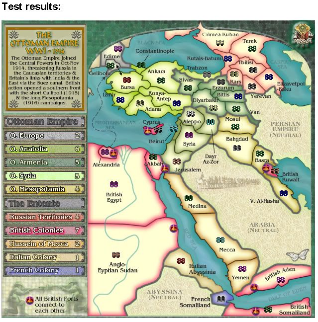
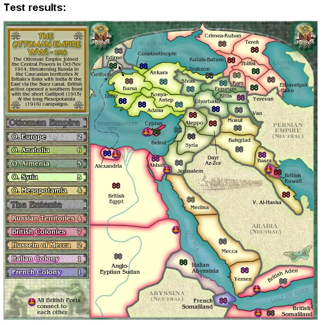
Version 17.
- Click image to enlarge.
http://i155.photobucket.com/albums/s282 ... n_V17S.jpg
http://i155.photobucket.com/albums/s282 ... n_V17L.jpg
http://h1.ripway.com/cairnswk/_WWI_Ottoman_Empire.xml
* Pearl Harbour * Waterloo * Forbidden City * Jamaica * Pot Mosbi
-
The Neon Peon
- Posts: 2342
- Joined: Sat Jun 14, 2008 12:49 pm
- Gender: Male
Re: WWI: OTTOMAN EMPIRE [I,Gp,Gr,XML] - V16(p21)
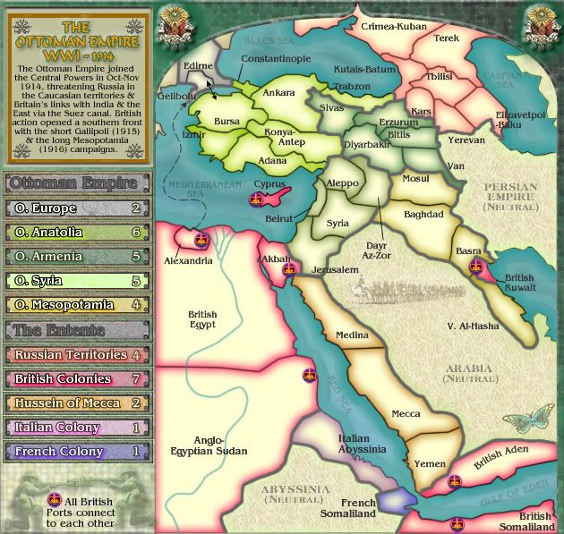
Woah... why is Europe worth 2? It is only 2 territories.
Secondly, Constantinople name needs to be moved closer to the territory, and the line connecting the name to the territory is missing on the large map.
Thirdly, Trabzon appears to be a different color from the rest of the continent, was this intentional?
Fourthly, there is a little tip of a black line showing in Adana (where the shoreline changes direction, the line to distinguish between the sea and land continues for a few pixels.
Fifthly, Kutais-Batum to Erzurum border has a little dark splotch.
Re: WWI: OTTOMAN EMPIRE [I,Gp,Gr,XML] - V16(p21)
Got any more before i start making changes?The Neon Peon wrote:Woah... why is Europe worth 2? It is only 2 territories.
Secondly, Constantinople name needs to be moved closer to the territory, and the line connecting the name to the territory is missing on the large map.
Thirdly, Trabzon appears to be a different color from the rest of the continent, was this intentional?
Fourthly, there is a little tip of a black line showing in Adana (where the shoreline changes direction, the line to distinguish between the sea and land continues for a few pixels.
Fifthly, Kutais-Batum to Erzurum border has a little dark splotch.
* Pearl Harbour * Waterloo * Forbidden City * Jamaica * Pot Mosbi
-
The Neon Peon
- Posts: 2342
- Joined: Sat Jun 14, 2008 12:49 pm
- Gender: Male
Re: WWI: OTTOMAN EMPIRE [I,Gp,Gr,XML] - V16(p21)
Crimea and Terek. Those two definitely look different in terms of the text.
Beiruit has no dark green near the borders, not sure if they is for visibility, or a mistake.
The line that connects Alexandria to the territory extends a different amount on the small and large maps.
Yerevan name could be moved down a pixel or two.
Don't see anything else.
Beiruit has no dark green near the borders, not sure if they is for visibility, or a mistake.
The line that connects Alexandria to the territory extends a different amount on the small and large maps.
Yerevan name could be moved down a pixel or two.
Don't see anything else.
-
sailorseal
- Posts: 2735
- Joined: Sun May 25, 2008 1:49 pm
- Gender: Male
- Location: conquerclub.com
Re: WWI: OTTOMAN EMPIRE [I,Gp,Gr,XML] - V16(p21)
I love the idea, I am a HUGE WWII fan and this map is great. It is also good looking and historically accurate.
Re: WWI: OTTOMAN EMPIRE [I,Gp,Gr,XML] - V16(p21)
sailor...i don't mean to be rude...but i wouldn't want you in my army if you can't read....this is WW (1) One 1914 not WWII (two)...or did you just get it wrong.sailorseal wrote:I love the idea, I am a HUGE WWII fan and this map is great. It is also good looking and historically accurate.
Glad you like it though.
* Pearl Harbour * Waterloo * Forbidden City * Jamaica * Pot Mosbi
Re: WWI: OTTOMAN EMPIRE [I,Gp,Gr,XML] - V16(p21)
Coz' it's got 3 borders and one of them is a one way from a large power....nobody seemed to mind that bonus.The Neon Peon wrote:Woah... why is Europe worth 2? It is only 2 territories.
Hussein of Mecca is 3 terts with two borders and it's got 2 also.
Done.Secondly, Constantinople name needs to be moved closer to the territory, and the line connecting the name to the territory is missing on the large map.
no. it's the same colour, just doesn't have the middle creamish glow.Thirdly, Trabzon appears to be a different color from the rest of the continent, was this intentional?
Fixed.Fourthly, there is a little tip of a black line showing in Adana (where the shoreline changes direction, the line to distinguish between the sea and land continues for a few pixels.
FixedFifthly, Kutais-Batum to Erzurum border has a little dark splotch.
Crimea needed bolding. Fixed.The Neon Peon wrote:Crimea and Terek. Those two definitely look different in terms of the text.
Fixed....length of inner glowBeiruit has no dark green near the borders, not sure if they is for visibility, or a mistake.
Fixed.The line that connects Alexandria to the territory extends a different amount on the small and large maps.
Fixed.Yerevan name could be moved down a pixel or two.
Good. ThanksDon't see anything else.
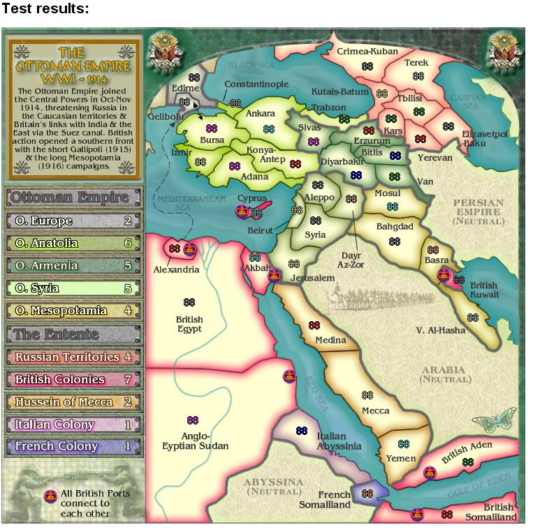
Please refresh your browser...
- Click image to enlarge.
- Click image to enlarge.
http://i155.photobucket.com/albums/s282 ... n_V17L.jpg
http://h1.ripway.com/cairnswk/_WWI_Ottoman_Empire.xml
* Pearl Harbour * Waterloo * Forbidden City * Jamaica * Pot Mosbi
Re: WWI: OTTOMAN EMPIRE [I,Gp,Gr,XML] - V16(p21)
neither do I.The Neon Peon wrote:Don't see anything else.
-
sailorseal
- Posts: 2735
- Joined: Sun May 25, 2008 1:49 pm
- Gender: Male
- Location: conquerclub.com
Re: WWI: OTTOMAN EMPIRE [I,Gp,Gr,XML] - V16(p21)
Sorry late nightscairnswk wrote:sailor...i don't mean to be rude...but i wouldn't want you in my army if you can't read....this is WW (1) One 1914 not WWII (two)...or did you just get it wrong.sailorseal wrote:I love the idea, I am a HUGE WWII fan and this map is great. It is also good looking and historically accurate.
Glad you like it though.