Central America [Quenched]
Moderator: Cartographers
Forum rules
Please read the Community Guidelines before posting.
Please read the Community Guidelines before posting.
-
Incandenza

- Posts: 4949
- Joined: Thu Oct 19, 2006 5:34 pm
- Gender: Male
- Location: Playing Eschaton with a bucket of old tennis balls
Re: Central America [D] V3 up!!
Before we start going nuts with the long-range attack routes, could we perhaps discuss noting said routes with some sort of icon rather than long dotted lines?
THOTA: dingdingdingdingdingdingBOOM
Te Occidere Possunt Sed Te Edere Non Possunt Nefas Est
Te Occidere Possunt Sed Te Edere Non Possunt Nefas Est
-
lgoasklucyl

- Posts: 526
- Joined: Mon Apr 07, 2008 8:49 pm
- Gender: Male
- Location: Somewhere in the 20th century.
Re: Central America [D] V3 up!!
I liked the dotted lines better, personally. I could try icons out in the next version and poll to see what everyone thinks.Incandenza wrote:Before we start going nuts with the long-range attack routes, could we perhaps discuss noting said routes with some sort of icon rather than long dotted lines?

-
sailorseal

- Posts: 2735
- Joined: Sun May 25, 2008 1:49 pm
- Gender: Male
- Location: conquerclub.com
Re: Central America [D] V3 up!!
I think the Nicaragua bonus is to small. It can be assaulted from many territories and has a large border. Also in a 1v1 game one player might be able to start out with a pretty good bonus. I have no ideas on how to change that but you should keep that in mind. I like this map a lot! Keep at it!
-
the.killing.44

- Posts: 4724
- Joined: Thu Oct 23, 2008 7:43 pm
- Gender: Male
- Location: now tell me what got two gums and knows how to spit rhymes
- Contact:
Re: Central America [D] V3 up!!
No gameplay discussion … it's already been handled. The comp was for the graphics, no?sailorseal wrote:I think the Nicaragua bonus is to small. It can be assaulted from many territories and has a large border. Also in a 1v1 game one player might be able to start out with a pretty good bonus. I have no ideas on how to change that but you should keep that in mind. I like this map a lot! Keep at it!
Anyway, great job on the comp! I love the new compass and the text looks great. My only quarrel is the dotted lines — like someone said before they are too bumpy. Oh, and I think making the title a bit brighter would suit the map better, as well as making the yellow on the gradient of the sigs not as bright.
I'd start work on the small v — naming might be a bit difficult.
.44
-
lgoasklucyl
- Posts: 526
- Joined: Mon Apr 07, 2008 8:49 pm
- Gender: Male
- Location: Somewhere in the 20th century.
Re: Central America [D] V3 up!!
Indeed on both counts. Gameplay was debated and sorted prior to the contest even starting and the small version is going to be a pain in the ass with terit names.the.killing.44 wrote:No gameplay discussion … it's already been handled. The comp was for the graphics, no?sailorseal wrote:I think the Nicaragua bonus is to small. It can be assaulted from many territories and has a large border. Also in a 1v1 game one player might be able to start out with a pretty good bonus. I have no ideas on how to change that but you should keep that in mind. I like this map a lot! Keep at it!
Anyway, great job on the comp! I love the new compass and the text looks great. My only quarrel is the dotted lines — like someone said before they are too bumpy. Oh, and I think making the title a bit brighter would suit the map better, as well as making the yellow on the gradient of the sigs not as bright.
I'd start work on the small v — naming might be a bit difficult.
.44
Regarding the lines: next version will have icons and a poll
-
sailorseal
- Posts: 2735
- Joined: Sun May 25, 2008 1:49 pm
- Gender: Male
- Location: conquerclub.com
Re: Central America [D] V3 up!!
The colors don't float my boat. Neither does the texture. I would like to see those changed along with the assault lines.
-
lgoasklucyl
- Posts: 526
- Joined: Mon Apr 07, 2008 8:49 pm
- Gender: Male
- Location: Somewhere in the 20th century.
Re: Central America [D] V3 up!!
I haven't had color complaints yet, as most people have stated they like them the way they are. If a huge consensus had a problem I would change them but it's an insane amount of work when most people like themsailorseal wrote:The colors don't float my boat. Neither does the texture. I would like to see those changed along with the assault lines.
The texture I've actually contemplated changing, and will be looking into it before the next draft.

Re: Central America [D] V3 up!!
Central America: I like it! I was thinking that CA would be an interesting map. Banana Republics!
Also, not sure where to post such a suggestion, but ....
How about a Mexico Map ... or, a Mayan Civilization map .... with that 2012 end of the world thing getting nearer, I'd bet it would be (at least mildly) popular. The Mayans covered a nice chunk of territory in the western hemi.
Sorry if this is out of place. (feel free to move or delete) I'm still opening doors in this place that I've no idea where it will lead. And I LOVE this game. So much better Online.
Thx.
Re: Central America [D] V3 up!!
ODWO wrote:Central America: I like it! I was thinking that CA would be an interesting map. Banana Republics!
Also, not sure where to post such a suggestion, but ....
How about a Mexico Map ... or, a Mayan Civilization map .... with that 2012 end of the world thing getting nearer, I'd bet it would be (at least mildly) popular. The Mayans covered a nice chunk of territory in the western hemi.
Sorry if this is out of place. (feel free to move or delete) I'm still opening doors in this place that I've no idea where it will lead. And I LOVE this game. So much better Online.
Thx.
comments on this map go here, ideas for other maps go in the Map Ideas sub-forum
don't worry, I made the same mistake at my first visit to the foundry
[/offtopic]
1) The name 'Panama' in the minimap is very dark and hard to read because of that
2) I do not care for how the attack routes at a few places go paralel (sp?) to the places that the end/start at. Shouldn't they just get there straight on?
3) The Cayes look like they are floating
4) Its still rough along some places
-
LED ZEPPELINER
- Posts: 1088
- Joined: Tue Nov 25, 2008 10:09 pm
Re: Central America [D] V3 up!!
on the minimap, try getting rid of the territory borders, and just leave the bonus borders
sailorseal wrote:My big boy banana was out the whole time
AndyDufresne wrote:Forever linked at the hip's-banana! (That sounds strange, don't quote me.)AndyDufresne wrote:Many Happy Bananas to everyone, lets party...with Bananas.
--Andy
-
lgoasklucyl
- Posts: 526
- Joined: Mon Apr 07, 2008 8:49 pm
- Gender: Male
- Location: Somewhere in the 20th century.
Re: Central America [D] V3 up!!
Sorry about the delay everyone, I've been sick as hell since last week and haven't had the time to fix up the next version 
I promise it'll be an extra-big update when it comes to make up for it
I promise it'll be an extra-big update when it comes to make up for it

Re: Central America [D] V3 up!!
Keep the flu out of the Foundry... that crap is contagious, and we have work to do.lgoasklucyl wrote:Sorry about the delay everyone, I've been sick as hell since last week and haven't had the time to fix up the next version
Re: Central America [D] V3 up!!
get better soon lgoa!oaktown wrote:Keep the flu out of the Foundry... that crap is contagious, and we have work to do.lgoasklucyl wrote:Sorry about the delay everyone, I've been sick as hell since last week and haven't had the time to fix up the next version
its no fun being sick. Its going through my family right now. I had it last week
Re: Central America [D] V3 up!!
gameplay thought: what if instead of having sea attack routes on both coasts, we interrupted each route with a territory? "Pacific Shipping Lane" and "Caribbean Shipping Lane" - this would break up the instant top to bottom attacks a bit yet still make those port territories borders.
The text of the territory title could wrap along the attack route lines.
The text of the territory title could wrap along the attack route lines.
-
lgoasklucyl
- Posts: 526
- Joined: Mon Apr 07, 2008 8:49 pm
- Gender: Male
- Location: Somewhere in the 20th century.
Re: Central America [D] V3 up!!
Interesting idea. Anyone else have thoughts on it?oaktown wrote:gameplay thought: what if instead of having sea attack routes on both coasts, we interrupted each route with a territory? "Pacific Shipping Lane" and "Caribbean Shipping Lane" - this would break up the instant top to bottom attacks a bit yet still make those port territories borders.
The text of the territory title could wrap along the attack route lines.
I like it personally. The straight-through attack route is kind of an easy movement. Something to stop it would add a bit of challenge.
-
lgoasklucyl
- Posts: 526
- Joined: Mon Apr 07, 2008 8:49 pm
- Gender: Male
- Location: Somewhere in the 20th century.
Re: Central America [D] V3 up!!
Sickness over- production may continue I'm still a little woozy but whatever, life goes on 
#1) The same dotted lines, but re-drawn using my spifftastic new tablet to make them look neater
#2) Perhaps symbols used instead, as quite a full people have expressed distaste for the current line (though I like them personally )
)
#3) Maybe tack those extra territs in. Perhaps I should poll on that now before pushing out a new version

Thanks =)
I could bump it up to be a little bright and/or drop the opacity of the stroke a little.bryguy wrote: 1) The name 'Panama' in the minimap is very dark and hard to read because of that
It's an awkward attack route so I figured moving it with the land would help make it slightly more interesting (goes with the smoothness of the scheme). The attack routes are up for some serious changes coming soon though, as many people aren't happy with them. I'm thinking next version I will have two maps up for polledness (regarding attack routes):bryguy wrote:2) I do not care for how the attack routes at a few places go paralel (sp?) to the places that the end/start at. Shouldn't they just get there straight on?
#1) The same dotted lines, but re-drawn using my spifftastic new tablet to make them look neater
#2) Perhaps symbols used instead, as quite a full people have expressed distaste for the current line (though I like them personally
#3) Maybe tack those extra territs in. Perhaps I should poll on that now before pushing out a new version
I'll find a way to fix this. Unfortunately the drop shadow for the entire image is one layer so perhaps I'll just remove the islands from that layer and do it again.... without making them float above the ocean. I would like to live on a floating island personally...bryguy wrote:3) The Cayes look like they are floating
eg: At the Mexico border? If that's what you're referring to I'm going to buff out the whole image and touch up all these things once the colors are 100% set in stone. Unfortunately my bevel layer isn't applied to the colors, but a 0% fill layer over the colors so it's kind of a pain to touch up after repeated changes- so I'll make it 100% after everything is decided.bryguy wrote:4) Its still rough along some places
Thanks =)
-
Incandenza
- Posts: 4949
- Joined: Thu Oct 19, 2006 5:34 pm
- Gender: Male
- Location: Playing Eschaton with a bucket of old tennis balls
Re: Central America [D] V3 up!!
I like it, tho I feel like the whole attack line and shipping lane concept could be tied better into the canal, being the dominant economic fixture of the region...oaktown wrote:gameplay thought: what if instead of having sea attack routes on both coasts, we interrupted each route with a territory? "Pacific Shipping Lane" and "Caribbean Shipping Lane" - this would break up the instant top to bottom attacks a bit yet still make those port territories borders.
The text of the territory title could wrap along the attack route lines.
THOTA: dingdingdingdingdingdingBOOM
Te Occidere Possunt Sed Te Edere Non Possunt Nefas Est
Te Occidere Possunt Sed Te Edere Non Possunt Nefas Est
Re: Central America [D] V3 up!!
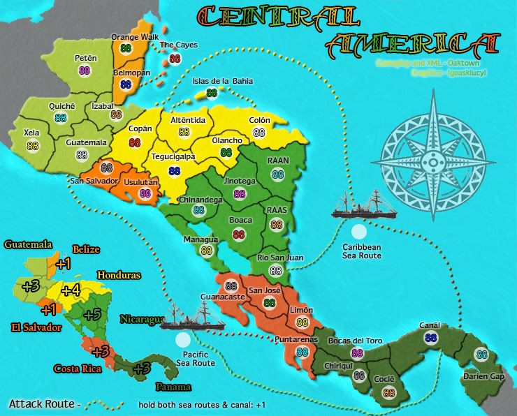
I believe I originally had both of the sea routes coming out of the Canal, but it looked as if Panama was going to get whipped around by players from both sides. The proposed introduction of an intermediary territory between the canal and the norther regions might make it viable to have both sea routes hit the canal - that way you could conceivably pass from the northwest oversea through the canal and up to the northeast.Incandenza wrote:I feel like the whole attack line and shipping lane concept could be tied better into the canal, being the dominant economic fixture of the region...
Another interesting notion would to give a +1 sea power bonus for holding the canal and both sea routes... and the sea routes could connect to multiple ports. Hmm... easier to show you what i mean than to explain...
- Click image to enlarge.
Visualy, I really like the compass rose; however it fails to fit the rest of the map. You've got a bright color palette going , but the compass rose is dull and understated. It shouldn't be the focal point of the map, but it needs some bright highlights and black shadows to fit the rest of the map.

Re: Central America [D] Gameplay Poll Up!!!!!
I like the proposed gameplay tweak - it incorporates the Panama Canal nicely, and makes the map a bit more unique 

PB: 2661 | He's blue... If he were green he would die | No mod would be stupid enough to do that
-
LED ZEPPELINER
- Posts: 1088
- Joined: Tue Nov 25, 2008 10:09 pm
Re: Central America [D] Gameplay Poll Up!!!!!
i think that you should make all of your attackroutes the same size/color
-
lgoasklucyl
- Posts: 526
- Joined: Mon Apr 07, 2008 8:49 pm
- Gender: Male
- Location: Somewhere in the 20th century.
Re: Central America [D] Gameplay Poll Up!!!!!
I like Oaktown's proposed changes.
A lot of the community seems to lose interest in maps based solely on geography and with no (at least remotely) interesting gameplay features. Adding this in would help mix the map up and not turn it into a funnel-fest like Indo or similar maps.
I especially like the +1 for the canal and ports, and the two additional attack-routes to the middle.
Regarding the compass: I can easily add color/resize it to make it more appropriate and fit with the addition of sea routes. Obviously the mini-map will also need to be moved.
-
lgoasklucyl
- Posts: 526
- Joined: Mon Apr 07, 2008 8:49 pm
- Gender: Male
- Location: Somewhere in the 20th century.
Re: Central America [D] V3 up!!
Along what lines did you search for the boats? I'm assuming boats are the better way to go as opposed to making up pretend-geography like I had originally thoughtoaktown wrote:
- Click image to enlarge.
-
Incandenza
- Posts: 4949
- Joined: Thu Oct 19, 2006 5:34 pm
- Gender: Male
- Location: Playing Eschaton with a bucket of old tennis balls
Re: Central America [D] Gameplay Poll Up!!!!! (See P. 3)
Those boats look pretty similar to the steamers in oak's eastern hemisphere map.... you might be better off going with modern supertankers or something along those lines.
Plus thi allows you to make the ports an icon, icons attack matching shipping lane, shipping lane attacks all matching ports, good times.
Plus thi allows you to make the ports an icon, icons attack matching shipping lane, shipping lane attacks all matching ports, good times.
THOTA: dingdingdingdingdingdingBOOM
Te Occidere Possunt Sed Te Edere Non Possunt Nefas Est
Te Occidere Possunt Sed Te Edere Non Possunt Nefas Est

Re: Central America [D] Gameplay Poll Up!!!!! (See P. 3)
the colours of the 2 south regions are too similar i can't make a difference between the 2 please ask a colorblind before putting colours on a map, but that's a nice map you made but those south regions colours are the same to my eyes and i'm sure i'm not the only colorblind person on this site they both look brown to me and the same brown
-
lgoasklucyl
- Posts: 526
- Joined: Mon Apr 07, 2008 8:49 pm
- Gender: Male
- Location: Somewhere in the 20th century.
Re: Central America [D] Gameplay Poll Up!!!!! (See P. 3)
You're certainly not. It has been raised and will be changed. I'm not red-green so I didn't notice it. I have problems with other colors, but typically not between red and green, it shall be fixedben79 wrote:the colours of the 2 south regions are too similar i can't make a difference between the 2 please ask a colorblind before putting colours on a map, but that's a nice map you made but those south regions colours are the same to my eyes and i'm sure i'm not the only colorblind person on this site they both look brown to me and the same brown
Incandenza wrote:Those boats look pretty similar to the steamers in oak's eastern hemisphere map.... you might be better off going with modern supertankers or something along those lines.
Plus thi allows you to make the ports an icon, icons attack matching shipping lane, shipping lane attacks all matching ports, good times.
Are you saying utilizing the same icon for the boat as the ports? Or rather different ports on either side, and the same boats?

I could use the white tanks/walkways and custom make ports.

Example of something I could use for tanker.
Therefore: Three ports on each side; each port can hit tanker, tanker hits all ports.
Huzzah?