Are you supporting the House of Lancaster by any chance?
War of the Roses Map (Version 13 p.9 comments please!)
Moderator: Cartographers
Forum rules
Please read the Community Guidelines before posting.
Please read the Community Guidelines before posting.
-
walnutwatson

- Posts: 64
- Joined: Mon Jul 07, 2008 7:24 am
Re: War of the Roses Map (Version 11 p.6)
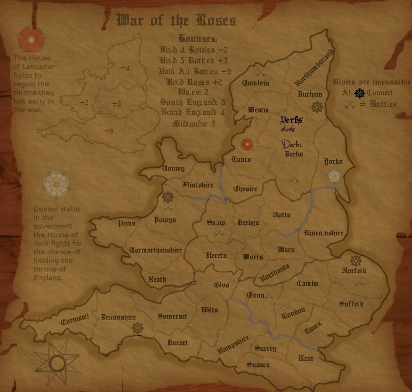
The map is looking great. I'm sure there's some reason with it being this far down the line but what's the reason for half of Yorkshire being swallowed up by Derbyshire. Nothing against Derbyshire, it's a lovely place, but it's only about a third the size of Yorkshire whereas on your map it's about twice as big as Yorkshire.
Are you supporting the House of Lancaster by any chance?
Are you supporting the House of Lancaster by any chance?
Re: War of the Roses Map (Version 11 p.6)
no...in reality yorkshire and lancanshire would be touching...thus making it easier to hold the two houses...so i wanted to split them up a bit...for gameplay purposes.walnutwatson wrote:The map is looking great. I'm sure there's some reason with it being this far down the line but what's the reason for half of Yorkshire being swallowed up by Derbyshire. Nothing against Derbyshire, it's a lovely place, but it's only about a third the size of Yorkshire whereas on your map it's about twice as big as Yorkshire.
Are you supporting the House of Lancaster by any chance?

Re: War of the Roses Map (Version 11 p.6)
I would support geographical accuracy, although I still think that some thought needs to go into the gameplay; the North is a much better place to start than the South - can you think of some ways to address this imbalance?bspride wrote:no...in reality yorkshire and lancanshire would be touching...thus making it easier to hold the two houses...so i wanted to split them up a bit...for gameplay purposes.walnutwatson wrote:The map is looking great. I'm sure there's some reason with it being this far down the line but what's the reason for half of Yorkshire being swallowed up by Derbyshire. Nothing against Derbyshire, it's a lovely place, but it's only about a third the size of Yorkshire whereas on your map it's about twice as big as Yorkshire.
Are you supporting the House of Lancaster by any chance?

PB: 2661 | He's blue... If he were green he would die | No mod would be stupid enough to do that
-
walnutwatson
- Posts: 64
- Joined: Mon Jul 07, 2008 7:24 am
Re: War of the Roses Map (Version 11 p.6)
Makes sense. Can't wait to play it.bspride wrote:no...in reality yorkshire and lancanshire would be touching...thus making it easier to hold the two houses...so i wanted to split them up a bit...for gameplay purposes.walnutwatson wrote:The map is looking great. I'm sure there's some reason with it being this far down the line but what's the reason for half of Yorkshire being swallowed up by Derbyshire. Nothing against Derbyshire, it's a lovely place, but it's only about a third the size of Yorkshire whereas on your map it's about twice as big as Yorkshire.
Are you supporting the House of Lancaster by any chance?

Re: War of the Roses Map (Version 11 p.6)
i like the writing but it think it need to be changed a bit, its a bit hard too read
Re: War of the Roses Map (Version 11 p.6)
yeah...i will address this in the next update...probably will get that done by next sunday...school is jamming me up...drake_259 wrote:i like the writing but it think it need to be changed a bit, its a bit hard too read
Re: War of the Roses Map (Version 11 p.6)
yeah...i want to have the houses start as neutrals...probably a 4 or 5 so its hard to gain in one turn...also the ports will be a good way of quickly navigating to stop ones bonusMrBenn wrote:I would support geographical accuracy, although I still think that some thought needs to go into the gameplay; the North is a much better place to start than the South - can you think of some ways to address this imbalance?bspride wrote:no...in reality yorkshire and lancanshire would be touching...thus making it easier to hold the two houses...so i wanted to split them up a bit...for gameplay purposes.walnutwatson wrote:The map is looking great. I'm sure there's some reason with it being this far down the line but what's the reason for half of Yorkshire being swallowed up by Derbyshire. Nothing against Derbyshire, it's a lovely place, but it's only about a third the size of Yorkshire whereas on your map it's about twice as big as Yorkshire.
Are you supporting the House of Lancaster by any chance?
-
e_i_pi

- Posts: 1775
- Joined: Tue Feb 12, 2008 2:19 pm
- Location: Corruption Capital of the world
- Contact:
Re: War of the Roses Map (Version 11 p.6)
Looking great bspride. Graphically, may I suggest having a slight drop-shadow around the edge of the paper, as it looks a little static against the woodgrain.
Re: War of the Roses Map (Version 11 p.6)
yeah...no problem...expect it in the next update.e_i_pi wrote:Looking great bspride. Graphically, may I suggest having a slight drop-shadow around the edge of the paper, as it looks a little static against the woodgrain.
Re: War of the Roses Map (Version 11 p.6)
my bad on the updates be postponed  ...real life got in the way last week...and this week i have a Cross Country meet...so if im not to tired when i get back in i will do work on this map...dont worry i havent forgot about this map

Re: War of the Roses Map (Version 11 p.6)
First of all, what is that sans doing in there? The aliasing on the text is too harsh, try smooth. The continent borders are not prominent enough. The uniformity of the territory bothers me too. Learn to bend it, place the text on a path and don't be afraid to hyphenate. There could be more color too, the dark ages weren't all that drab. Also the title deserves some extra attention, it looks like an after though. The battle icon is too faint and the docks need serious work. The country as a whole could be smaller to give you more room for other elements. Why are the rivers grey?
i like the compass though.
i like the compass though.

Re: War of the Roses Map (Version 11 p.6)
I would like to mention that due to this map, I was the only person in my Euro class who knew what the War of the Roses was before we learned it. 

Re: War of the Roses Map (Version 11 p.6)
Here is version 12...didnt change much... 
Changed ports...comment on them if you like them
Also changed color...tried to darken but dont like the effect...t-o-m if you could tell me what you did...i seem to like your product
also comment on the text choices i put in derb territory...
Changed ports...comment on them if you like them
Also changed color...tried to darken but dont like the effect...t-o-m if you could tell me what you did...i seem to like your product
also comment on the text choices i put in derb territory...
Re: War of the Roses Map (Version 12 p.8)
I'm not sold on any of those font options - they're all a bit too hard to decipher, in my opinion.
Are you happy with the gameplay mechanics? I don't think anything has changed since I posted this:
Are you happy with the gameplay mechanics? I don't think anything has changed since I posted this:
MrBenn wrote:I still think that some thought needs to go into the gameplay; the North is a much better place to start than the South - can you think of some ways to address this imbalance?
PB: 2661 | He's blue... If he were green he would die | No mod would be stupid enough to do that
-
The Neon Peon
- Posts: 2342
- Joined: Sat Jun 14, 2008 12:49 pm
- Gender: Male
Re: War of the Roses Map (Version 12 p.8)
1. I had trouble understanding what the ports were until I read the post. I was actually going to ask what the connecting points were supposed to represent. I do not have any suggestions on how to improve them though.
2. Could you make the symbol for the battles slightly thicker/larger? They are not very noticeable at the moment, especially with the thick text.
3. I would go with Either the first or the third text choice, depending on the style you are going for with the map, although I do love the look of the third, if you do not use it here, I think another map would do quite well with it.
4. The rivers are too light and smooth to be impassible, they look more like borders to me.
The map looks wonderful overall. You did a very good job with the page and torn edges.
Re: War of the Roses Map (Version 12 p.8)
Its to dark for me now, and still to red.
Heres a suggestion on what to do to fix that:
Go under Colors--> Color Balance
Under Midtones, slide the Red[/] slider over to -28. DONT TOUCH ANYTHING ELSE. LEAVE ALL OTHER SLIDERS ON 0.
Hit okay. Do Colors--> Brightness/Contrast
Slide the Brightness slider to 3.
If you dont like how that makes it look (or you think its slightly to dark) then try also doing:
Colors--> Levels
Then either:
Output Levels: The black slider to 15
or/and
Input levels:
The white slider over to 203
You can mess around with those if you want to get the desired look.
By lowering the red color in the Color Balance, it will make it less red. Upping the brightness makes it brighter and not as dark, and by altering the Output/Input levels makes it slightly brighter yet keeps the detail.
Hope that helps
Re: War of the Roses Map (Version 11 p.6)
all of these still apply.mibi wrote:First of all, what is that sans doing in there? The aliasing on the text is too harsh, try smooth. The continent borders are not prominent enough. The uniformity of the territory bothers me too. Learn to bend it, place the text on a path and don't be afraid to hyphenate. There could be more color too, the dark ages weren't all that drab. Also the title deserves some extra attention, it looks like an after though. The battle icon is too faint and the docks need serious work. The country as a whole could be smaller to give you more room for other elements. Why are the rivers grey?
i like the compass though.
Re: War of the Roses Map (Version 12 p.8)
im gonna have to ask for a postponement of development on this map...Real Life is being a bitch right know and i have to worry about school and stuff...hopefully I can get everything on track and finish this map...my desire to finish is still there just cant find the time...
Re: War of the Roses Map (Version 12 p.8) [Vacation]
Moved into retirement.
When you're ready to continue, one of the CAs will be able to help put the thread back into the Foundry system
Mr B
When you're ready to continue, one of the CAs will be able to help put the thread back into the Foundry system
Mr B
PB: 2661 | He's blue... If he were green he would die | No mod would be stupid enough to do that


Re: War of the Roses Map (Version 12 p.8) [Vacation]
as requested, moved back into the land of the living.
ian.
ian.

Re: War of the Roses Map (Version 12 p.8) [Vacation]
Map Update
After moving it back to the living lol...I have looked at my original map and decided to make a few changes...hopefully i will have the revised map up by the end of the week...
After moving it back to the living lol...I have looked at my original map and decided to make a few changes...hopefully i will have the revised map up by the end of the week...
Re: War of the Roses Map (Version 12 p.8)
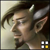
Whoop Whoop...after about a half year lay off im ready to begin again on this epic journey of making a map lol...after looking over past comments and concerns about my map i have switched it up quite a bit...please compare to last version which can be found on page 8 or in a link in the first post...i have changed the map to make better use of the room allotted yet i still feel there is to much dead space on the map...comments and concerns are always welcome!
- Click image to enlarge.

Re: War of the Roses Map (Version 13 p.9 comments please!)
War of the roses was all about kindoms - villages & castles...... Ya could include castles for each kindom & family crests would be cool (lots of color & neat shields) and I believe London and a couple other cities was of importance then & ya could do an auto deploy of 1 (like in europe 1914)too & ya could split S england and give ya another bonus area & increase wales value...... Nice work - cool idea 
This post was made by jefjef who should be on your ignore list.

drunkmonkey wrote:I'm filing a C&A report right now. Its nice because they have a drop-down for "jefjef".
-
sailorseal
- Posts: 2735
- Joined: Sun May 25, 2008 1:49 pm
- Gender: Male
- Location: conquerclub.com
Re: War of the Roses Map (Version 13 p.9 comments please!)
Could you define the borders more they are difficult to make out, I like the texture you have going but I think you have overused it, its hard to see most details maybe lighten up a little.
Re: War of the Roses Map (Version 13 p.9 comments please!)
By lighten up a little...do you mean lightening the parchment?sailorseal wrote:Could you define the borders more they are difficult to make out, I like the texture you have going but I think you have overused it, its hard to see most details maybe lighten up a little.