any more notices, except "natty´s" that settlements need be more differentiate?
Baltic Crusades
Moderator: Cartographers
Forum rules
Please read the Community Guidelines before posting.
Please read the Community Guidelines before posting.
-
theBastard

- Posts: 994
- Joined: Sat Jan 09, 2010 9:05 am
Re: Baltic Crusades - new Hanseatic towns
this is good, ender, so I will not must to learn make them... 
any more notices, except "natty´s" that settlements need be more differentiate?
any more notices, except "natty´s" that settlements need be more differentiate?
-
theBastard
- Posts: 994
- Joined: Sat Jan 09, 2010 9:05 am
Re: Baltic Crusades - new Hanseatic towns
....
Last edited by theBastard on Mon Dec 20, 2010 11:50 am, edited 1 time in total.
-
Industrial Helix

- Posts: 3462
- Joined: Mon Jul 14, 2008 6:49 pm
- Gender: Female
- Location: Ohio
Re: Baltic Crusades - edited Hanseatic towns
Is greater Poland, Novgorod and the HRE playable territories? If not, maybe you should fade their text a tad.
Konigsburg could use a slight glow to make it legible.
And I really liked how the trees were on Pork's version, perhaps you ought to borrow that idea.
As for the towns needing to look different... I think they look quite different, at least in shape. Shouldn't that be good enough?
Konigsburg could use a slight glow to make it legible.
And I really liked how the trees were on Pork's version, perhaps you ought to borrow that idea.
As for the towns needing to look different... I think they look quite different, at least in shape. Shouldn't that be good enough?
Sketchblog [Update 07/25/11]: http://indyhelixsketch.blogspot.com/
Living in Japan [Update 07/17/11]: http://mirrorcountryih.blogspot.com/
Russian Revolution map for ConquerClub [07/20/11]: http://www.conquerclub.com/forum/viewto ... 1&t=116575
Living in Japan [Update 07/17/11]: http://mirrorcountryih.blogspot.com/
Russian Revolution map for ConquerClub [07/20/11]: http://www.conquerclub.com/forum/viewto ... 1&t=116575
-
porkenbeans

- Posts: 2546
- Joined: Mon Sep 10, 2007 4:06 pm
Re: Baltic Crusades - edited Hanseatic towns
I saw an old map from this period that spelled Visby with a W. as in Wisby.

-
theBastard
- Posts: 994
- Joined: Sat Jan 09, 2010 9:05 am
Re: Baltic Crusades - edited Hanseatic towns
....
Last edited by theBastard on Mon Dec 20, 2010 11:50 am, edited 1 time in total.
-
porkenbeans
- Posts: 2546
- Joined: Mon Sep 10, 2007 4:06 pm
Re: Baltic Crusades - edited Hanseatic towns
Yeah, it is probably a case of the particular map makers language.Wisby, I saw it too, but I never found any source why is sometimes used Wisby. therefore I go with well known Visby.
I have been working on it, and will post something later today.pork, if you can do only a little wonder it would be great...
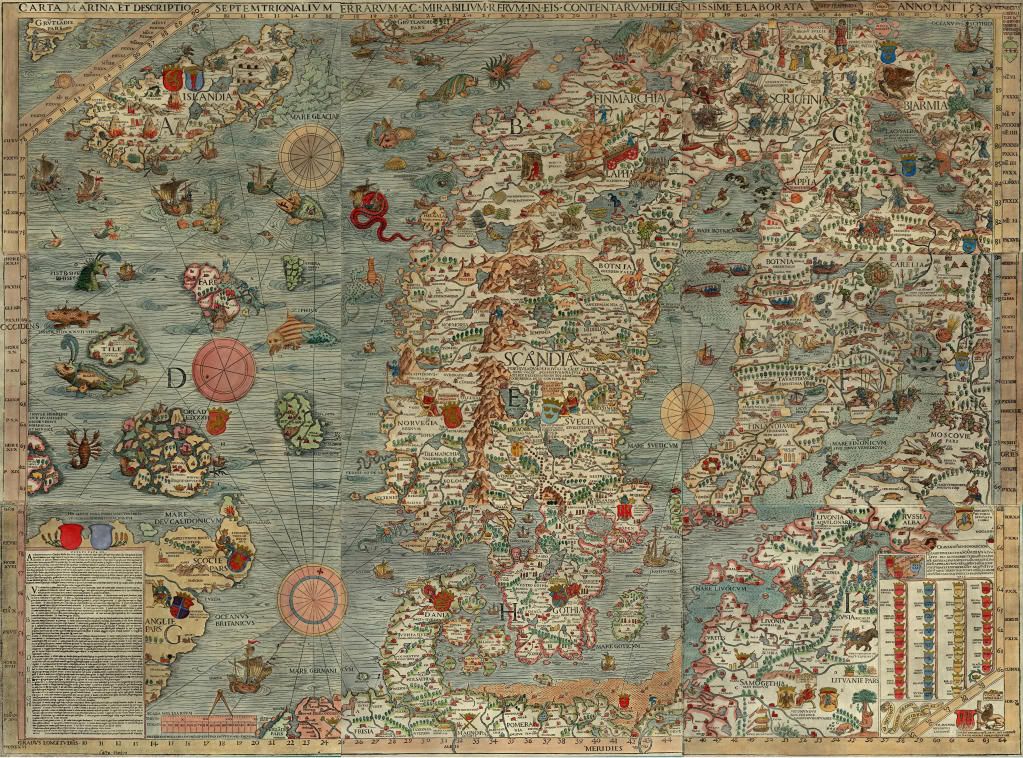
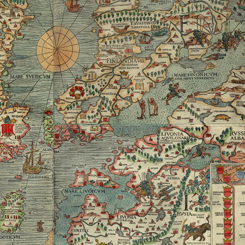
Have you ever seen this map ?
- Click image to enlarge.
- Click image to enlarge.
- Click image to enlarge.
-
theBastard
- Posts: 994
- Joined: Sat Jan 09, 2010 9:05 am
Re: Baltic Crusades - edited Hanseatic towns
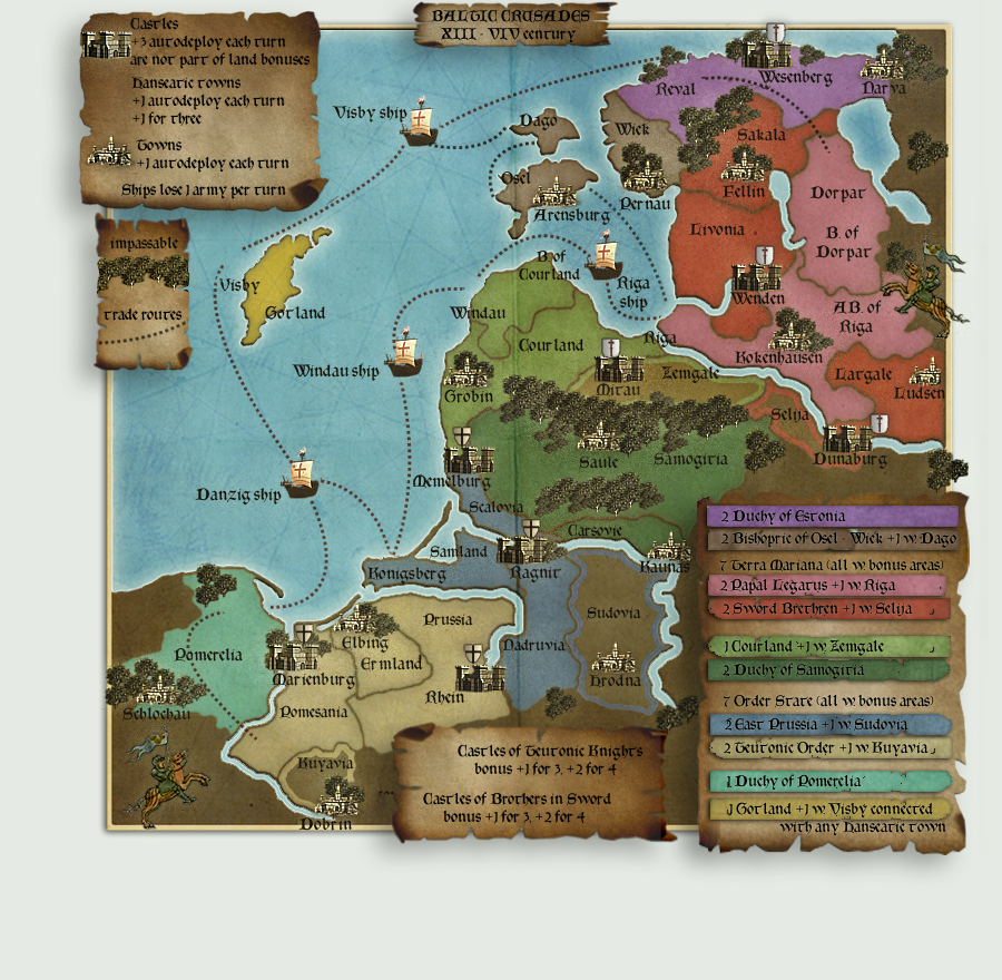
yes, yes, yes... I like it! only four notices:
1, it is too brightness, I think.
2, move legends "to the map´s size". they look off now.
3, maybe you could differentiate unplayable areas - they have now the same colour as borders.
4, why you lost some icons?
but I realy like it and riders look great... thanks.
about yours maps. I never saw them, but look interesting.
-
Industrial Helix
- Posts: 3462
- Joined: Mon Jul 14, 2008 6:49 pm
- Gender: Female
- Location: Ohio
Re: Baltic Crusades - edited Hanseatic towns
Yeah, I agree, its a tad too bright.
And whats with all the white space.
And whats with all the white space.
Sketchblog [Update 07/25/11]: http://indyhelixsketch.blogspot.com/
Living in Japan [Update 07/17/11]: http://mirrorcountryih.blogspot.com/
Russian Revolution map for ConquerClub [07/20/11]: http://www.conquerclub.com/forum/viewto ... 1&t=116575
Living in Japan [Update 07/17/11]: http://mirrorcountryih.blogspot.com/
Russian Revolution map for ConquerClub [07/20/11]: http://www.conquerclub.com/forum/viewto ... 1&t=116575
-
porkenbeans
- Posts: 2546
- Joined: Mon Sep 10, 2007 4:06 pm
Re: Baltic Crusades - edited Hanseatic towns
- Click image to enlarge.
I think that all of this helps greatly to lessen the over dominating legends, and bring the playable area of the map to the forefront.
I did NOT spend the necessary time to properly make the shields in the legend, but will do so if this version is adopted.
-
Industrial Helix
- Posts: 3462
- Joined: Mon Jul 14, 2008 6:49 pm
- Gender: Female
- Location: Ohio
Re: Baltic Crusades - edited Hanseatic towns
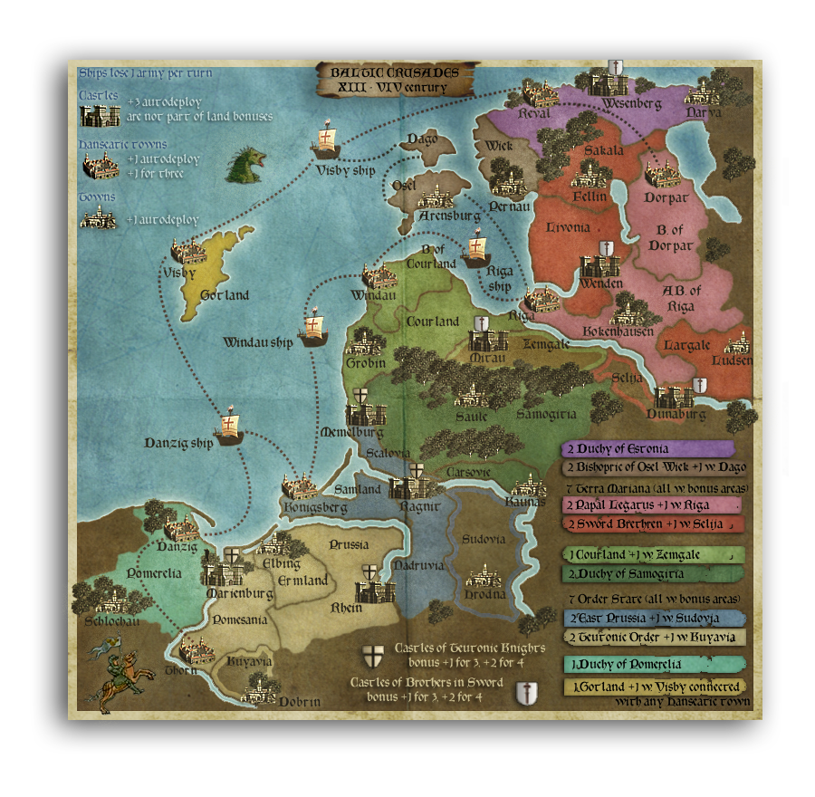
Generally I agree with you on the legends and I think that it fits nicely on the map itself. However, I think the regional bonuses could use a bounding box.
What happened to the new Hanseatic towns?
There are areas where the trees or a shield up north crosses into the border, I think you ought to cut them out of the border.
And what about some sort of road looking trail for the land routes that connect the towns? It seems like it might be a better idea than the very perfect photoshoped dotted line.
Sketchblog [Update 07/25/11]: http://indyhelixsketch.blogspot.com/
Living in Japan [Update 07/17/11]: http://mirrorcountryih.blogspot.com/
Russian Revolution map for ConquerClub [07/20/11]: http://www.conquerclub.com/forum/viewto ... 1&t=116575
Living in Japan [Update 07/17/11]: http://mirrorcountryih.blogspot.com/
Russian Revolution map for ConquerClub [07/20/11]: http://www.conquerclub.com/forum/viewto ... 1&t=116575
-
theBastard
- Posts: 994
- Joined: Sat Jan 09, 2010 9:05 am
Re: Baltic Crusades - edited Hanseatic towns
....
Last edited by theBastard on Mon Dec 20, 2010 11:48 am, edited 1 time in total.
Re: Baltic Crusades - edited Hanseatic towns
One question, one correction and one comment.
First off the map looks great, just down the road of my interests, I can't wait to play it.
Second, are the map sizes allowed? The guide says the height of the small map can not be taller than 600. I believe yours is 630.
Thirdly the roman numerals in the title says VIV rather than XIV.
First off the map looks great, just down the road of my interests, I can't wait to play it.
Second, are the map sizes allowed? The guide says the height of the small map can not be taller than 600. I believe yours is 630.
Thirdly the roman numerals in the title says VIV rather than XIV.


-
theBastard
- Posts: 994
- Joined: Sat Jan 09, 2010 9:05 am
Re: Baltic Crusades - edited Hanseatic towns
....
Last edited by theBastard on Mon Dec 20, 2010 11:49 am, edited 1 time in total.
Re: Baltic Crusades - edited Hanseatic towns
Yes. That's what I noticed. I always thought that it had to be the other way around, with maximum height being 800 or 600.theBastard wrote:the upper one has 840x800 size. the picture below is 630x600.tokle wrote: Second, are the map sizes allowed? The guide says the height of the small map can not be taller than 600. I believe yours is 630.
-
theBastard
- Posts: 994
- Joined: Sat Jan 09, 2010 9:05 am
Re: Baltic Crusades - edited Hanseatic towns
840 (630) width, 800 (600) height.
Re: Baltic Crusades - edited Hanseatic towns
Is it really? It looks taller than wide to me. I might be wrong...theBastard wrote:840 (630) width, 800 (600) height.
-
theBastard
- Posts: 994
- Joined: Sat Jan 09, 2010 9:05 am
Re: Baltic Crusades - edited Hanseatic towns
just download it and look 
Re: Baltic Crusades - edited Hanseatic towns
I'll take your word for it.theBastard wrote:just download it and look
Good job.
-
natty dread

- Posts: 12877
- Joined: Fri Feb 08, 2008 8:58 pm
- Location: just plain fucked
Re: Baltic Crusades - edited Hanseatic towns
It's an optical illusion due to the shape of your monitor. Your monitor is wider than it is tall, and when your eyes get used to looking at the monitor, you'll instinctively think anything that fits the shape of your monitor as "square" even when they're not. Conversely, a rectangle that is actually closer to a square, will look stretched...tokle wrote:Is it really? It looks taller than wide to me. I might be wrong...theBastard wrote:840 (630) width, 800 (600) height.
That is, if you're not actually using some weird display mode that has non-square pixels.

-
theBastard
- Posts: 994
- Joined: Sat Jan 09, 2010 9:05 am
Re: Baltic Crusades - edited Hanseatic towns
....
Last edited by theBastard on Mon Dec 20, 2010 11:49 am, edited 1 time in total.
-
Industrial Helix
- Posts: 3462
- Joined: Mon Jul 14, 2008 6:49 pm
- Gender: Female
- Location: Ohio
Re: Baltic Crusades - lets finalize it
You're going to have to make the red lines a little more visible on the latest image.
Sketchblog [Update 07/25/11]: http://indyhelixsketch.blogspot.com/
Living in Japan [Update 07/17/11]: http://mirrorcountryih.blogspot.com/
Russian Revolution map for ConquerClub [07/20/11]: http://www.conquerclub.com/forum/viewto ... 1&t=116575
Living in Japan [Update 07/17/11]: http://mirrorcountryih.blogspot.com/
Russian Revolution map for ConquerClub [07/20/11]: http://www.conquerclub.com/forum/viewto ... 1&t=116575
-
theBastard
- Posts: 994
- Joined: Sat Jan 09, 2010 9:05 am
Re: Baltic Crusades - lets finalize it
....
Last edited by theBastard on Mon Dec 20, 2010 11:46 am, edited 1 time in total.
-
natty dread
- Posts: 12877
- Joined: Fri Feb 08, 2008 8:58 pm
- Location: just plain fucked
-
theBastard
- Posts: 994
- Joined: Sat Jan 09, 2010 9:05 am
Re: Baltic Crusades - lets finalize it
....
Last edited by theBastard on Mon Dec 20, 2010 11:47 am, edited 1 time in total.
-
Industrial Helix
- Posts: 3462
- Joined: Mon Jul 14, 2008 6:49 pm
- Gender: Female
- Location: Ohio
Re: Baltic Crusades - lets finalize it
Yes, much better.
Other crits I have are that the lake over where Estonia is now could use the same border treatment as the rest of the map. And upon looking that way, I noticed that your eastern most border could use a redraw as its all uneven and pixely.
I'd also recommend that you adopt something along the lines that Porkenbean did for the inset legends. It really cleared up the map in my opinion and this version could benefit from it.
One other thing I liked from his version was how places which are not playable were omitted from being labeled, such as Greater Poland and Holy Roman Empire.
Sketchblog [Update 07/25/11]: http://indyhelixsketch.blogspot.com/
Living in Japan [Update 07/17/11]: http://mirrorcountryih.blogspot.com/
Russian Revolution map for ConquerClub [07/20/11]: http://www.conquerclub.com/forum/viewto ... 1&t=116575
Living in Japan [Update 07/17/11]: http://mirrorcountryih.blogspot.com/
Russian Revolution map for ConquerClub [07/20/11]: http://www.conquerclub.com/forum/viewto ... 1&t=116575