USA 2.1 [10 Mar 2013] Beta Baby!!
Moderator: Cartographers
Forum rules
Please read the Community Guidelines before posting.
Please read the Community Guidelines before posting.
Re: Mega USA Map [5 Nov 2011] V11 pg 10
I think +1 for every 5 with a minimum of 5 would be the best. I am ready to play this map and I will help you all I can when you make it a beta map.

Re: Mega USA Map [5 Nov 2011] V11 pg 10
Just put a maximum of 15 troops gained through holding territs without bonuses and keep it to 3 troops for 1 region, 4 for 12, 5 for 15 etc. 45 regions gives you 15 troops and 48 or 108 does not give you more. That way 1v1 will be all about holding bonuses not taking down random territs and total number of territs still matters in large games.
AoG for President of the World!!
I promise he will put George W. Bush to shame!
I promise he will put George W. Bush to shame!
Re: Mega USA Map [5 Nov 2011] V11 pg 10
So basically a minimum of 3 and a max of 15? I'm thinking this is along what I was thinking of. Anyways here is a small update. I moved the instructions that were up withe the mini-map down to the bottom left corner and placed a border around it. I also put a border around the Interstate bonus. Will update OP later.Gillipig wrote:Just put a maximum of 15 troops gained through holding territs without bonuses and keep it to 3 troops for 1 region, 4 for 12, 5 for 15 etc. 45 regions gives you 15 troops and 48 or 108 does not give you more. That way 1v1 will be all about holding bonuses not taking down random territs and total number of territs still matters in large games.
- Click image to enlarge.

-
ViperOverLord

- Posts: 2495
- Joined: Sun Apr 19, 2009 3:19 pm
- Location: California
Re: Mega USA Map [5 Nov 2011] V11 pg 10
I'll give it some thought and get back to you.isaiah40 wrote:Any suggestions for the bonuses? One suggestion was to have it +1 for every 5 territories, while another was to limit the reinforcements to a max of like 15. So you would get a max of 15 plus whatever bonus you hold.ViperOverLord wrote:I love it the concept and application. I wonder about the bonus structure though. It seems like bonuses could rack up fast and make for a lot of one sided games.
-
natty dread

- Posts: 12876
- Joined: Fri Feb 08, 2008 8:58 pm
- Location: just plain fucked
Re: Mega USA Map [7 Nov 2011] V12 pg 11
I know I've posted about this before, but... I would still advocate de-clutterifying the visual style of the map further.
I mean, there's just so much stuff on that image! Lines, circles, stars, text... it looks like, I don't know how to put it... you know when you get to a new city and try to make sense of the local public transportation... and you look at the maps and you're like "where the hell am I"?
So any way to simplify the visuals here, to make the overall look less cluttered, would be plus for this map.
I know you want to remain faithful to the style of the previous USA maps, but is it really worth it to dogmatically follow a style that isn't necessarily optimal for this project? Besides, you wouldn't have to abandon it altogether. Just make it a bit easier to follow.
For one thing, I don't think the gaps between the states are necessary. They only serve to increase the amount of lines (you have two lines for each state border, where you could do with just one) which increases clutter. For another, you could make the connecting lines thinner. Even doing these two things could do wonders for the visual clarity & readability of the map.

Re: Mega USA Map [7 Nov 2011] V12 pg 11
While I would agree with you on these points, I will disagree with you for the most part. First, If I do this like a normal map, we will run into the problem of the New England area where we have very small states such as Rhode Island - which last time I read, only had like 12 State Police cars -and Connecticut, New Hampshire, etc. That area will be totally cluttered if I removed the gaps. I know that you will say to use an inset for that area, but where would I put it? I could take out Alaska and Hawaii, but then this wouldn't be a true Mega USA map. So I don't think It is feasible to go down that road. Secondly, the Interstate highways I could probably reduce them down by 1 px in width. I will do this thing and see how it turns out. Remember I am already at the max supersize small at 1000x800, so I have to work within these dimensions.natty_dread wrote:For one thing, I don't think the gaps between the states are necessary. They only serve to increase the amount of lines (you have two lines for each state border, where you could do with just one) which increases clutter. For another, you could make the connecting lines thinner. Even doing these two things could do wonders for the visual clarity & readability of the map.
Re: Mega USA Map [7 Nov 2011] V12 pg 11
isaiah40 wrote:While I would agree with you on these points, I will disagree with you for the most part. First, If I do this like a normal map, we will run into the problem of the New England area where we have very small states such as Rhode Island - which last time I read, only had like 12 State Police cars -and Connecticut, New Hampshire, etc. That area will be totally cluttered if I removed the gaps. I know that you will say to use an inset for that area, but where would I put it? I could take out Alaska and Hawaii, but then this wouldn't be a true Mega USA map. So I don't think It is feasible to go down that road. Secondly, the Interstate highways I could probably reduce them down by 1 px in width. I will do this thing and see how it turns out. Remember I am already at the max supersize small at 1000x800, so I have to work within these dimensions.natty_dread wrote:For one thing, I don't think the gaps between the states are necessary. They only serve to increase the amount of lines (you have two lines for each state border, where you could do with just one) which increases clutter. For another, you could make the connecting lines thinner. Even doing these two things could do wonders for the visual clarity & readability of the map.
What your suggesting is quite a major change ... IMO the map looks wonderful as it is ... The gaps between the states help make this an easier reading map , considering all that is going on ... Cant wait to play , my new favorite map

Re: Mega USA Map [5 Nov 2011] V11 pg 10
I would rather see a setup where you get a troop every 4 terts instead of 3. So at 30, you're getting 7 instead of 10. And you could put a cap on that as well if you wanted to.isaiah40 wrote:Any suggestions for the bonuses? One suggestion was to have it +1 for every 5 territories, while another was to limit the reinforcements to a max of like 15. So you would get a max of 15 plus whatever bonus you hold.ViperOverLord wrote:I love it the concept and application. I wonder about the bonus structure though. It seems like bonuses could rack up fast and make for a lot of one sided games.
Re: Mega USA Map [7 Nov 2011] V12 pg 11
One advantage with having gaps in between states is that bonuses are easier to detect.isaiah40 wrote:While I would agree with you on these points, I will disagree with you for the most part. First, If I do this like a normal map, we will run into the problem of the New England area where we have very small states such as Rhode Island - which last time I read, only had like 12 State Police cars -and Connecticut, New Hampshire, etc. That area will be totally cluttered if I removed the gaps. I know that you will say to use an inset for that area, but where would I put it? I could take out Alaska and Hawaii, but then this wouldn't be a true Mega USA map. So I don't think It is feasible to go down that road. Secondly, the Interstate highways I could probably reduce them down by 1 px in width. I will do this thing and see how it turns out. Remember I am already at the max supersize small at 1000x800, so I have to work within these dimensions.natty_dread wrote:For one thing, I don't think the gaps between the states are necessary. They only serve to increase the amount of lines (you have two lines for each state border, where you could do with just one) which increases clutter. For another, you could make the connecting lines thinner. Even doing these two things could do wonders for the visual clarity & readability of the map.
AoG for President of the World!!
I promise he will put George W. Bush to shame!
I promise he will put George W. Bush to shame!
-
MarathonMax
- Posts: 74
- Joined: Tue Dec 16, 2008 2:47 pm
- Gender: Male
Re: Mega USA Map [7 Nov 2011] V12 pg 11
Where do I sign to beta this this one?
Decadent!
Just decadent!
Decadent!
Just decadent!
-
ViperOverLord
- Posts: 2495
- Joined: Sun Apr 19, 2009 3:19 pm
- Location: California
Re: Mega USA Map [5 Nov 2011] V11 pg 10
My bad. This slipped my mind. I will be looking at it though.ViperOverLord wrote:I'll give it some thought and get back to you.isaiah40 wrote:Any suggestions for the bonuses? One suggestion was to have it +1 for every 5 territories, while another was to limit the reinforcements to a max of like 15. So you would get a max of 15 plus whatever bonus you hold.ViperOverLord wrote:I love it the concept and application. I wonder about the bonus structure though. It seems like bonuses could rack up fast and make for a lot of one sided games.
-
ViperOverLord
- Posts: 2495
- Joined: Sun Apr 19, 2009 3:19 pm
- Location: California
Re: Mega USA Map [5 Nov 2011] V11 pg 10
Okay. To refresh, this map has plus 3 for Vermont and plus 4 for SC. Possibly those bonuses are too large. But even if they were small, it could be a detriment (especially 1 v 1) for a an opponent to start with 3 or 4 bonuses and go first. I think a viable solution would be to make the bonuses smaller and consider having all Capitals have 3 neut on them and be auto-deploy 1 for when a player captures them.ViperOverLord wrote:I'll give it some thought and get back to you.isaiah40 wrote:Any suggestions for the bonuses? One suggestion was to have it +1 for every 5 territories, while another was to limit the reinforcements to a max of like 15. So you would get a max of 15 plus whatever bonus you hold.ViperOverLord wrote:I love it the concept and application. I wonder about the bonus structure though. It seems like bonuses could rack up fast and make for a lot of one sided games.
On a lesser note, I'd rename Dallas DFW and put an airport there. That is a huge airport in a huge state. I'd consider more airports in general.
-
lostatlimbo

- Posts: 1386
- Joined: Wed Mar 28, 2007 3:56 pm
- Location: Portland, OR
Re: Mega USA Map [7 Nov 2011] V12 pg 11
Some thoughts:
- I love the helicopters in Alaska - smart!
- The airport icons in NY & ATL are a little lost. You may want to consider making these a different color than black or at least giving them a stroke or halo effect. I think those will frustrate some folks, because even if you read the legend, it will be easy to forget them with so much going on.
- The bonus legend up top looks awkward. I see that it doesn't fit together in that space, but I think you could make that part a bit smaller. You'd have to offset some of the New England bonus text, but something to toy with perhaps.
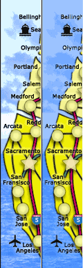
- At first, I agreed with Natty about the spaces between states, then I agreed with isaiah, now I realize the issue is not spaces, but background. There's too much contrast. I know you're going for the same look as the regional USA maps, but this still has more contrast than those. I think if you make the background photo a little more uniform it will help a great deal!
- Lastly, are you married to the title? Mega USA seems... meh. What about USA 2.0? United States? 50 States? Too bad we can't rename the old USA map to "Doodle USA" and give this one the USA name. :)
-
AndyDufresne

- Posts: 24919
- Joined: Fri Mar 03, 2006 8:22 pm
- Location: A Banana Palm in Zihuatanejo
- Contact:
Re: Mega USA Map [7 Nov 2011] V12 pg 11
I think lostalimbo might be onto something in regards to the background.lostatlimbo wrote:Some thoughts:
- At first, I agreed with Natty about the spaces between states, then I agreed with isaiah, now I realize the issue is not spaces, but background. There's too much contrast. I know you're going for the same look as the regional USA maps, but this still has more contrast than those. I think if you make the background photo a little more uniform it will help a great deal!
--Andy
Re: Mega USA Map [7 Nov 2011] V12 pg 11
I hadn't really thought about the background until I read this. But there may be something to this. Try how it looks with a single tone of colour.AndyDufresne wrote:I think lostalimbo might be onto something in regards to the background.lostatlimbo wrote:Some thoughts:
- At first, I agreed with Natty about the spaces between states, then I agreed with isaiah, now I realize the issue is not spaces, but background. There's too much contrast. I know you're going for the same look as the regional USA maps, but this still has more contrast than those. I think if you make the background photo a little more uniform it will help a great deal!
--Andy
AoG for President of the World!!
I promise he will put George W. Bush to shame!
I promise he will put George W. Bush to shame!
Re: Mega USA Map [5 Nov 2011] V11 pg 10
This could be an idea. The bonuses might have to be lower because of the amount of bonuses, but before I do I would like to hear from others.ViperOverLord wrote:Okay. To refresh, this map has plus 3 for Vermont and plus 4 for SC. Possibly those bonuses are too large. But even if they were small, it could be a detriment (especially 1 v 1) for a an opponent to start with 3 or 4 bonuses and go first. I think a viable solution would be to make the bonuses smaller and consider having all Capitals have 3 neut on them and be auto-deploy 1 for when a player captures them.
Yes I can do this. As for adding in more airports, I don't want to clutter the map with too many of them. I'm thinking that DFW would be the last airport I'd add.ViperOverLord wrote:On a lesser note, I'd rename Dallas DFW and put an airport there. That is a huge airport in a huge state. I'd consider more airports in general.
Thanks lostatlimbo! Yea I can change the color of the airport symbol to make them stand out more. The mini-map, it's on the block to be redone as I don't like how big it is myself. No I'm not married to the title. I kind of like 50 States - besides it would put it right up underneath Classic when you start a new game.lostatlimbo wrote:Some thoughts:
I wasn't all that into the idea at first, but its really coming along well and it is so much better than the current US map. Well done, isaiah. Hope this makes it to Beta soon, as I'd love to use it in some tourneys.
- I love the helicopters in Alaska - smart!
- The airport icons in NY & ATL are a little lost. You may want to consider making these a different color than black or at least giving them a stroke or halo effect. I think those will frustrate some folks, because even if you read the legend, it will be easy to forget them with so much going on.
- The bonus legend up top looks awkward. I see that it doesn't fit together in that space, but I think you could make that part a bit smaller. You'd have to offset some of the New England bonus text, but something to toy with perhaps.
- Lastly, are you married to the title? Mega USA seems... meh. What about USA 2.0? United States? 50 States? Too bad we can't rename the old USA map to "Doodle USA" and give this one the USA name.
When I read losatlimbo's post I though about doing this. Great minds think alike!Gillipig wrote:I hadn't really thought about the background until I read this. But there may be something to this. Try how it looks with a single tone of colour.AndyDufresne wrote:I think lostalimbo might be onto something in regards to the background.lostatlimbo wrote:Some thoughts:
- At first, I agreed with Natty about the spaces between states, then I agreed with isaiah, now I realize the issue is not spaces, but background. There's too much contrast. I know you're going for the same look as the regional USA maps, but this still has more contrast than those. I think if you make the background photo a little more uniform it will help a great deal!
--Andy
Re: Mega USA Map [7 Nov 2011] V12 pg 11
Changes made:
1. Changed title to 50 States.
2. Shrank down mini-map
3. changed background to single color
4. Reduced Interstates by 1px
5. Changed Airport symbols from black to red
6. Added 2 more airports - Dallas & Denver
Things to do:
1. A whole lot
Small
1. Changed title to 50 States.
2. Shrank down mini-map
3. changed background to single color
4. Reduced Interstates by 1px
5. Changed Airport symbols from black to red
6. Added 2 more airports - Dallas & Denver
Things to do:
1. A whole lot
Small
- Click image to enlarge.

-
koontz1973
- Posts: 6960
- Joined: Thu Jan 01, 2009 10:57 am
Re: 50 States (was Mega USA Map) [16 Nov 2011] V13 pg 12
The background helps with the clarity overall but looks as if something is missing. That could be this is the first time I am seeing it and am used to the sky background.
Mini map looks really nice now.
The red for the airplanes are too bright. I would try to find a colour that you could use for all 3 of your symbols. No suggestions as of now.
Interstates are going to be the biggest problem on the small map. It is hard to see some of them as it was and now you have made them smaller. It might be nice to increase the colour some to make them stand out more.
Why 50 States and not Mega USA? It sounds ordinary now.
Just some thoughts
Am going to look at this tonight on my TV to see it a lot more clearly.

-
lostatlimbo
- Posts: 1386
- Joined: Wed Mar 28, 2007 3:56 pm
- Location: Portland, OR
Re: 50 States (was Mega USA Map) [16 Nov 2011] V13 pg 12
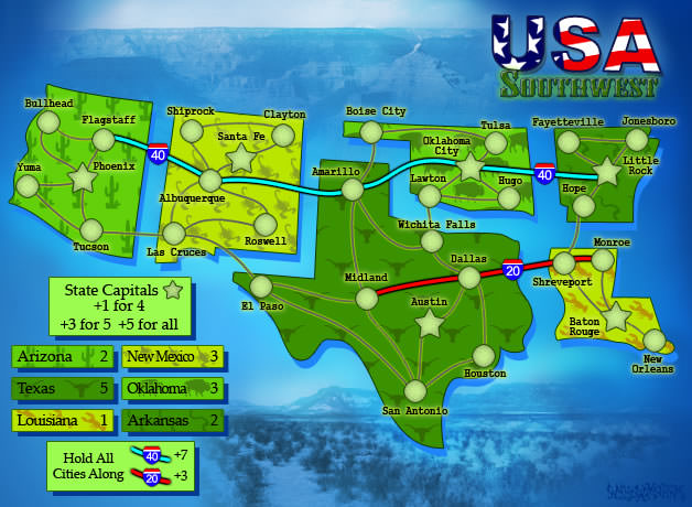
The mini map looks great and the solid background definitely helps - a lot of elements stand out better now (like the white house on DC - I missed that before). However, I think there is a happy balance between this and the sky you had before. The regional maps fade their photos into the solid background: http://maps.conquerclub.com/USA_Southwest.S.jpg You could try that and maybe do ocean on one part and land on the other? Or keep even your background and take down the contrast?
I like the new title! Its fitting as the only map that shows all 50 and because they are all separated a little, you really see the 50 well. Good call.
For the plane icons, if you don't like red, what about white with a black border? Closer to the same look as the others that way.
I agree with koontz that the freeways are tough now. How do they look without the black on either side at that size? It looks like that is what is making them darker. Without borders, the blues might be tough to spot in the Rockies, but you could swap some colors around (perhaps).
$.02
Re: Mega USA Map [5 Nov 2011] V11 pg 10
After looking at the two for a while I think the single colour version is easier on the eye. For me it's only the sky part that hurts, not the ocean. Try how the American flag would look like as background image. Might be cool and might crap. Worth trying thoughisaiah40 wrote:
- Click image to enlarge.
- Click image to enlarge.
AoG for President of the World!!
I promise he will put George W. Bush to shame!
I promise he will put George W. Bush to shame!
-
natty dread
- Posts: 12876
- Joined: Fri Feb 08, 2008 8:58 pm
- Location: just plain fucked
Re: Mega USA Map [7 Nov 2011] V12 pg 11
No it wouldn't, you wouldn't have to move the current states, just fill out the gaps.isaiah40 wrote:While I would agree with you on these points, I will disagree with you for the most part. First, If I do this like a normal map, we will run into the problem of the New England area where we have very small states such as Rhode Island - which last time I read, only had like 12 State Police cars -and Connecticut, New Hampshire, etc. That area will be totally cluttered if I removed the gaps.natty_dread wrote:For one thing, I don't think the gaps between the states are necessary. They only serve to increase the amount of lines (you have two lines for each state border, where you could do with just one) which increases clutter. For another, you could make the connecting lines thinner. Even doing these two things could do wonders for the visual clarity & readability of the map.
You're wrong, I won't say that.I know that you will say to use an inset for that area
But remember, geographical accuracy isn't the priority here. If you can improve readability by twisting the geography somewhat, it's a good trade.
-
ViperOverLord
- Posts: 2495
- Joined: Sun Apr 19, 2009 3:19 pm
- Location: California
Re: 50 States (was Mega USA Map) [16 Nov 2011] V13 pg 12
-- Adding regional airports that can only fly two states away. I tend to agree with you that you don't want to clutter the map with airports though.
-- I didn't hear if you didn't like the idea of state capitals being neutral to start and being auto-deploys when captured. Even if you don't like that idea, I'd look into where the major military installations in the USA are (San Diego for example) and I would consider creating icons and having the military installations being plus one auto deploys.
-- Potential nuclear facilities and giving them the power to bomard up to 2 or 3 states away.
--The abilities of ports to attack. I don't have a specific concept, just spit balling that out there.
--What about the Mississippi River? That's a major US supply line. I'd consider putting that in there and having an auto deploy bonus given to New Orleans if a player holds the entire river.
-- I still think the bonus system is whack! You can go with those huge bonuses, but then you'll quickly find out that people will be complaining about getting blown out from the start. And I think even with the smaller state bonuses that I initially proposed, that it would still be a problem as with 50 States even with small bonuses can add up really fast (Not to mention if a player holds just one huge highway bonus with them).
I have a comprehensive solution to the potential bonus issues.
Get rid of the various differentiating state bonuses and create regional bonuses.
Argument: But won't that detract from the 50 State Concept.
Answer/Solution: No, because each state, regardless of size can still carry a plus one bonus. Therefore if a person holds a few states, the value of states is real modest state bonuses won't throw the game off kilter.
Argument: Would you not then have to color code the bonuses by region, and make the map much more bland and detract from the 50 State heritage?
Answer/Solution: The key would be uniform colors for regions, but the map itself could remain individualized by state.
Argument: But wouldn't different color of states and colors for the regional bonuses not only be tacky but confusing?
Answer/Solution: Yes and no. Yes if the color shades don't match obviously. But certainly if you had a regional blue bonus then all the states in that bonus could have different shades of blue.
I think an even better change would be to have the regional bonuses in the key, but to make the states in individual picture formats. The pictures would show landmarks or people unique to a state. I think if done well, it could actually make the map look much fresher too!
--Lastly, those highway bonuses are just crazy. One highway bonus and a game could be all but over. Right now, the highway bonuses are one per city on that freeway (having to hold all cities of course). I'd consider making it 2 cities per 1 deploy and rounding down for odd values. So for instance the 17 bonus for holding the 10 highway would now be an 8 bonus.
-
AndyDufresne
- Posts: 24919
- Joined: Fri Mar 03, 2006 8:22 pm
- Location: A Banana Palm in Zihuatanejo
- Contact:
Re: 50 States (was Mega USA Map) [16 Nov 2011] V13 pg 12
Of the items you mention in your post, only the above would I be interested in seeing it possibly implemented on the map.ViperOverLord wrote: Get rid of the various differentiating state bonuses and create regional bonuses.
Argument: But won't that detract from the 50 State Concept.
Answer/Solution: No, because each state, regardless of size can still carry a plus one bonus. Therefore if a person holds a few states, the value of states is real modest state bonuses won't throw the game off kilter.
Argument: Would you not then have to color code the bonuses by region, and make the map much more bland and detract from the 50 State heritage?
Answer/Solution: The key would be uniform colors for regions, but the map itself could remain individualized by state.
Argument: But wouldn't different color of states and colors for the regional bonuses not only be tacky but confusing?
Answer/Solution: Yes and no. Yes if the color shades don't match obviously. But certainly if you had a regional blue bonus then all the states in that bonus could have different shades of blue.
I think an even better change would be to have the regional bonuses in the key, but to make the states in individual picture formats. The pictures would show landmarks or people unique to a state. I think if done well, it could actually make the map look much fresher too!
--Andy
-
lostatlimbo
- Posts: 1386
- Joined: Wed Mar 28, 2007 3:56 pm
- Location: Portland, OR
Re: 50 States (was Mega USA Map) [16 Nov 2011] V13 pg 12
I have to disagree with most of what ViperOverLord suggests. There is already a lot going on here and I think it would be overkill to add military bases, nuclear reactors, etc. I don't see how any of that would benefit the map.
Regarding state/regional bonuses - I don't really see what the problem is, nor do I think that solution would help. Holding NY for 1 troop would be a waste. There might be a few state bonuses that need to be tweaked, but overall, I think its pretty solid distribution for what a player must hold and defend.
It seems the main issue Viper has with 1v1 games and this clearly isn't an ideal map for that. World 2.1 and other super maps have the same problem. I don't think isiah should dismantle his gameplay just for 1v1 gameplay (and I say that as someone who plays 1v1 90% of the time).
I also disagree on highways. There are very few "protected' territories along those highway bonuses and on most you'd have to defend the same number of territories as the bonus is worth - which is rarely an effective strategy. In fact, I doubt these will be used in most games, except when the game is nearly at end. They are not nearly the game changer Viper suggests.
There will need to be some care taken into evening out drops with neutrals and such, but I don't think this should be overhauled. I think it will work fine.
Re: 50 States (was Mega USA Map) [16 Nov 2011] V13 pg 12
Thanks viper and lost. Though vipers suggestions seem to be workable, as lost mentioned, I'm not in favor of totally changing the game play.
If you hold (and are capable of holding) say Interstate 10 (the bottom Interstate) for +17, you have to defend it form 21 other cities, which IMO is pretty fair. In contrast Interstate 95 - the far right one - you get +24, and you have to defend against 30 other cities. 6 of those cities do not have to defend against another city - and this is if you hold the entire interstate.
As for the bonus regions, I already have them. There are 7 of them:
1. New England
2. Southeast
3. Great Lakes
4. Rocky Mountains
5. Southwest
6. Western
7. Pacific
The bonus values for these are the total of the state bonuses plus 2. I agree with lostatlimbo that some of the bonuses will have to be tweaked, but that is this part of the main foundry is for. For this map I am really thinking that having a cap on # of troops you get is the way to go. I am strongly favoring 1 per 5 with a cap of 15 and minimum of 3. We could have the regional bonuses override the state bonuses to reduce the amount of men you receive. This means that you will need to hold 65 territories to receive those 15 men. For example - with the regional bonus override - you only hold Southeast with no men anywhere else, that will bring you +30 for the regional bonus, Southeast has 30 territories so that will bring you another 8 men for a total of 38 men. I'm thinking that is this is very fair, and won't allow anyone to win early in the game - not that this is going to happen on this map.
Now as far as neutrals and such. I can make every capital including DC start with 3 neutral. DC will have a +2 autodeploy, and the cities can have a +1 auto. So for our example above, that player would also receive 7 men place don the capitals. Along with the capitals starting neutral, I think that the airports, heliports, and ferry terminals should also start as neutral 3. This make 63 territories starting as neutral.
Territory Breakdown - Capitals and all Airports, Heliports, Ferries and DC start neutral
244 territories
64 start neutral - 180 left over for deployment
2 player = 90 starting territories = receive 15 men - need to lose 26 territories to receive 1 less
3 player = 60 starting territories = receive 14 men - need to lose 1 territory to receive 1 less
4 player = 45 starting territories = receive 11 men - need to lose 1 territory to receive 1 less
5 player = 36 starting territories = receive 9 men - need to lose 3 territories to receive 1 less
6 player = 30 starting territories = receive 8 men - need to lose 1 territory to receive 1 less
7 player = 25 starting territories = receive 7 men - need to lose 1 territory to receive 1 less
8 player = 22 starting territories = receive 6 men - need to lose 4 territories to receive 1 less
Territory Breakdown - Capitals and DC start neutral
244 territories
51 start neutral - 193 left over for deployment
2 player = 96 starting = receive 15 men - need to lose 31 territories to receive 1 less
3 player = 64 starting = receive 14 men - need to lose 4 territories to receive 1 less
4 player = 48 starting = receive 11 men - need to lose 4 territories to receive 1 less
5 player = 38 starting = receive 9 men - need to lose 4 territories to receive 1 less
6 player = 32 starting = receive 8 men - need to lose 3 territories to receive 1 less
7 player = 27 starting = receive 7 men - need to lose 3 territories to receive 1 less
8 player = 24 starting = receive 6 men - need to lose 5 territories to receive 1 less
So it looks like if I make all capitals start neutral including DC then this is the optimum way to start the game.
Anyways changes are as follows:
1. Placed the US flag as the background
2. Changed the Interstates - removed the outer glow on them and changed some of the colors
3. Renamed the map Mega USA as it sounds and looks better on the map
- Click image to enlarge.
