San Francisco [Quenched]
Moderator: Cartographers
Forum rules
Please read the Community Guidelines before posting.
Please read the Community Guidelines before posting.


-less 'elbowy'
-less transparent army circles
my new site - http://www.spritestitch.com/ - A video game craft weblog...
-
luckiekevin

- Posts: 272
- Joined: Fri Oct 13, 2006 10:08 pm
- Location: California
-
luckiekevin
- Posts: 272
- Joined: Fri Oct 13, 2006 10:08 pm
- Location: California

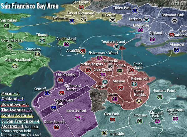
The route from Alameda to China Basin is a very smoooth curve, while the route from Emeryville to Alcatraz goes kinda straight for a ways, then turns kinda suddenly... like an elbow. I thought it was pretty clear?luckiekevin wrote:que?Can we get a smooth path for the Emeryville->Alcatraz ferry route? It is a little 'elbowy'.
Did you make all of the shadows less transparent? I think Keyogi just meant the faint ones. Now some of them seem to bright/white. Between the two I prefer the first more subtle version (the army numbers are pretty obvious either way I think).
On the first version these shadows looked faint to me: Corte Madera, El Cerrito, San Pablo, Tiberon, Sausalito; and to a lesser extent: Inner Sunset, McLaren Park, Bernal heights and Candlestick. Actually, all of the east bay shadows seem a bit fainter than all the SFs; maybe I've looked at it to long now; must rest my eyes!
yeahDid you make all of the shadows less transparent?
all the shadows are the same...they just 'appear' to be fainter in spots because of the city underneath being different colors...id rather not go in and change each individually...
i can go either way...
my new site - http://www.spritestitch.com/ - A video game craft weblog...

-
AndyDufresne

- Posts: 24919
- Joined: Fri Mar 03, 2006 8:22 pm
- Location: A Banana Palm in Zihuatanejo
- Contact:

I zoomed in nice and close on these and im almost positive that they are all perfectly centered...almost...well...are they?
only posting the images with armies because this is a xml only change...
my new site - http://www.spritestitch.com/ - A video game craft weblog...
-
wrightfan123

- Posts: 601
- Joined: Sat Jan 06, 2007 2:58 pm
- Gender: Male
- Location: Looking over every baseball team's schedule to try to determine who will win the World Series.
- Contact:
good catch. i dropped it a pixel.in the big map, the civic center army numbers are a bit high
my new site - http://www.spritestitch.com/ - A video game craft weblog...

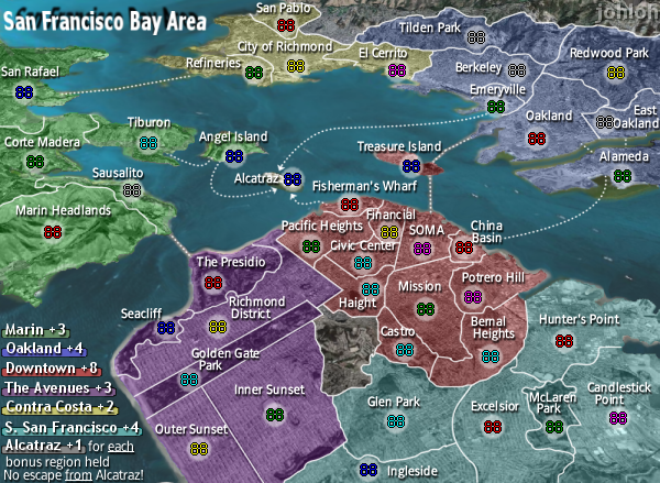
Fixed these three coords...xml only update...
Some coordinates that look out to me:
Small
- Sausalito
Large
- Mission
- Civic Centre
my new site - http://www.spritestitch.com/ - A video game craft weblog...
im totally sick of my map...that means i have atleast another month to go right?
my new site - http://www.spritestitch.com/ - A video game craft weblog...

-
cheguevarra
- Posts: 12
- Joined: Sat Jan 20, 2007 10:17 pm
yeah I know...im just complaining...I already got a good idea for my next map...but I dont want to start till im done with this one...
my new site - http://www.spritestitch.com/ - A video game craft weblog...
-
luckiekevin
- Posts: 272
- Joined: Fri Oct 13, 2006 10:08 pm
- Location: California
-
AndyDufresne
- Posts: 24919
- Joined: Fri Mar 03, 2006 8:22 pm
- Location: A Banana Palm in Zihuatanejo
- Contact:
-
luckiekevin
- Posts: 272
- Joined: Fri Oct 13, 2006 10:08 pm
- Location: California
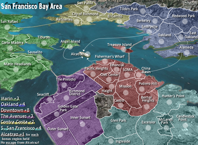
you mean on the smaller map right?AndyDufresne wrote:It's looking nice! I'll give it a real look over soon. The only thing I'd consider altering would be perhaps make 'no escape from alactraz' somehow more noticeable, either with slight boldness or color, but that is just a minor thing. And it may just ruin the flow of the legend.
--Andy
-
TroyMcClure

- Posts: 88
- Joined: Mon Feb 19, 2007 8:05 am
- Location: Springfield
- Contact:
Re: San Francisco (another xml update - bot 31) [Final Forge
great looking map, looking forward to trying it.