Scotland [Quenched]
Moderator: Cartographers
Forum rules
Please read the Community Guidelines before posting.
Please read the Community Guidelines before posting.


the changes to the hills and borders makes things a lot clearer now. i don’t know a way of improving the look of the hills.
four for the cities seems fair. the only one of the few maps i’ve actually played that has something similar (but not the same) is the philipiines map, which gives a +1 bonus for holding all three naval bases (but it’s far easier to hold three than four); the +1 played no part in my game because +1 wasn’t really worth having, considering that i’d have lost armies trying to take it.
the small arial font works well with the “scottish-looking” colours that u’ve chosen. if u tone down the colours too much, then u can’t use white letters.
ian.
-
DiM

- Posts: 10415
- Joined: Wed Feb 14, 2007 6:20 pm
- Gender: Male
- Location: making maps for scooby snacks
hereBalsiefen wrote:Thank you, i may try out some army shadows now.
Does any-one know the ideal dimentions for the shadows? I know its been put somwhare but i'm not sure whare
“In the beginning God said, the four-dimensional divergence of an antisymmetric, second rank tensor equals zero, and there was light, and it was good. And on the seventh day he rested.”- Michio Kaku


Hi Balsiefen, nice work so far. You've found a region that should make for a fun map.
As for graphics vs. gameplay, it's a conundrum. I'd rather hammer out the gameplay and then get to work on making it look nice, but nobody will give you feedback if your graphics aren't up to par.
Edit: I put this together in about four minutes - less time than it took me to write this post - so don't give me crap for how bad it is... it's just to give an idea of what I was talking about above.
So, are you Scottish, Balsiefen? Does your family have a tartan? If so, use your tartan for your color palette. Or better yet, make each region's background a different tartan - that would blow people's kilt hose off.Balsiefen wrote:I'm trying to make the map in colours that have a scottish feel, meanig slate blues and greens. but i may lighten them a bitLone.prophet wrote:Colors, try pastels which are pleasant on the eye
Umm, yeah, I'd do them in photoshop by importing a layer with the desired mountain shapes to overlay as a mask, and putting that file in soft light so you retain the territory colors and borders below. What you have isn't very sophisticated. You could look around on-line for examples on real maps and see if you can't import and overlay something, but you may be up against a technological barrier here.Balsiefen wrote:good idea, Good map makers, how do you do your mountains- remember i havn't got photoshop.-Mountains look low quality maybe ask some people how they done there mountains
As for graphics vs. gameplay, it's a conundrum. I'd rather hammer out the gameplay and then get to work on making it look nice, but nobody will give you feedback if your graphics aren't up to par.
Edit: I put this together in about four minutes - less time than it took me to write this post - so don't give me crap for how bad it is... it's just to give an idea of what I was talking about above.

-
Balsiefen

- Posts: 2299
- Joined: Wed Aug 30, 2006 6:15 am
- Gender: Male
- Location: The Ford of the Aldar in the East of the Kingdom of Lindissi
- Contact:
Wow nice, sorry i havn't replied for a bit, school is taking up a lot of my time (this also has to be short as i have to go to school now ](./images/smilies/eusa_wall.gif "Brick wall")
I'm half-Scottish, i live in England but i spend a lot of my time in Scotland.
I have several different tartans but Cameron, Robertson, MacLaren, and Wallace are my closest.
I like the Tartan idea
In responce to your PM, yes, i could really do with the help, I really want to see this map getting further on
I agree about gameplay, though i think there is not too much left to be done with it
Nice map BTW 
So, are you Scottish, Balsiefen? Does your family have a tartan? If so, use your tartan for your color palette. Or better yet, make each region's background a different tartan - that would blow people's kilt hose off.
I'm half-Scottish, i live in England but i spend a lot of my time in Scotland.
I have several different tartans but Cameron, Robertson, MacLaren, and Wallace are my closest.
I like the Tartan idea
In responce to your PM, yes, i could really do with the help, I really want to see this map getting further on
I agree about gameplay, though i think there is not too much left to be done with it
Nice map BTW

I've offered to step in and help take the graphics up a notch. I think balsiefen has done a nice job, but it's clear from reading the last few posts that he has hit a wall in terms of what his graphics app is capable of.
I'm in the middle of the Berlin project, and I hope to see that through as far as it will go, but I think I can find the time to take this up if I'm dealing with graphics only. My hope is to create a new draft once the major playability issues are worked out - uncrossable borders, choke points, bonus structure, etc. Please let balsiefen know if you have any game play concerns, and at such point as most agree that we have a playable map I'll get cracking.
Also - what would you like to see from this map in terms of graphics? Think big and I'll see what I can deliver.
-
jako

- Posts: 1022
- Joined: Sun Jun 03, 2007 4:50 am
- Gender: Male
- Location: A lost soul with no-one to stalk.
just a quick question (plz note i have not read the entire thread, so this may be redundant).
y does the border's bonus only get a +3 for holding 4 terrs and defending 4 borders, while the grampian bonus also gets a +3 for holding 4 terrs but only defending 3 borders? shouldnt the border's bonus get a +4?
y does the border's bonus only get a +3 for holding 4 terrs and defending 4 borders, while the grampian bonus also gets a +3 for holding 4 terrs but only defending 3 borders? shouldnt the border's bonus get a +4?

Time to retire this much loved sig of mine with a new clan.
Right, I've been pondering some of the bonuses myself... strathclyde, the islands and the highlands are of similar size, yet considerably different bonuses - 7, 3, and 5.jako wrote:y does the border's bonus only get a +3 for holding 4 terrs and defending 4 borders, while the grampian bonus also gets a +3 for holding 4 terrs but only defending 3 borders? shouldnt the border's bonus get a +4?
Somebody once came up with a formula for how to assign a bonus... (# terits + # boders) / x = y, that sort of thing. Does anybody know where that is?
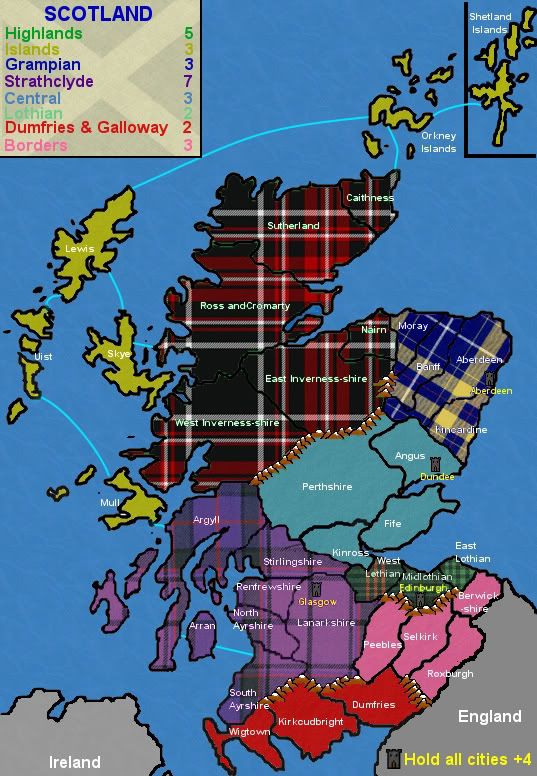
More thoughts... for starters, the basic info needs to be included in the first post: number of territories, bonuses, map size, etc. By my count there are eight bonus regions, plus a bonus for holding the cities, on a map with 37 total territories.
My first concern is that with 37 territories there won't be a game played without at least one neutral, as 37 isn't divisible by, well, anything. 36 or 42 make for cleaner starts.
Next, 37 territories and 8 bonus regions - that's a lot of small bonuses, which wouldn't be so bad if they weren't all clustered together. Every game will start the same, with players scrambling for the easy bonuses in the east. The west and north is going to become a dead area in most games, as the Islands, Highlands, and Strathclyde will each be nearly impossible to land and hold early on. Most games will be decided by placement and dice in the first four rounds.
The cities have different names than the territories they are in - this has potential to cause confusion, but i think it can be worked out if we put the city titles in a completely different style. I'm more worried about how crowded the Edinburgh territory is going to be with a city name, territory name, city graphic, and army shadow.
How were the bonus regions divided, Bals? I assume the territories are counties, but are they contemporary political counties or are these historical divisions? My understanding is that the counties have changed over time.
-
Balsiefen
- Posts: 2299
- Joined: Wed Aug 30, 2006 6:15 am
- Gender: Male
- Location: The Ford of the Aldar in the East of the Kingdom of Lindissi
- Contact:
Grampian only has 3 borders, Banff has an impassablejako wrote:just a quick question (plz note i have not read the entire thread, so this may be redundant).
y does the border's bonus only get a +3 for holding 4 terrs and defending 4 borders, while the grampian bonus also gets a +3 for holding 4 terrs but only defending 3 borders? shouldnt the border's bonus get a +4?
The bonus's in particular are out of date, i installed them close to the start and have added three territories since then: Shetland, East Inverness and North ayrshire. It is these three that are causing all of the problems.oaktown wrote:Right, I've been pondering some of the bonuses myself... strathclyde, the islands and the highlands are of similar size, yet considerably different bonuses - 7, 3, and 5.
Somebody once came up with a formula for how to assign a bonus... (# terits + # boders) / x = y, that sort of thing. Does anybody know where that is?
That would be useful if anyone can find it.
I'll do that as soon as i can, as for 37 territs, it was origionally at 34 (a bad number) so i split inverness and ayr to bring it up to 36, then, compleatlyforgetting about that, i added shetland for compleatness which is causing our problem. I think i'll recreate ayrshire to bring us down to 36 againMore thoughts... for starters, the basic info needs to be included in the first post: number of territories, bonuses, map size, etc. By my count there are eight bonus regions, plus a bonus for holding the cities, on a map with 37 total territories.
My first concern is that with 37 territories there won't be a game played without at least one neutral, as 37 isn't divisible by, well, anything. 36 or 42 make for cleaner starts.
Interesting, that is one thing i hadnt thaught of.Next, 37 territories and 8 bonus regions - that's a lot of small bonuses, which wouldn't be so bad if they weren't all clustered together. Every game will start the same, with players scrambling for the easy bonuses in the east. The west and north is going to become a dead area in most games, as the Islands, Highlands, and Strathclyde will each be nearly impossible to land and hold early on. Most games will be decided by placement and dice in the first four rounds.
Maby merging borders and lothian would help, then the two smallest conts would be Dumfries and Grampian
I had been thinking about that also, however, if the continents were merged, the mountains could be moved, giving us more space.The cities have different names than the territories they are in - this has potential to cause confusion, but i think it can be worked out if we put the city titles in a completely different style. I'm more worried about how crowded the Edinburgh territory is going to be with a city name, territory name, city graphic, and army shadow.
they were divides as sort of a mix. It seems every map on scotland contredicts the lastHow were the bonus regions divided, Bals? I assume the territories are counties, but are they contemporary political counties or are these historical divisions? My understanding is that the counties have changed over time
Here are some of my scources
http://www.dunfermlineweb.com/images/scotmap.jpg
http://users.ox.ac.uk/~peter/workhouse/map/scotland.gif
http://www.britainexpress.com/images/sc ... d-map2.gif
I will update a test map as soon as possible but im not sure when that will be
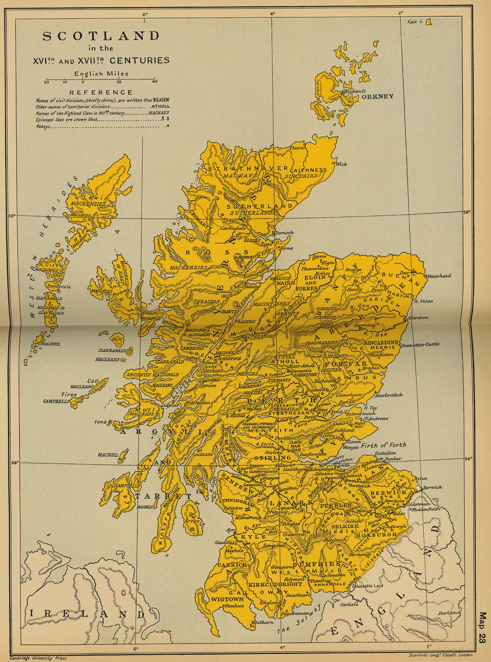
From my end it would be ideal if you could settle on one source for the territory divisions - perhaps find a map from a certain year and stick with it. Then there would be a focus for the look... a 16th century map of scotland would have a considerably different feel than a 19th or 21st century map. It would also alter which cities are key strategic points - Sterling would be a key city on a historical map, but not on a contemporary map. Personally, I think it'd be more fun to do something historical.Balsiefen wrote:they were divides as sort of a mix. It seems every map on scotland contredicts the lastoaktown wrote:How were the bonus regions divided, Bals? I assume the territories are counties, but are they contemporary political counties or are these historical divisions? My understanding is that the counties have changed over time
Here are some of my scources
http://www.dunfermlineweb.com/images/scotmap.jpg
http://users.ox.ac.uk/~peter/workhouse/map/scotland.gif
http://www.britainexpress.com/images/sc ... d-map2.gif


-
Balsiefen
- Posts: 2299
- Joined: Wed Aug 30, 2006 6:15 am
- Gender: Male
- Location: The Ford of the Aldar in the East of the Kingdom of Lindissi
- Contact:
Okay, This is the map i used for the territories. I'm afraid it is extreamly innacurate in some ways which led to early mistakes. I think it is around victorian but the names of the general reagions have been pretty consistent from the 15th centoaktown wrote:From my end it would be ideal if you could settle on one source for the territory divisions - perhaps find a map from a certain year and stick with it. Then there would be a focus for the look... a 16th century map of scotland would have a considerably different feel than a 19th or 21st century map. It would also alter which cities are key strategic points - Sterling would be a key city on a historical map, but not on a contemporary map. Personally, I think it'd be more fun to do something historical.Balsiefen wrote:they were divides as sort of a mix. It seems every map on scotland contredicts the lastoaktown wrote:How were the bonus regions divided, Bals? I assume the territories are counties, but are they contemporary political counties or are these historical divisions? My understanding is that the counties have changed over time
Here are some of my scources
http://www.dunfermlineweb.com/images/scotmap.jpg
http://users.ox.ac.uk/~peter/workhouse/map/scotland.gif
http://www.britainexpress.com/images/sc ... d-map2.gif


If anyone else is trying to check this out, note that you have to copy/paste the link to get there.Balsiefen wrote: Okay, This is the map i used for the territories. I'm afraid it is extreamly innacurate in some ways which led to early mistakes. I think it is around victorian but the names of the general reagions have been pretty consistent from the 15th cent
here are some other fun but less helful maps I've found, to give an idea of where we could push the look if you want to take it more medieval or 15th century Elizabethan...
http://www.gwp.enta.net/scotland%20large.jpg
http://www.lib.utexas.edu/maps/historic ... entury.jpg
http://www.lib.utexas.edu/maps/historic ... d_1808.jpg
http://www.oldworldauctions.com/Auction086/86-234.jpg

