
Anyway, would a small polar ice cap make that more obvious to idiots like me? Forgive me if this has already been suggested.
Duck & Cover [Quenched]
Moderator: Cartographers
Forum rules
Please read the Community Guidelines before posting.
Please read the Community Guidelines before posting.
I had to look at this map several times before realizing it was a "top down" view. (As if from space! (private joke)  ).
).
Anyway, would a small polar ice cap make that more obvious to idiots like me? Forgive me if this has already been suggested.
Anyway, would a small polar ice cap make that more obvious to idiots like me? Forgive me if this has already been suggested.

The Pro-Tip®, SkyDaddy® and
 are registered trademarks of Backglass Heavy Industries.
I mentioned that before - but I think Oaky missed it...yeti_c wrote:I wonder if you should put a bit of Ice in the middle to represent the North Pole... (That definitely still existed in the 50's!!)
Or would that make it too cluttered?!
C.
What would be ace (It's not possible) was if international borders were opened up after the first nuclear salvo was launched!!
Pre nuclear salvo movement would be restricted to same colour states!!
C.

Highest score : 2297
-
spinwizard
- Posts: 5016
- Joined: Sun Dec 10, 2006 9:52 am


No, I didn't miss it... I just forgot about it. My concern is having landmass (or in this case ice-mass) that is not playable. It wouldn't be a territory, yet it could be enough to throw players off the first time they play it. I'm going for user-friendly. But I'm not opposed to doing a quick version with an ice cap just to see what people think.yeti_c wrote:I mentioned that before - but I think Oaky missed it...yeti_c wrote:I wonder if you should put a bit of Ice in the middle to represent the North Pole... (That definitely still existed in the 50's!!)
Or would that make it too cluttered?!
The UK to Scandinavia link would make sense... it'll lock up the Europe region and ultimately make it an easier hold.
I'm about to step out for the weekend, so I'll play with it next week. In the meantime, I don't want to see anybody else using the "f" word in this thread unless it is a mod.

-
spinwizard
- Posts: 5016
- Joined: Sun Dec 10, 2006 9:52 am
-
AndyDufresne

- Posts: 24919
- Joined: Fri Mar 03, 2006 8:22 pm
- Location: A Banana Palm in Zihuatanejo
- Contact:
I think it'd be worth a shot to try the artic ice cap...that sounds like it would be perhaps the best idea. If that doesn't work, you could always add something similar to what Bad Speler did in the Artic Map (the N).oaktown wrote: No, I didn't miss it... I just forgot about it. My concern is having landmass (or in this case ice-mass) that is not playable. It wouldn't be a territory, yet it could be enough to throw players off the first time they play it. I'm going for user-friendly. But I'm not opposed to doing a quick version with an ice cap just to see what people think.
The UK to Scandinavia link would make sense... it'll lock up the Europe region and ultimately make it an easier hold.
I'm about to step out for the weekend, so I'll play with it next week. In the meantime, I don't want to see anybody else using the "f" word in this thread unless it is a mod.
I also agree with the link between UK and Scand. It'll keep flowing movement around the map.
As for F-Words, I can only think of two... Freakin' Fabulous!
--Andy

-
yamahafazer
- Posts: 211
- Joined: Fri Aug 24, 2007 9:56 am
Are you shure its not the drink thats making you a bit idiotik????Backglass wrote:I had to look at this map several times before realizing it was a "top down" view. (As if from space! (private joke)
Anyway, would a small polar ice cap make that more obvious to idiots like me? Forgive me if this has already been suggested.
hummm F words....
"Fliping Ford Fool pulled out on me again... might cos Fazands to repare my Fazer...
(didn't realy happen... I don't have a bike yet


-
reverend_kyle

- Posts: 9250
- Joined: Tue Mar 21, 2006 4:08 pm
- Location: 1000 post club
- Contact:
I think he was meaning that scandinavia looks like a ballsack.Gnome wrote:what looks wrong here unit? the pointed edge?
And the idea about the ice cap doesn't really attracts me...(I thought the ice cap was ment to be in the north or something
I think this map is really good and...
Nothing to add that bothers me...
DANCING MUSTARD FOR POOP IN '08!
-
yamahafazer
- Posts: 211
- Joined: Fri Aug 24, 2007 9:56 am
-
Unit_2

- Posts: 1834
- Joined: Sun Jan 14, 2007 12:59 pm
- Gender: Male
- Location: Pennsylvania, U.S.A, North America, Earth, Milky Way, Universe.
... yeahreverend_kyle wrote:I think he was meaning that scandinavia looks like a ballsack.Gnome wrote:what looks wrong here unit? the pointed edge?
And the idea about the ice cap doesn't really attracts me...(I thought the ice cap was ment to be in the north or something
I think this map is really good and...
Nothing to add that bothers me...


-
spinwizard
- Posts: 5016
- Joined: Sun Dec 10, 2006 9:52 am

-
rebelman

- Posts: 2968
- Joined: Thu Aug 02, 2007 5:24 pm
- Gender: Male
- Location: People's Republic of Cork
- Contact:
looking great just one small thing the top right hand corner legend its extremely difficult to make out the black writing on the deep red background
Don't now why people on here don't like being cooks, remember under siege: A former SEAL, now cook, is the only person who can stop a gang of terrorists when they sieze control of a US Navy battleship.
-
Ogrecrusher
- Posts: 250
- Joined: Thu Aug 16, 2007 2:55 pm
It looks even better on a euro coin, when Norway isn't there!oaktown wrote:right, i should change that., because in no way does scandivia look like genitalia.reverend_kyle wrote:I think he was meaning that scandinavia looks like a ballsack.
http://image.guardian.co.uk/sys-images/ ... 1euror.jpg
-
rebelman
- Posts: 2968
- Joined: Thu Aug 02, 2007 5:24 pm
- Gender: Male
- Location: People's Republic of Cork
- Contact:
norway asked not to be includedyeti_c wrote:I was always confused as to why Norway was omitted... I Assume it was because Norway doesn't have the Euro...
But then again neither does the UK!
C>
Don't now why people on here don't like being cooks, remember under siege: A former SEAL, now cook, is the only person who can stop a gang of terrorists when they sieze control of a US Navy battleship.
sorry, been strapped for time to read back over the thread. If the arctic question is still hovering i vote no, that its not necessary, on the basis that the map is more a symbolic representation of the politcal situation and forces at work, the blob in the middle would be out of this context and break up the graphical east-west that you've got going on.
If you do go for it, i'd suggest making it fadded and as inconscpicuous as possible.
Maybe you could give us an update of where the map's at, the issues in the air etc, in any case Oaktown. You working on anything else for it at the moment?
If you do go for it, i'd suggest making it fadded and as inconscpicuous as possible.
Maybe you could give us an update of where the map's at, the issues in the air etc, in any case Oaktown. You working on anything else for it at the moment?
I'm back... thanksgiving and family came before CC, believe it or not.
This update include:
• slight glow around the first line of legend text to make it easier to read against red background
• new attack route from UK to Scandinavia
• slightly adjusted outline of Scandinavia and surrounding territories
• 3 versions to choose from! Please discuss!
Version 1: north pole as before.
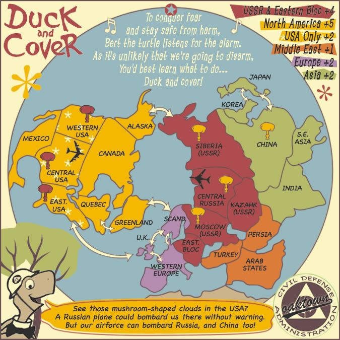
Version 2: polar ice cap with N. symbol.

Version 3: North symbol, no bird-turd ice cap.

This update include:
• slight glow around the first line of legend text to make it easier to read against red background
• new attack route from UK to Scandinavia
• slightly adjusted outline of Scandinavia and surrounding territories
• 3 versions to choose from! Please discuss!
Version 1: north pole as before.
Version 2: polar ice cap with N. symbol.
Version 3: North symbol, no bird-turd ice cap.
-
reverend_kyle
- Posts: 9250
- Joined: Tue Mar 21, 2006 4:08 pm
- Location: 1000 post club
- Contact: