British Isles map error
Moderator: Cartographers
Forum rules
Please read the Community Guidelines before posting.
Please read the Community Guidelines before posting.
-
max is gr8

- Posts: 3720
- Joined: Sat Jan 21, 2006 6:44 am
- Location: In a big ball of light sent from the future
British Isles map error
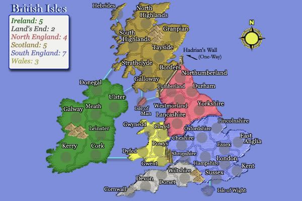
you can attack from Northumberland to borders which is very annoying in game http://www.conquerclub.com/game.php?game=12709#gmtop As you can see my ally had scotlands bonus and lost it because of this error.
‹max is gr8› so you're a tee-total healthy-eating sex-addict?
‹New_rules› Everyone has some bad habits
(4th Jan 2010)
‹New_rules› Everyone has some bad habits
(4th Jan 2010)

-
max is gr8
- Posts: 3720
- Joined: Sat Jan 21, 2006 6:44 am
- Location: In a big ball of light sent from the future

-
thegrimsleeper

- Posts: 984
- Joined: Thu Jan 26, 2006 10:40 am
- Location: Seattle
... Actually, Grim, I've had a few complaints from other folks as well.
... I've already edited the thing - just put the words, "One Way" by the arrow. Lack will no doubt put it up when he has the time.
... The large map was already so labeled, but a lot of folks don't look at the big maps - gotta scroll.
... I've already edited the thing - just put the words, "One Way" by the arrow. Lack will no doubt put it up when he has the time.
... The large map was already so labeled, but a lot of folks don't look at the big maps - gotta scroll.

Hi Nobu:
Seeing as you are updating the British Isles map (which I really enjoy, by the way), one more suggestion.
Isle of Man looks to be brown in colour (meaning it would be part of Scotland). Only after an opponent missed out on a bonus did I realize that it is actually pink in colour (and therefore part of North England).
I guess that this discrepancy in the shading is due to the colour of the circle in which the # of armies is located, and because this circle covers the entire territory (because it is so small).
I was wondering if you could either eliminate the shading that is present for that territory, or move the # of armies just off to the side of the territory to allow the true colour to show through.
Thanks.

Man, your map is really a good one. I love it. But I want do 2 little complaints:
1st: I really cant saw the Isle of Wight... If its borders would be a bit darker, maybe it would be better visible. Now, we know its there, but we cant see it.
2nd: Isle of Man seems to be connected to Hadrian's Wall, not Cumberland. Maybe changing the route to Westmorland...
Thanks for the great map!!
